L'Isle-aux-Coudres

Last updated

L'Isle-aux-Coudres
Isle de Coudre, Quebec (27216598362).jpg
L'Isle-aux-Coudres Quebec location diagram.png
Location within Charlevoix RCM
Canada Central Quebec location map.png
Red pog.svg
L'Isle-aux-Coudres
Location in central Quebec
Coordinates: 47°24′N70°23′W / 47.400°N 70.383°W / 47.400; -70.383
Country Canada
Province Quebec
Region Capitale-Nationale
RCM Charlevoix
Settled1728
ConstitutedAugust 23, 2000
Government
[1]
  MayorChristyan Dufour
   Federal riding Montmorency—Charlevoix
—Haute-Côte-Nord
   Prov. riding Charlevoix–Côte-de-Beaupré
Area
  Total100.96 km2 (38.98 sq mi)
  Land29.46 km2 (11.37 sq mi)
Population
 (2021) [2]
  Total1,116
  Density37.9/km2 (98/sq mi)
  Pop (2016-21)
Decrease2.svg 2.4%
  Dwellings
760
Time zone UTC−5 (EST)
  Summer (DST) UTC−4 (EDT)
Postal code(s)
Area code(s) 418 and 581
HighwaysNo major routes
Website www.municipaliteiac.ca OOjs UI icon edit-ltr-progressive.svg

L'Isle-aux-Coudres, is a municipality located on island aux Coudres, in the St. Lawrence River, in Charlevoix Regional County Municipality, Capitale-Nationale region, Quebec, Canada.

Contents

Variations of the official name are: La Baleine, L'Île-aux-Coudres, Saint-Bernard-de-l'Île-aux-Coudres and Saint-Louis-de-l'Isle-aux-Coudres. Locally, the following variants are also noted: Île aux Coudriers, Île Elbow, Île aux Marsouins and Île aux Socles. [3] [4]

Whereas the modern French spelling for "island" is île, the municipality uses the old French spelling of Isle. Its population centres include La Baleine in the north-east, (Saint-Louis-de-)l'Isle-aux-Coudres in the south, and Saint-Bernard-sur-Mer in the north-west facing Baie-Saint-Paul.

Access to the island are by sea (ferry) and air (airport). The free ferry service connects Saint-Bernard-sur-Mer to Saint-Joseph-de-la-Rive on the north shore of the gulf. [5] [6]

It was the setting for the classic 1963 National Film Board of Canada documentary Pour la suite du monde .

History

On September 6, 1535, during his second voyage to North America, the navigator Jacques Cartier named the island "couldres", after a hazel tree ( Corylus cornuta ), a shrub abundant in the area. [3] In 1928, the Historic Sites and Monuments Board of Canada erected a monument commemorating the anchorage of Cartier's 3 ships and the celebration of the first mass in the interior of Canada, at Saint-Bernard-sur-Mer.

Étienne de Lessart of Ste. Anne-de-Beaupré was granted title as the first Seigneur of l'Isle-aux-Coudres by Governor Buade de Frontenac on March 4, 1677. Due to a failure to develop the property to increase its value he was forced to sell the seigneurie on October 19, 1687 to the Séminaire de Québec who began to establish a monastery on the site. [7]

On October 29, 1687, Governor Denonville and Intendant Champigny granted the island as a seignory to the Seminary of Quebec, an act that was ratified on March 1, 1688. [8]

Plan of the island in 1751 Ile aux Coudres, 1751.jpg
Plan of the island in 1751

In 1728, the first concessions of land were granted to settlers, and by 1741, the Parish of Saint-Louis-de-France was formed, soon after renamed to Saint-Louis-de-l'Isle-aux-Coudres. Named after Louis IX of France, it probably was also a tribute to Louis Chaumont (or Chaumonot) de La Jaunière (ca. 1700-1776), priest of Baie-Saint-Paul from 1736 to 1767. In 1845, the Parish Municipality of Saint-Louis-de-l'Isle-aux-Coudres was formed. In 1847, it was abolished, but reestablished in 1855, and would remain the only municipality covering the entire island for the next 80 years.

The community of Saint-Bernard-sur-Mer, first known as Pointe-des-Roches until 1936, only really developed from 1902 onward. The Parish of Saint-Bernard, named in honour of Bernard of Clairvaux (ca. 1090-1153), was officially founded in 1934 when it separated from the Parish of Saint-Louis, and was incorporated as the Municipality of Saint-Bernard-de-l'Île-aux-Coudres in 1936.

In 1951, the Municipality of La Baleine was incorporated, when it separated from Saint-Louis-de-l'Isle-aux-Coudres. It was named after an incident that had occurred in the late 18th century when the islanders found a carcass of a dead whale (in French: baleine) that had stranded on the island's flats. At this point, the island was divided into three municipal entities. [3] '

On January 5, 1994, the Municipality of Saint-Bernard-de-l'Île-aux-Coudres and the Parish Municipality of Saint-Louis-de-l'Isle-aux-Coudres were merged and formed the Municipality of L'Île-aux-Coudres (new spelling). On August 23, 2000, this municipality and the Municipality of La Baleine were merged again to form the new Municipality of L'Isle-aux-Coudres (old spelling).

Geography

Peat bog and peat to dry 013 097 Isle aux Coudres.jpg
Peat bog and peat to dry

The island is about 11 kilometres (6.8 mi) long and averages 3 kilometres (1.9 mi) in width. It is thought to have been formed from material lifted up by the impact of the meteor which formed the Charlevoix region. Local streams include the Rouge River and Mare Creek.

Demographics

Catholic Church, Saint-Francois-d'Assise Parish, chemin des Coudriers Eglise Ile aux Coudres.JPG
Catholic Church, Saint-François-d'Assise Parish, chemin des Coudriers
Historical census populations – L'Isle-aux-Coudres
YearPop.±%
1921 1,114    
1931 1,208+8.4%
1941 1,409+16.6%
1951 1,676+18.9%
1956 1,699+1.4%
1961 1,691−0.5%
YearPop.±%
1966 1,670−1.2%
1971 1,522−8.9%
1976 1,496−1.7%
1981 1,492−0.3%
1986 1,443−3.3%
1991 1,383−4.2%
YearPop.±%
1996 1,345−2.7%
2001 1,319−1.9%
2006 1,296−1.7%
2011 1,279−1.3%
2016 1,143−10.6%
2021 1,116−2.4%
Population amount prior to 2000 are total of L'Île-aux-Coudres and La Baleine. Population amounts prior to 1994 are total of Saint-Louis-de-l'Isle-aux-Coudres (parish), Saint-Bernard-de-l'Île-aux-Coudres (municipality), and La Baleine.
Source: Statistics Canada

Private dwellings occupied by usual residents (2021): 583 (total dwellings: 760) [2]

Mother tongue (2021): [2]

Economy

Formerly, porpoise fishing was practiced on a broad basis, supplemented by some boat construction. Today tourism is the main industry, and the place is known for its historical sites, tourist accommodations, and craftspeople. On the beach near the ferry dock, there is a shipyard that is home to craftsmen who work according to ancestral techniques. The island is also a popular destination for cyclists. [3]

Local government

List of former mayors (since formation of current municipality): [9]

See also

Related Research Articles

<span class="mw-page-title-main">Île d'Orléans</span> Island in the Saint Lawrence River, Quebec, Canada

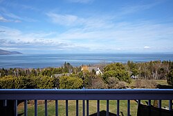
Île d'Orléans is an island located in the Saint Lawrence River about 5 kilometres (3.1 mi) east of downtown Quebec City, Quebec, Canada. It was one of the first parts of the province to be colonized by the French, and a large percentage of French Canadians can trace ancestry to early residents of the island. The island has been described as the "microcosm of traditional Quebec and as the birthplace of francophones in North America."

<span class="mw-page-title-main">L'Île-Dorval</span> City in Quebec, Canada

L'Île-Dorval is a city in southwestern Quebec, Canada. It is coterminous with Dorval Island, an island in Lake Saint-Louis off the Island of Montreal. It lies a short distance offshore from the city of Dorval and is connected with a seasonal ferry service.

<span class="mw-page-title-main">Les Îles-de-la-Madeleine, Quebec</span> Municipality in Quebec, Canada

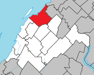
Les Îles-de-la-Madeleine is a municipality located in Gaspésie-Îles-de-la-Madeleine region, in Quebec, Canada.

<span class="mw-page-title-main">Métis-sur-Mer</span> City in Quebec, Canada

Métis-sur-Mer is a city in the La Mitis Regional County Municipality within the Bas-Saint-Laurent region of Quebec, Canada. It had a population of 587 in the Canada 2016 Census.

<span class="mw-page-title-main">L'Île-Perrot</span> City in Quebec, Canada

The Town of Île-Perrot is a town and municipality on Île Perrot in southwestern Quebec, Canada. The population as of the Canada 2016 Census was 10,756. The town is at the western end of Lake Saint-Louis, and borders the local island communities of Terrasse-Vaudreuil, Pincourt and Notre-Dame-de-l'Île-Perrot. It also includes Dowker Island and the small Claude and Bellevue Islands.

<span class="mw-page-title-main">L'Isle-Verte, Quebec</span> Municipality in Quebec, Canada

L'Isle-Verte is a small municipality located along the south shore of the Saint Lawrence River, in the Rivière-du-Loup Regional County Municipality of the Bas-Saint-Laurent region, Quebec, Canada. The name of the village refers to Île Verte, a nearby island that is not within its municipal boundaries. Village and island are joined by a seasonal ferry.

<span class="mw-page-title-main">Société des traversiers du Québec</span>

The Société des traversiers du Québec (STQ) is a ferry company which has operated some intra-provincial ferry services in Quebec since 1971. It is a crown corporation owned by the Government of Quebec.

<span class="mw-page-title-main">L'Isle-aux-Allumettes</span> Municipality in Quebec, Canada

L'Isle-aux-Allumettes is a municipality in the Outaouais region, part of the Pontiac Regional County Municipality, Quebec, Canada. The municipality consists primarily of Allumette Island, and also includes Morrison Island, Marcotte Island, and some minor islets, all in the Ottawa River north of Pembroke.

<span class="mw-page-title-main">L'Île-du-Grand-Calumet</span> Municipality in Quebec, Canada

L'Île-du-Grand-Calumet is a municipality in the Outaouais region, part of the Pontiac Regional County Municipality, Quebec, Canada. The municipality consists primarily of Calumet Island, but also includes Lafontaine Island, French Island, Green Island, and numerous minor surrounding islets, all in the Ottawa River, approximately two kilometres from Campbell's Bay, two kilometres from Bryson.

<span class="mw-page-title-main">Saint-Antonin, Quebec</span> City in Quebec, Canada

Saint-Antonin is a city in the Bas-Saint-Laurent region of Quebec, Canada, a few kilometres south of the city of Rivière-du-Loup, in Rivière-du-Loup Regional County Municipality. The municipality is named after Louis-Antonin or Antoine Proulx (1810-1896), priest of Fraserville (Rivière-du-Loup) and was founded in 1856.

<span class="mw-page-title-main">Saint-Paul-de-l'Île-aux-Noix, Quebec</span> Municipality in Quebec, Canada

Saint-Paul-de-l'Île-aux-Noix is a municipality in southern Quebec, Canada located in the administrative area of the Montérégie. The population as of the Canada 2021 Census was 2,141.

<span class="mw-page-title-main">Saint-Pierre-de-l'Île-d'Orléans</span> Municipality in Quebec, Canada

Saint-Pierre-de-l'Île-d'Orléans is a municipality in the Capitale-Nationale region of Quebec, Canada, part of the L'Île-d'Orléans Regional County Municipality. It is situated on the west side of Orléans Island, and accessible by Quebec Route 368 and the Île d'Orléans Bridge which connects Saint-Pierre with the Beauport borough of Quebec City. Until 1997, it was known simply as Saint-Pierre.

<span class="mw-page-title-main">Saint-Laurent-de-l'Île-d'Orléans</span> Municipality in Quebec, Canada

Saint-Laurent-de-l'Île-d'Orléans is a municipality in the Capitale-Nationale region of Quebec, Canada, part of the L'Île-d'Orléans Regional County Municipality. It is situated on the south side of Orléans Island. Prior to June 6, 1998 it was known simply as Saint-Laurent.

<span class="mw-page-title-main">La Visitation-de-l'Île-Dupas, Quebec</span> Municipality in Quebec, Canada

La Visitation-de-l'Île-Dupas is a municipality in the Lanaudière region of Quebec, Canada, part of the D'Autray Regional County Municipality. Its territory is located on several of the Sorel Islands in the Saint Lawrence River where it flows into Lac Saint-Pierre. The largest of these islands is Dupas Island, also known as Isle du Pads, Île d'Angoulème, and Île du Richelieu at various times in the past.

<span class="mw-page-title-main">Saint-Ignace-de-Loyola, Quebec</span> Municipality in Quebec, Canada

Saint-Ignace-de-Loyola is a municipality in the Lanaudière region of Quebec, Canada, part of the D'Autray Regional County Municipality. Its territory is located on 33 of the Sorel Islands in the Saint Lawrence River where it flows into Lac Saint-Pierre, the largest of which are île Madame, île aux Ours, and La Grande Île.

<span class="mw-page-title-main">Les Éboulements</span> Municipality in Quebec, Canada

Les Éboulements is a municipality in the Capitale-Nationale region of Quebec, Canada.

<span class="mw-page-title-main">Saint-Antoine-de-l'Isle-aux-Grues</span> Parish municipality in Quebec, Canada

Saint-Antoine-de-l'Isle-aux-Grues is a parish municipality in Quebec, in the Montmagny Regional County Municipality in the administrative region of Chaudière-Appalaches. It is known for bird-watching, goose-hunting and cheeses.

<span class="mw-page-title-main">Urban agglomeration of Les Îles-de-la-Madeleine</span>

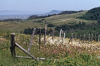
The Communauté maritime des Îles-de-la-Madeleine, commonly designated as the Agglomeration of Les Îles-de-la-Madeleine, is located on the islands of the Magdalen Islands archipelago, that bathes in the waters of the Gulf of St. Lawrence, 250 km from Gaspé, 120 km from Prince Edward Island, 90 km from Cape Breton Island and 150 km from Newfoundland. the municipality of Les Îles-de-la-Madeleine

<span class="mw-page-title-main">Carleton-sur-Mer</span> City in Quebec, Canada

Carleton-sur-Mer is the fifth largest town of the Gaspésie's south shore, in southeastern Quebec, Canada, located on Route 132, along Chaleur Bay. It is the seat of the Avignon Regional County Municipality.

References

  1. 1 2 "Répertoire des municipalités: Geographic code 16023". www.mamh.gouv.qc.ca (in French). Ministère des Affaires municipales et de l'Habitation. Retrieved 2024-03-08.
  2. 1 2 3 4 "L'Isle-aux-Coudres (Code 2416023) Census Profile". 2021 census . Government of Canada - Statistics Canada . Retrieved 2024-03-08.
  3. 1 2 3 4 "Island aux Coudres". Commission de toponymie Quebec (in French). Government of Quebec. 1968-12-05. Retrieved 2023-12-31. It is because of the presence of couldres, the ancient name given to hazelnuts, that Cartier chose this name to designate the island
  4. "L'Isle-aux-Coudres (Municipalité)". Commission de toponymie Quebec (in French). Government of Quebec. 2000-11-09. Retrieved 2023-12-31. Variations of official name: La Baleine, L'Île-aux-Coudres, Saint-Bernard-de-l'Île-aux-Coudres and Saint-Louis-de-l'Isle-aux-Coudres. Locally, there are also the following variants: Île aux Coudriers, Île Elbow, Île aux Marsouins and Île aux Socles.
  5. "Île aux Coudres Airport" (in French). 2023-12-31. Retrieved 2023-12-31. Small airport whit one pist 17/35. pseudo-code OACI de CTA3
  6. "Ferry L'Isle-aux-Coudres – Saint-Joseph-de-la-Rive". La Société des traversiers du Québec. 2023-12-31. Retrieved 2023-12-31. Schedule
  7. Lucien Gagné (1969). "Étienne de Lessard" (in French). Dictionnaire biographique du Canada. Retrieved 2024-01-08. pioneer of the Côte de Beaupré, seigneur of Île-aux-Coudres and co-seigneur of Lanoraie
  8. "Seigneurie de l'Île-aux-Coudres" (in French). Commission de toponymie du Québec. Retrieved 2010-05-07.
  9. "Répertoire des entités géopolitiques: L'Isle-aux-Coudres (municipalité) 23.8.2000 - ..." www.mairesduquebec.com. Institut généalogique Drouin. Retrieved 8 March 2024.