The Explorer program is a NASA exploration program that provides flight opportunities for physics, geophysics, heliophysics, and astrophysics investigations from space. Launched in 1958, Explorer 1 was the first spacecraft of the United States to achieve orbit. Over 90 space missions have been launched since. Starting with Explorer 6, it has been operated by NASA, with regular collaboration with a variety of other institutions, including many international partners.

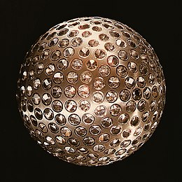
A retroreflector is a device or surface that reflects radiation back to its source with minimum scattering. This works at a wide range of angle of incidence, unlike a planar mirror, which does this only if the mirror is exactly perpendicular to the wave front, having a zero angle of incidence. Being directed, the retroflector's reflection is brighter than that of a diffuse reflector. Corner reflectors, and cat's eye reflectors are the most used kinds.

The Goddard Space Flight Center (GSFC) is a major NASA space research laboratory located approximately 6.5 miles (10.5 km) northeast of Washington, D.C. in Greenbelt, Maryland, United States. Established on May 1, 1959 as NASA's first space flight center, GSFC employs approximately 10,000 civil servants and contractors. It is one of ten major NASA field centers, named in recognition of American rocket propulsion pioneer Robert H. Goddard. GSFC is partially within the former Goddard census-designated place; it has a Greenbelt mailing address.

In satellite laser ranging (SLR) a global network of observation stations measures the round trip time of flight of ultrashort pulses of light to satellites equipped with retroreflectors. This provides instantaneous range measurements of millimeter level precision which can be accumulated to provide accurate measurement of orbits and a host of important scientific data. The laser pulse can also be reflected by the surface of a satellite without a retroreflector, which is used for tracking space debris.

TOPEX/Poseidon was a joint satellite altimeter mission between NASA, the U.S. space agency; and CNES, the French space agency, to map ocean surface topography. Launched on August 10, 1992, it was the first major oceanographic research satellite. TOPEX/Poseidon helped revolutionize oceanography by providing data previously impossible to obtain. Oceanographer Walter Munk described TOPEX/Poseidon as "the most successful ocean experiment of all time." A malfunction ended normal satellite operations in January 2006.

The Meteor spacecraft are weather observation satellites launched by the Soviet Union and Russia. The Meteor satellite series was initially developed during the 1960s. The Meteor satellites were designed to monitor atmospheric and sea-surface temperatures, humidity, radiation, sea ice conditions, snow-cover, and clouds.

The STARSHINE series of three artificial satellites were student participatory missions sponsored by the United States Naval Research Laboratory.
Kosmos 7, also known as Zenit-2 No.4 and occasionally in the West as Sputnik 17 was a Soviet reconnaissance satellite launched in 1962. It was the seventh satellite to be designated under the Kosmos system, and the second successful launch of a Soviet reconnaissance satellite.
Kosmos 26, also known as DS-MG No.1 was a scientific satellite which was launched by the Soviet Union in 1964. This mission studied the Earth's magnetic field and, along with Kosmos 49, represented the USSR contribution to the International Quiet Solar Year World Magnetic Survey. The corresponding American measurements were performed by the satellites OGO 2 and OGO 4.

LARES is a passive satellite of the Italian Space Agency.
CryoSat-1, also known as just CryoSat, was a European Space Agency satellite which was lost in a launch failure in 2005. It was to have been operated as part of the CryoSat programme to study the Earth's polar ice caps.

STSat-2C, or Science and Technology Satellite-2C, or Naro Science Satellite (ko:나로과학위성) was a South Korean satellite which was launched in 2013. It was operated by the Korea Aerospace Research Institute (KARI), and was intended to demonstrate technology for future spacecraft. The satellite had a mass of 100 kg (220 lb), and was expected to operate for less than a year.

GEOS-3, or Geodynamics Experimental Ocean Satellite 3, or GEOS-C, was the third and final satellite as part of NASA's Geodetic Earth Orbiting Satellite/Geodynamics Experimental Ocean Satellite program (NGSP) to better understand and test satellite tracking systems. For GEOS 1 and GEOS 2, the acronym stands for Geodetic Earth Orbiting Satellite; this was changed for GEOS-3.

BLITS is a Russian satellite launched on September 17, 2009, as a secondary payload on a Soyuz-2.1b/Fregat, from the Baikonur Cosmodrome in Kazakhstan. The satellite is totally passive and spherical, and is tracked using satellite laser ranging (SLR) by the International Laser Ranging Service. The design of BLITS is based on the optical Luneburg lens concept. The retroreflector is a multilayer glass sphere; it provides uniform reflection characteristics when viewed within a very wide range of angles, and can provide a cross-section sufficient for observations at low to medium orbit heights. A similar design was already tested on a smaller laser reflector carried on board of the METEOR-3M spacecraft launched on December 10, 2001.

Meteor-3M No.1 was the first and only of the Meteor-3M series polar-orbiting weather satellites. It was launched on 10 December 2001 at 17:18:57 UTC from the Baikonur Cosmodrome in Kazakhstan. The satellite is in a sun-synchronous orbit with an ascending node time of about 9AM.
Starlette and Stella are nearly identical French geodetic and geophysical satellites. Starlette was launched on 6 February 1975 and Stella on 26 September 1993. Starlette was the first passive laser satellite developed.