LaVale, Maryland | |
---|---|
Coordinates: 39°39′17″N78°48′46″W / 39.65472°N 78.81278°W | |
Country | United States |
State | Maryland |
County | Allegany |
Area | |
• Total | 9.12 sq mi (23.61 km2) |
• Land | 9.11 sq mi (23.60 km2) |
• Water | 0.00 sq mi (0.01 km2) |
Elevation | 784 ft (239 m) |
Population (2020) | |
• Total | 4,201 |
• Density | 460.99/sq mi (177.99/km2) |
Time zone | UTC−5 (Eastern (EST)) |
• Summer (DST) | UTC−4 (EDT) |
ZIP codes | 21502, 21504 |
Area code(s) | 301, 240 |
FIPS code | 24-46075 |
GNIS feature ID | 0590618 |
LaVale is a census-designated place (CDP) in Allegany County, Maryland, United States. It is part of the Cumberland, MD-WV Metropolitan Statistical Area. The population was 4,201 as of the 2020 census. [2]
LaVale is located at 39°39′17″N78°48′46″W / 39.654737°N 78.812691°W , [3] in the shadow of Haystack Mountain. To the east is Cumberland, accessible via the Cumberland Narrows, a water gap between Haystack Mountain to the south and Wills Mountain to the north. To the west is Piney Mountain and Frostburg. LaVale is located along the National Road, one of the original highways built in the United States which carried early American settlers west of the Appalachian Mountains. LaVale is a business center that contains the largest concentration of retail and the only indoor shopping mall, Country Club Mall, in the Cumberland Metropolitan area.
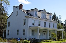
The LaVale Tollgate House was listed on the National Register of Historic Places in 1971. [4]
According to the United States Census Bureau, the CDP has a total area of 2.7 square miles (6.9 km2), all land. [5]
Census | Pop. | Note | %± |
---|---|---|---|
2020 | 4,201 | — | |
U.S. Decennial Census [6] |
As of the census [7] of 2000, there were 4,613 people, 1,924 households, and 1,377 families residing in the CDP. The population density was 567.9 inhabitants per square mile (219.3/km2). There were 2,045 housing units at an average density of 251.8 per square mile (97.2/km2). The racial makeup of the CDP was 97.59% White, 0.65% African American, 0.04% Native American, 1.02% Asian, 0.02% Pacific Islander, 0.13% from other races, and 0.54% from two or more races. Hispanic or Latino of any race were 0.48% of the population.
There were 1,924 households, out of which 26.7% had children under the age of 18 living with them, 61.7% were married couples living together, 7.6% had a female householder with no husband present, and 28.4% were non-families. 25.1% of all households were made up of individuals, and 14.2% had someone living alone who was 65 years of age or older. The average household size was 2.38 and the average family size was 2.82.
In the CDP, the population was spread out, with 20.6% under the age of 18, 7.0% from 18 to 24, 24.3% from 25 to 44, 27.6% from 45 to 64, and 20.6% who were 65 years of age or older. The median age was 44 years. For every 100 females, there were 94.6 males. For every 100 females age 18 and over, there were 89.0 males.
The median income for a household in the CDP was $42,911, and the median income for a family was $48,494. Males had a median income of $33,125 versus $23,179 for females. The per capita income for the CDP was $20,989. About 4.8% of families and 7.3% of the population were below the poverty line, including 4.9% of those under age 18 and 5.1% of those age 65 or over.
The LaVale Public Library is part of the Allegany Country Library System. The first public library in LaVale opened on April 18, 1953. The current building opened on September 28, 1975. [8] The library temporarily closed for major renovations in 2020, and reopened on September 22, 2022. At over 18,000 square feet, nearly double the original size, the newly-renovated and expanded library houses the largest collection of materials in the Allegany County Library System, and is home to large conference spaces, group study areas, an open-air patio that doubles as an outdoor classroom, and a "library of things," where patrons can borrow from a selection of everyday household items. [9] [10]
LaVale is served by the Allegany County Public Schools district. Students in LaVale are zoned for the following schools:
Allegany County is located in the northwestern part of the U.S. state of Maryland. As of the 2020 census, the population was 68,106. Its county seat is Cumberland. The name Allegany may come from a local Lenape word, welhik hane or oolikhanna, which means 'best flowing river of the hills' or 'beautiful stream'. A number of counties and a river in the Appalachian region of the U.S. are named Allegany, Allegheny, or Alleghany. Allegany County is part of the Cumberland metropolitan area. It is a part of the Western Maryland "panhandle".
Washington County is located in the western part of the U.S. state of Maryland. As of the 2020 census, the population was 154,705. It is the most populous county in the Western Maryland region and its county seat is Hagerstown.
Long Hill is a census-designated place (CDP) in the town of Groton in New London County, Connecticut, United States. The population was 4,205 at the 2010 census.
Mountain Park is an unincorporated community and census-designated place (CDP) in Gwinnett County, Georgia, United States. The population was 11,554 at the 2010 census. The older name for the area is Trickum, which is reflected in Five Forks-Trickum Road which bisects the community. The older community was centered on Five Forks and Rockbridge Roads.
Cumberland Center is a census-designated place (CDP) within the town of Cumberland in Cumberland County, Maine, United States. The population was 2,499 at the 2010 census. It is part of the Portland – South Portland – Biddeford, Maine, Metropolitan Statistical Area.
Barton is a town in Allegany County, Maryland, United States, located along the Georges Creek Valley. It is part of the Cumberland, MD-WV Metropolitan Statistical Area. The population was 457 at the 2010 census.
Cresaptown-Bel Air was a census-designated place in Allegany County, Maryland, United States. The population was 5,884 at the 2000 census. For the 2010 census, the area was separated into two CDPs, Cresaptown and Bel Air.
Cumberland is a city in and the county seat of Allegany County, Maryland, United States. At the 2020 census, the city had a population of 19,075. Located on the Potomac River, Cumberland is a regional business and commercial center for Western Maryland and the Potomac Highlands of West Virginia. It is the primary city of the Cumberland metropolitan area, which had 95,044 residents in 2020.
Lonaconing is a town in Allegany County, Maryland, United States, located along the Georges Creek Valley. It is part of the Cumberland, MD-WV Metropolitan Statistical Area. The population was 1,214 at the 2010 census.
Midland is a town in Allegany County, Maryland, United States, along the Georges Creek Valley. It is part of the Cumberland, MD-WV Metropolitan Statistical Area. The population was 446 at the 2010 census. Midland was founded in 1850 as a coal-mining community, though today only some strip mining remains.
Lake Shore is a census-designated place and unincorporated community in Anne Arundel County, Maryland, United States, located east of Pasadena. The population of Lake Shore was 19,477 at the 2010 census.
Pasadena is a census-designated place (CDP) in Anne Arundel County, Maryland, United States. The population was 24,287 at the 2010 census.
Milford Mill is an unincorporated community and census-designated place in Baltimore County, Maryland, United States. Per the 2020 census, the population was 30,622.
West Laurel is an unincorporated area and census-designated place (CDP) in Prince George's County, Maryland, United States. Per the 2020 census, the population was 4,428.
St. Bonaventure is a hamlet and census-designated place (CDP) in the town of Allegany in Cattaraugus County, New York, United States. The population was 1,963 at the 2020 census.
Mountain Top is an unincorporated area and census-designated place (CDP) in Luzerne County, Pennsylvania, United States. As of the 2010 census, its population was 10,982.
Sewanee is a census-designated place (CDP) in Franklin County, Tennessee, United States. The population was 2,535 at the 2020 census. It is part of the Tullahoma, Tennessee Micropolitan Statistical Area.
Monte Alto is a census-designated place (CDP) in Hidalgo County, Texas, United States. The population was 1,924 at the 2010 census, up from 1,611 in 2000. It is part of the McAllen–Edinburg–Mission Metropolitan Statistical Area.
Ramtown is a census-designated place and unincorporated community located within Howell Township, in Monmouth County, in the U.S. state of New Jersey. As of the 2010 United States Census, the CDP's population was 6,242.
Mount Savage is an unincorporated community and census-designated place (CDP) in Allegany County, Maryland, United States. As of the 2010 census it had a population of 873.