La Corne, Quebec

Last updated
La Corne
La Corne QC.JPG
La Corne Quebec location diagram.png
Location within Abitibi RCM.
Canada Western Quebec location map.png
Red pog.svg
La Corne
Location in western Quebec.
Coordinates: 48°21′N78°00′W / 48.350°N 78.000°W / 48.350; -78.000 Coordinates: 48°21′N78°00′W / 48.350°N 78.000°W / 48.350; -78.000 [1]
CountryFlag of Canada.svg  Canada
Province Flag of Quebec.svg  Quebec
Region Abitibi-Témiscamingue
RCM Abitibi
Settledc. 1935
ConstitutedAugust 2, 1975
Government
[2]
  MayorMichel Lévesque
   Federal riding Abitibi—Témiscamingue
   Prov. riding Abitibi-Ouest
Area
  Total329.90 km2 (127.38 sq mi)
  Land310.43 km2 (119.86 sq mi)
Population
(2011) [3]
  Total700
  Density2.3/km2 (6/sq mi)
  Pop 2006-2011
Increase2.svg 2.6%
  Dwellings
404
Time zone UTC−5 (EST)
  Summer (DST) UTC−4 (EDT)
Postal code(s)
Area code(s) 819
HighwaysQc111.svg Route 111
Website www.lacorne.ca

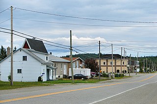
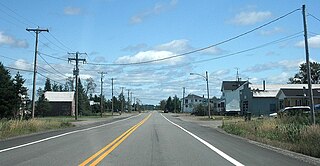
La Corne is a municipality in the Canadian province of Quebec in Abitibi Regional County Municipality.

Provinces and territories of Canada Top-level subdivisions of Canada

The provinces and territories of Canada are sub-national governments within the geographical areas of Canada under the authority of the Canadian Constitution. In the 1867 Canadian Confederation, three provinces of British North America—New Brunswick, Nova Scotia, and the Province of Canada —were united to form a federated colony, becoming a sovereign nation in the next century. Over its history, Canada's international borders have changed several times, and the country has grown from the original four provinces to the current ten provinces and three territories. Together, the provinces and territories make up the world's second-largest country by area.

Quebec Province of Canada

Quebec is one of the thirteen provinces and territories of Canada. It is bordered to the west by the province of Ontario and the bodies of water James Bay and Hudson Bay; to the north by Hudson Strait and Ungava Bay; to the east by the Gulf of Saint Lawrence and the province of Newfoundland and Labrador; and to the south by the province of New Brunswick and the U.S. states of Maine, New Hampshire, Vermont, and New York. It also shares maritime borders with Nunavut, Prince Edward Island, and Nova Scotia. Quebec is Canada's largest province by area and its second-largest administrative division; only the territory of Nunavut is larger. It is historically and politically considered to be part of Central Canada.

Abitibi Regional County Municipality Regional county municipality in Quebec, Canada

Abitibi Regional County Municipality is a regional county municipality in the Abitibi-Témiscamingue region of Quebec. The seat is Amos.

Contents

The place is named in honour of Louis de La Corne (1703–1761), a French naval officer who was wounded in the Battle of Sainte-Foy in 1760. Until 1978, the place name was incorrectly spelled as Lacorne. [1]

Battle of Sainte-Foy 1760 battle between French & British near Ste-Foy, Québec, Canada

The Battle of Sainte-Foy, sometimes called the Battle of Quebec, was fought on April 28, 1760 near the British-held town of Quebec in the French province of Canada during the Seven Years' War. It was a victory for the French under the Chevalier de Lévis over the British army under General Murray. The battle was notably bloodier than the Battle of the Plains of Abraham of the previous September, with 833 French casualties to 1,124 British casualties. It was the last French victory in North America.

From 1955 to 1965, La Corne was home to Canada's only lithium mine. The underground mine had a 150 metres (490 ft) deep shaft and lateral workings on three levels, and provided lithium to the glass and ceramics industries. With the advent of lithium batteries for electric cars and a myriad of consumer electronic products, the mine is currently being studied for reopening in late 2012 as an open-pit mine. [4]

Lithium Chemical element with atomic number 3

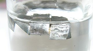
Lithium is a chemical element with symbol Li and atomic number 3. It is a soft, silvery-white alkali metal. Under standard conditions, it is the lightest metal and the lightest solid element. Like all alkali metals, lithium is highly reactive and flammable, and is stored in mineral oil. When cut, it exhibits a metallic luster, but moist air corrodes it quickly to a dull silvery gray, then black tarnish. It never occurs freely in nature, but only in compounds, such as pegmatitic minerals, which were once the main source of lithium. Due to its solubility as an ion, it is present in ocean water and is commonly obtained from brines. Lithium metal is isolated electrolytically from a mixture of lithium chloride and potassium chloride.

Lithium battery

Lithium batteries are primary batteries that have metallic lithium as an anode. These types of batteries are also referred to as lithium-metal batteries.

Demographics

Population trend: [5]

Private dwellings occupied by usual residents: 283 (total dwellings: 404)

Mother tongue: [6]

Municipal council

Related Research Articles

Alma, Quebec Town in Quebec, Canada

Alma is a town in the Canadian province of Quebec.

Amos, Quebec Town in Quebec, Canada

Amos is a town in northwestern Quebec, Canada, on the Harricana River. It is the seat of Abitibi Regional County Municipality.

Malartic, Quebec City in Quebec, Canada

Malartic is a town on the Malartic River in northwestern Quebec, Canada, in the La Vallée-de-l'Or Regional County Municipality. It is located about 80 kilometres (50 mi) east of the centre of Rouyn-Noranda along Quebec Route 117 and the Canadian National Railway.

Barraute, Quebec Municipality in Quebec, Canada

Barraute is a municipality in the Canadian province of Quebec, located in the Abitibi Regional County Municipality.

Preissac, Quebec Municipality in Quebec, Canada

Preissac is a municipality in the Canadian province of Quebec, located in the Abitibi Regional County Municipality. The village of Preissac itself is located at the north end of Lake Preissac.

Saint-Dominique-du-Rosaire, Quebec Municipality in Quebec, Canada

Saint-Dominique-du-Rosaire is a municipality in the Canadian province of Quebec, located in the Abitibi Regional County Municipality. It is part of the census agglomeration of Amos.

Sainte-Gertrude-Manneville, Quebec Municipality in Quebec, Canada

Sainte-Gertrude-Manneville is a municipality in the Canadian province of Quebec, located in Abitibi Regional County Municipality. It includes the population centres of Sainte-Gertrude-de-Villeneuve and Manneville.

Saint-Félix-de-Dalquier, Quebec Municipality in Quebec, Canada

Saint-Félix-de-Dalquier is a municipality in the Canadian province of Quebec, located in the Abitibi Regional County Municipality.

Launay, Quebec Township municipality in Quebec, Canada

Launay is a township municipality in the Canadian province of Quebec, located in the Abitibi Regional County Municipality.

Trécesson, Quebec Township municipality in Quebec, Canada

Trécesson is a township municipality in the Canadian province of Quebec, located in the Abitibi Regional County Municipality. It encompasses the communities of Clercs-Saint-Viateur, La Ferme, Lac-Davy, Trécesson, and Villemontel.

Duparquet City in Quebec, Canada

Duparquet is a ville in northwestern Quebec, Canada in the MRC d'Abitibi-Ouest. It covers 157.4 km2 (60.8 sq mi) and had a population of 657 as of the Canada 2011 Census.

Palmarolle Municipality in Quebec, Canada

Palmarolle is a municipality in northwestern Quebec, Canada, in the Abitibi-Ouest Regional County Municipality. It covers 118.36 km² and had a population of 1,465 as of the Canada 2011 Census. It is considered to have the best agricultural land of the entire Abitibi region.

Poularies, Quebec Municipality in Quebec, Canada

Poularies is a municipality in northwestern Quebec, Canada in the Abitibi-Ouest Regional County Municipality. It covers 164.95 km² and had a population of 679 as of the Canada 2011 Census.

Rapide-Danseur, Quebec Municipality in Quebec, Canada

Rapide-Danseur is a municipality in northwestern Quebec, Canada, in the Abitibi-Ouest Regional County Municipality. It covers 185.18 km² and had a population of 312 as of the Canada 2011 Census.

Guérin, Quebec Township municipality in Quebec, Canada

Guérin is a township municipality in northwestern Quebec, Canada, in the Témiscamingue Regional County Municipality. It was named for James John Edmund Guerin.

Senneterre, Quebec (parish) Parish municipality in Quebec, Canada

Senneterre is a parish municipality in northwestern Quebec, Canada, in the La Vallée-de-l'Or Regional County Municipality. The parish is mostly a rural municipality that almost completely surrounds the actual population centre of the neighbouring City of Senneterre.

Saint-André-dArgenteuil, Quebec Municipality in Quebec, Canada

Saint-André-d'Argenteuil is a municipality in the Laurentides region of Quebec, Canada, part of the Argenteuil Regional County Municipality. It is located along the Ottawa River, just south of Lachute.

Saint-André-du-Lac-Saint-Jean, Quebec Village municipality in Quebec, Canada

Saint-André-du-Lac-Saint-Jean is a village municipality in Quebec, Canada.

Saint-André-de-Restigouche Municipality in Quebec, Canada

Saint-André-de-Restigouche is a municipality in Quebec, Canada.

Labrecque, Quebec Municipality in Quebec, Canada

Labrecque is a municipality in Quebec, Canada.

References

  1. 1 2 Reference number 72436 of the Commission de toponymie du Québec (in French)
  2. 1 2 "La Corne". Répertoire des municipalités (in French). Ministère des Affaires municipales, des Régions et de l'Occupation du territoire. Retrieved 2011-01-11.
  3. 1 2 "La Corne census profile". 2011 Census data . Statistics Canada. Retrieved 2011-01-11.
  4. "Quebec Lithium Project". Canada Lithium Corp. Retrieved 2011-01-11.
  5. Statistics Canada: 1996, 2001, 2006, 2011 census
  6. "La Corne community profile". 2006 Census data . Statistics Canada. Retrieved 2011-01-11.