Lac-Despinassy, Quebec

Last updated
Lac-Despinassy
Unorganized territory

Despinassy QC.JPG

Despinassy
Lac-Despinassy Quebec location diagram.png
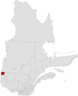
Location within Abitibi RCM.
Canada Western Quebec location map.png
Red pog.svg
Lac-Despinassy
Location in western Quebec.
Coordinates: 48°47′N77°20′W / 48.783°N 77.333°W / 48.783; -77.333 Coordinates: 48°47′N77°20′W / 48.783°N 77.333°W / 48.783; -77.333 [1]
CountryFlag of Canada.svg  Canada
Province Flag of Quebec.svg  Quebec
Region Abitibi-Témiscamingue
RCM Abitibi
Constituted January 1, 1986
Government [2] [3]
   Federal riding Abitibi—Témiscamingue
   Prov. riding Abitibi-Ouest
Area [2] [4]
  Total 1,856.10 km2 (716.64 sq mi)
  Land 1,859.44 km2 (717.93 sq mi)
 There is an apparent
contradiction between two
authoritative sources
Population (2011) [4]
  Total 15
  Density 0.0/km2 (0/sq mi)
  Pop 2006-2011Decrease2.svg 40.0%
  Dwellings 15
Time zone EST (UTC−5)
  Summer (DST) EDT (UTC−4)
Area code(s) 819
HighwaysQc397.svg Route 397

Lac-Despinassy is an unorganized territory in the Canadian province of Quebec, located within the Abitibi Regional County Municipality. The area is east of the municipality of Saint-Dominique-du-Rosaire, north of La Morandière, Rochebaucourt and the parish municipality of Senneterre, and west of the city of Senneterre. [5]

Provinces and territories of Canada Top-level subdivisions of Canada

The provinces and territories of Canada are sub-national governments within the geographical areas of Canada under the authority of the Canadian Constitution. In the 1867 Canadian Confederation, three provinces of British North America—New Brunswick, Nova Scotia, and the Province of Canada —were united to form a federated colony, becoming a sovereign nation in the next century. Over its history, Canada's international borders have changed several times, and the country has grown from the original four provinces to the current ten provinces and three territories. Together, the provinces and territories make up the world's second-largest country by area.

Quebec Province of Canada

Quebec is one of the thirteen provinces and territories of Canada. It is bordered to the west by the province of Ontario and the bodies of water James Bay and Hudson Bay; to the north by Hudson Strait and Ungava Bay; to the east by the Gulf of Saint Lawrence and the province of Newfoundland and Labrador; and to the south by the province of New Brunswick and the U.S. states of Maine, New Hampshire, Vermont, and New York. It also shares maritime borders with Nunavut, Prince Edward Island, and Nova Scotia. Quebec is Canada's largest province by area and its second-largest administrative division; only the territory of Nunavut is larger. It is historically and politically considered to be part of Central Canada.

Abitibi Regional County Municipality Regional county municipality in Quebec, Canada

Abitibi Regional County Municipality is a regional county municipality in the Abitibi-Témiscamingue region of Quebec. The seat is Amos.

The eponymous Lake Despinassy is the territory's largest lake and is named after the geographic township of Despinassy. This name was already assigned to the area in 1911 and comes from Louis-Auguste-Victor Despinassy, a lieutenant of the Royal Artillery and Engineers Corps in General Montcalm's army. The township is swampy, mostly forested, and flat, not exceeding 325 metres (1,066 ft) above sea level. The Hurault and Lavigne Creeks, as well as the Despinassy and Laflamme Rivers, flow through the territory, while the Bell River forms its eastern boundary. [1] [6]

Louis-Joseph de Montcalm French general

Louis-Joseph de Montcalm-Grozon, marquis de Montcalm de Saint-Veran was a French soldier best known as the commander of the forces in North America during the Seven Years' War.

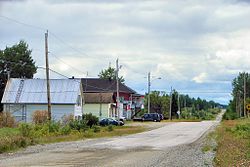
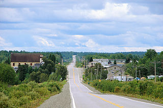
A few kilometres west from Lake Despinassy along Route 397 is the hamlet of Despinassy ( 48°45′48″N77°26′26″W / 48.76333°N 77.44056°W / 48.76333; -77.44056 ), the territory's only population centre. Founded in 1948, it is one of the youngest communities in the Abitibi. By 1952, there were 140 families, but most have since left. [1] Currently the area is being explored for potential mining of gold deposits. [7]

Quebec Route 397 highway in Quebec

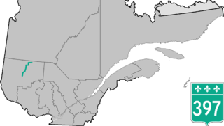
Route 397 is a two-lane north/south highway located in the Abitibi-Témiscamingue region in Quebec, Canada. It starts at the junction of Route 117 in Val-d'Or and ends at the junction of Route 113 in Lac-Despinassy. It is also concurrent with Route 386 in Barraute.

Demographics

Population trend: [8]

Related Research Articles

Abitibi-Ouest Regional County Municipality Regional county municipality in Quebec, Canada

Abitibi-Ouest Regional County Municipality is a regional county municipality located in the Abitibi-Témiscamingue region of Quebec. Its seat is La Sarre.

Senneterre, Quebec City in Quebec, Canada

Senneterre is a town in the Abitibi-Témiscamingue region of northwestern Quebec, Canada. It is in the Vallée-de-l'Or Regional County Municipality. The town's territory includes a vast undeveloped area stretching from the Bell River to the Mauricie region. The town centre itself is about 60 kilometres (37 mi) northeast of Val-d'Or on the banks of the Bell River, at the intersection of the Canadian National Railway and Quebec Route 113.

Lebel-sur-Quévillon City in Quebec, Canada

Lebel-sur-Quévillon is a city in the Canadian province of Quebec, located on Route 113 in the Jamésie region. It is located approximately 88 kilometres north of Senneterre and approximately 200 kilometres southwest of Chibougamau. It is surrounded by, but not a part of, the municipality of Baie-James.

Abitibi-Est is a provincial electoral district in the Abitibi-Témiscamingue region of Quebec, Canada, that elects members to the National Assembly of Quebec. The district includes eastern portions of the city of Rouyn-Noranda, all of the city of Val-d'Or and the municipalities of Senneterre and Malartic.

La Morandière, Quebec Municipality in Quebec, Canada

La Morandière is a municipality in the Canadian province of Quebec, located in the Abitibi Regional County Municipality.

La Motte, Quebec Municipality in Quebec, Canada

La Motte is a municipality in the Canadian province of Quebec, located in the Abitibi Regional County Municipality and the administrative region of Abitibi-Témiscamingue.

Macamic, Quebec City in Quebec, Canada

Macamic is a ville in northwestern Quebec, Canada, in the Abitibi-Ouest Regional County Municipality. It covers 202.34 km² and had a population of 2,734 in the Canada 2011 Census.

Nédélec, Quebec Township municipality in Quebec, Canada

Nédélec is a township municipality in western Quebec, Canada, in the Témiscamingue Regional County Municipality.

Lac-Chicobi, Quebec Unorganized territory in Quebec, Canada

Lac-Chicobi is an unorganized territory in the Canadian province of Quebec, located within the Abitibi Regional County Municipality. The area consists of two non-contiguous portions on either side of the incorporated municipality of Berry.

Les Lacs-du-Témiscamingue, Quebec Unorganized territory in Quebec, Canada

Les Lacs-du-Témiscamingue is a vast unorganized territory in the Abitibi-Témiscamingue region of Quebec, Canada. With a surface area of 10,410 square kilometres (4,020 sq mi), it takes up over 60% of the eastern portion of the Témiscamingue Regional County Municipality.

Duhamel, Quebec Municipality in Quebec, Canada

Duhamel is a town and municipality in the Outaouais region of Quebec, Canada. It is the largest municipality in surface area in the Papineau Regional County Municipality.

Matchi-Manitou, Quebec Unorganized territory in Quebec, Canada

Matchi-Manitou is an unorganized territory in the Abitibi-Témiscamingue region of Quebec, Canada. It is one of five unorganized territories in La Vallée-de-l'Or Regional County Municipality.

Lac-Granet, Quebec Unorganized territory in Quebec, Canada

Lac-Granet is an unorganized territory in the Abitibi-Témiscamingue region of Quebec, Canada. It is one of five unorganized territories in the La Vallée-de-l'Or Regional County Municipality.

Lac-Metei, Quebec Unorganized territory in Quebec, Canada

Lac-Metei is an unorganized territory in the Abitibi-Témiscamingue region of Quebec, Canada. It is one of five unorganized territories in the La Vallée-de-l'Or Regional County Municipality.

Lac-des-Plages, Quebec Municipality in Quebec, Canada

Lac-des-Plages is a town and municipality in the Outaouais region of Quebec, Canada, part of the Papineau Regional County Municipality. It is named after Lac des Plages which attracts many vacationers with the beauty of its beaches.

Lac-Masketsi Unorganized territory in Quebec, Canada

Lac-Masketsi is an unorganized territory in the Mauricie region of province of Quebec, Canada, part of the Mékinac Regional County Municipality. Most of its area is part of the Zec Tawachiche. The discharge of Masketsi Lake at the south-east flows in the Little Lake Masketsi, which empties into the Tawachiche West River.

Lac-Lapeyrère, Quebec Unorganized territory in Quebec, Canada

Lake Lapeyrère is a municipal unorganized territory, part of Portneuf in Quebec, (Canada). The RCM is included in the administrative region of the Capitale-Nationale. This area of the north shore of St. Lawrence river and the west bank of the Batiscan River is located about 75 kilometers northeast of Shawinigan, Quebec. The unorganized territory Lac-Lapeyrère includes Lapeyrère Township, which was established in 1907. The canton is one sector of Portneuf Wildlife Reserve and Zec Tawachiche. Territory Lac-Lapeyrère has several major water bodies including lakes Garneau, Travers, Robinson, Casgrain, Tage and Lapeyrère, and is drained to the east by the Batiscan River.

Berthelot Lake Lake crossed by the Mégiscane River (Nottaway Slope), in Senneterre, Abitibi-Témiscamingue, Quebec, Canada

Berthelot Lake is a freshwater body of Berthelot Township, in the Senneterre territory, in La Vallée-de-l'Or Regional County Municipality (RCM), in the administrative region of Abitibi-Témiscamingue, in the province of Quebec, in Canada.

Faillon Lake water body of Senneterre, in the MRC La Vallée-de-lOr, in Abitibi-Témiscamingue, Quebec, Canada.

Faillon Lake is a freshwater body of the townships of Faillon and Boisseau, in the territory of Senneterre, in La Vallée-de-l'Or Regional County Municipality (RCM), in the administrative region of Abitibi-Témiscamingue, in the province of Quebec, in Canada.

References

  1. 1 2 3 "Despinassy (canton)" (in French). Commission de toponymie du Québec. Retrieved 2011-01-12.
  2. 1 2 "Lac-Despinassy". Répertoire des municipalités (in French). Ministère des Affaires municipales, des Régions et de l'Occupation du territoire. Retrieved 2011-01-12.
  3. Parliament of Canada Federal Riding History: ABITIBI--TÉMISCAMINGUE (Quebec)
  4. 1 2 "Lac-Despinassy census profile". 2011 Census data . Statistics Canada. Retrieved 2011-01-12.
  5. GeoSearch 2006
  6. Reference number 149733 of the Commission de toponymie du Québec (in French)
  7. "Destiny Project, Quebec". Alto Ventures Ltd. Retrieved 2011-01-12.
  8. Statistics Canada: 1996, 2001, 2006, 2011 census