
Cuba is an island nation in the Caribbean Sea. It comprises an archipelago of islands centred upon the geographic coordinates 21°3N, 80°00W. Cuba is the principal island, surrounded by four main archipelagos: the Colorados, the Sabana-Camagüey, the Jardines de la Reina and the Canarreos. Cuba's area is 110,860 km2 (42,800 sq mi) including coastal and territorial waters with a land area of 109,820 km2 (42,400 sq mi), which makes it the eighth-largest island country in the world. The main island (Cuba) has 5,746 km (3,570 mi) of coastline and 28.5 km (17.7 mi) of land borders—all figures including the U.S. Navy's Guantanamo Bay Naval Base. Its official area is 109,884 km2 (42,426 sq mi).
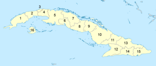
Administratively, Cuba is divided into 15 provinces and one special municipality. The current structure has been in place since August 2010, when the then-La Habana Province was divided into Artemisa Province and Mayabeque Province.

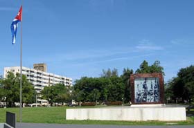
La Habana Province, formerly known as Ciudad de La Habana Province, is a province of Cuba that includes the territory of the city of Havana, the Republic's capital. The province's territory is the seat of the superior organs of the state and its provincial administration.

Santiago de Cuba Province is the second most populated province in the island of Cuba. The largest city Santiago de Cuba is the main administrative center. Other large cities include Palma Soriano, Contramaestre, San Luis and Songo-La Maya.

The Pinar del Río Province is one of the 15 provinces of Cuba. It is at the western end of the island of Cuba. The capital and largest city is Pinar del Río.
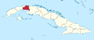
Matanzas is one of the provinces of Cuba. Major towns in the province include Cárdenas, Colón, Jovellanos and the capital of the same name, Matanzas. The resort town of Varadero is also located in this province.

Cienfuegos is one of the provinces of Cuba. The capital city of the province is also called Cienfuegos and was founded by French settlers in 1819.

Sancti Spíritus is one of the provinces of Cuba. Its capital is the identically named Sancti Spíritus. Another major city is Trinidad.

Ciego de Ávila is one of the provinces of Cuba, and was previously part of Camagüey Province. Its capital is Ciego de Ávila, which lies on the Carretera Central, and the second city is Morón, further north.

Las Tunas is one of the provinces of Cuba. Major towns include Puerto Padre, Amancio, and the capital city, Las Tunas.

Holguín is one of the provinces of Cuba, the third most populous after Havana and Santiago de Cuba. It lies in the southeast of the country. Its major cities include Holguín, Banes, Antilla, Mayarí, and Moa.

Granma is one of the provinces of Cuba. Its capital is Bayamo. Other towns include Manzanillo and Pilón.

Guanajay is a town and municipality in Artemisa Province in western Cuba, located about 58 km (36 mi) southwest of Havana. The town lies among hills.
Artemisa is a municipality and city in Cuba, formerly part of La Habana Province. According to a law approved by the Cuban National Assembly in August 2010, Artemisa became the capital city of the newly formed Artemisa Province, which comprises eight municipalities of the former La Habana Province and three from Pinar del Río. It has an area of 642.0 square kilometers and a population of over 86,444 inhabitants (2022).

Centro Habana is one of the 15 municipalities or boroughs in the city of Havana, Cuba. A chinatown - Barrio Chino - is also located in this district. It is a smaller municipality of Havana, and it has the highest population density.

Vaqueros de la Habana, commonly referred to simply as La Habana, were a baseball team in the Cuban National Series from the 1977–78 season through the 2010–11 season.
The provinces of Cuba are divided into 168 municipalities. They were defined by Cuban Law Number 1304 of July 3, 1976 and reformed in 2010 with the abrogation of the municipality of Varadero and the creation of two new provinces: Artemisa and Mayabeque in place of former La Habana Province.

Caimito is a municipality and town in Artemisa Province of Cuba. The town was founded in 1820. The municipality of Caimito del Guayabal was created in 1910, based on the previously existing (1879–1902) municipality of Guayabal in the Pinar del Río Province. Since 1976, the official name is Caimito.
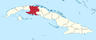
Mayabeque Province is one of two new provinces created from the former La Habana Province, whose creation was approved by the Cuban National Assembly on August 1, 2010, the other being Artemisa Province. The new provinces came in to existence on January 1, 2011.

Artemisa Province is one of the two new provinces created from the former La Habana Province, whose creation was approved by the Cuban National Assembly on August 1, 2010, the other being Mayabeque Province. The new provinces came into existence on January 1, 2011.


