Mexico City is the capital and largest city of Mexico, and the most populous city in North America. Mexico City is one of the most important cultural and financial centers in the world. It is located in the Valley of Mexico within the high Mexican central plateau, at an altitude of 2,240 meters (7,350 ft). The city has 16 boroughs or demarcaciones territoriales, which are in turn divided into neighborhoods or colonias.

Veracruz, formally Veracruz de Ignacio de la Llave, officially the Estado Libre y Soberano de Veracruz de Ignacio de la Llave, is one of the 31 states which, along with Mexico City, comprise the 32 Federal Entities of Mexico. Located in eastern Mexico, Veracruz is bordered by seven states, which are Tamaulipas, San Luis Potosí, Hidalgo, Puebla, Oaxaca, Chiapas, and Tabasco. Veracruz is divided into 212 municipalities, and its capital city is Xalapa-Enríquez.

The State of Mexico, officially just Mexico, is one of the 32 federal entities of the United Mexican States. Commonly known as Edomex to distinguish it from the name of the whole country, it is the most populous, as well as the most densely populated, state in the country.

Ismael Mario Zambada García is a Mexican drug lord, co-founder and current top leader of the Sinaloa Cartel, an international crime syndicate based in Sinaloa. Before he assumed leadership of the entire cartel, he allegedly served as the logistical coordinator for its Guzmán-Zambada organization, which has overseen the trafficking of cocaine and heroin into Chicago and other US cities by aircraft, narcosubs, container ships, go-fast boats, fishing vessels, buses, rail cars, tractor trailers, and automobiles. As of 2024, he has never been arrested or incarcerated and is the single last remaining fugitive on the list of Mexico's 37 most-wanted drug lords.

Guanajuato, officially the Free and Sovereign State of Guanajuato, is one of the 32 states that make up the Federal Entities of Mexico. It is divided into 46 municipalities and its capital city is Guanajuato.

Andrés Manuel López Obrador, also known by his initials AMLO, is a Mexican politician who is the 65th and current president of Mexico since 2018. He previously served as Head of Government of Mexico City from 2000 to 2005.
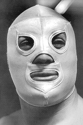
Rodolfo Guzmán Huerta, best known by his ring name El Santo, was a Mexican luchador enmascarado, actor and folk hero. He is one of the most famous and iconic Mexican luchadores, and has been referred to as one of "the greatest legends in Mexican sports". His wrestling career spanned nearly five decades, during which he became a folk hero and a symbol of justice for the common man through his appearances in luchador films and comic books telling fictionalized stories of El Santo fighting for justice. He starred or co-starred in at least 54 movies between 1958 and 1982.

Consejo Mundial de Lucha Libre Co., Ltd. is a lucha libre professional wrestling promotion based in Mexico City. The promotion was previously known as Empresa Mexicana de Lucha Libre (EMLL). Founded in 1933, it is the oldest professional wrestling promotion still in existence.

Vicente Fernández Gómez was a Mexican ranchera singer, actor and film producer. Nicknamed "Chente", "El Charro de Huentitán", "El Ídolo de México", and "El Rey de la Música Ranchera", Fernández started his career as a busker, and went on to become a cultural icon, having recorded more than 100 albums and contributing to more than 30 films. His repertoire consisted of rancheras and other Mexican classics such as waltzes.

Los Zetas was a Mexican criminal syndicate, known as one of the most dangerous of Mexico's drug cartels. They are known for engaging in brutally violent "shock and awe" tactics such as beheadings, torture, and indiscriminate murder. While primarily concerned with drug trafficking, the organization also runs profitable sex and gun rackets. Los Zetas also operate through protection rackets, assassinations, extortion, kidnappings and other illegal activities. The organization is based in Nuevo Laredo, Tamaulipas, directly across the border from Laredo, Texas. The origins of Los Zetas date back to the late 1990s, when commandos of the Mexican Army deserted their ranks and began working as the enforcement arm of the Gulf Cartel. In February 2010, Los Zetas broke away and formed their own criminal organization, rivalling the Gulf Cartel.

Joaquín Archivaldo Guzmán Loera, commonly known as "El Chapo", is a Mexican former drug lord and a former leader within the Sinaloa Cartel, an international crime syndicate. He was considered to be one of the most powerful drug traffickers in the world.

The Mexican drug war is an ongoing asymmetric armed conflict between the Mexican government and various drug trafficking syndicates. When the Mexican military intervened in 2006, the government's main objective was to reduce drug-related violence. The Mexican government has asserted that their primary focus is dismantling the cartels and preventing drug trafficking. The conflict has been described as the Mexican theater of the global war on drugs, as led by the United States federal government.
Jalisco, officially the Free and Sovereign State of Jalisco, is one of the 31 states which, along with Mexico City, comprise the 32 Federal Entities of Mexico. It is located in western Mexico and is bordered by six states, Nayarit, Zacatecas, Aguascalientes, Guanajuato, Michoacán, and Colima. Jalisco is divided into 125 municipalities, and its capital and largest city is Guadalajara.
This is a list of Mexico's 37 most-wanted drug lords as published by Mexican federal authorities on 23 March 2009. According to a BBC Mundo Mexico report, the 37 drug lords "have jeopardized Mexico national security."

The Jalisco New Generation Cartel or CJNG, is a Mexican criminal syndicate, based in Jalisco and headed by Nemesio Oseguera Cervantes. The cartel has been characterized by extreme violence and public relations campaigns. Though the CJNG is known for diversifying into various criminal rackets, drug trafficking remains its most profitable activity. The cartel has been noted for cannibalizing some victims during the training of new sicarios or members, as well as using drones and rocket-propelled grenades to attack enemies.

The National Regeneration Movement, commonly referred to by its syllabic abbreviation Morena, is a major left-wing populist political party in Mexico. As of 2023, it is the largest political party in Mexico by number of members; it has been the ruling party since 2018, and won a second term in the 2024 general election.

Nemesio Rubén Oseguera Cervantes, commonly referred to by his alias El Mencho, is a Mexican drug lord and leader of the Jalisco New Generation Cartel (CJNG), an organized crime group based in Jalisco. He is the most-wanted person in Mexico and one of the most-wanted in the U.S. The US government, as well as the Mexican government, is offering $10 million and $30 million respectively for information leading to his arrest.
The Mascogos are an Afro-descendant group in Coahuila, Mexico. Centered on the town of El Nacimiento in Múzquiz Municipality, the group are descendants of Black Seminoles escaping the threat of slavery in the United States.