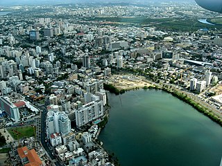
San Juan is the capital city and most populous municipality in the Commonwealth of Puerto Rico, an unincorporated territory of the United States. As of the 2020 census, it is the 57th-largest city under the jurisdiction of the United States, with a population of 342,259. San Juan was founded by Spanish colonists in 1521, who called it Ciudad de Puerto Rico.

Condado is an oceanfront, tree-lined, pedestrian-oriented upper middle to upper class community in Santurce. It is one of the forty subbarrios of Santurce in San Juan, Puerto Rico.

Old San Juan is a historic district located at the "northwest triangle" of the islet of San Juan in San Juan. Its area roughly correlates to the Ballajá, Catedral, Marina, Mercado, San Cristóbal, and San Francisco sub-barrios (sub-districts) of barrio San Juan Antiguo in the municipality of San Juan, Puerto Rico.

Río Piedras is a populous district of San Juan, and former town and municipality of Puerto Rico, which was merged with the municipality of San Juan in 1951. The district today is composed of various barrios such as Pueblo and Universidad. The historic town was founded in 1714 as El Roble, it was given municipality rights in 1823, and since 1903 it has been the home of the University of Puerto Rico's main campus, earning the popular name of Ciudad Universitaria today. The downtown and historic center of Río Piedras is officially known as the Pueblo barrio of the municipality of San Juan.
Santurce is the largest and most populated barrio of the municipality of San Juan, the capital city of Puerto Rico. With a population of 69,469 in 2020, Santurce is also one of the most densely populated areas of the main island of Puerto Rico with a population larger than most municipalities of the territory.

Milla de Oro is both the popular name given to the main central business district of San Juan and a nickname given to the sections of Juan Ponce de León Avenue and Luis Muñoz Rivera Avenue that cross Hato Rey Norte from north to south. It encompasses the largest agglomeration of corporate investment, banking and finance institutions in the Caribbean. The headquarters of Puerto Rico's largest retail investment bank, Popular, Inc., are located at Popular Center in 208 Juan Ponce de León Ave. La Milla de Oro is served by the Tren Urbano stations of Hato Rey, Roosevelt, Domenech and Piñero stations in addition to numerous bus routes with connections to Río Piedras, Plaza Las Américas, Santurce and Old San Juan.

Ocean Park is an upscale beachfront community within the barrio of Santurce, in the municipality of San Juan, Puerto Rico. It is one of the forty subbarrios of Santurce.

Campo Alegre and Alto del Cabro are two subbarrios adjacent to each other with similar characteristics in the Barrio of Santurce. They have a combined land area of 0.28 square kilometres (0.11 sq mi) and a resident population of 2,106 as of the 2000 United States Census. They are located between Expreso Baldorioty de Castro to the north, Ponce de León Avenue to the south, Cerra Street to the west and Canals and Robles Streets to the east. These subbarrios, urbanized during the 19th century, are two of the oldest sections of Santurce. The perpendicular streets running north of Ponce de León Avenue are those corresponding to old toponymical alignments of the proprietors throughout Carretera Central.
The Puerto Rico Museum of Contemporary Art, often abbreviated to MAC, is a contemporary art museum in Santurce, Puerto Rico.

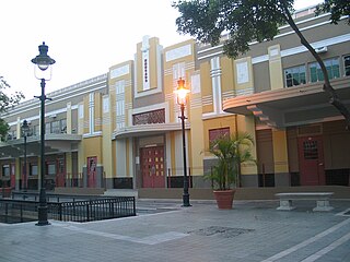
Mercado de las Carnes, also known as La Plaza de los Perros, but formally, Plaza Juan Ponce de León, was the first building in Puerto Rico to mix social and architectural elements via the pedestrian mall concept. The historic Art Deco architecture structure is located in Ponce, Puerto Rico, and dates from 1926. It was listed on the National Register of Historic Places in 1986. The Plaza was rebuilt in 1992, under the administration of Mayor Churumba. It is located in the alley connecting Mayor and Leon streets, in the block between Estrella and Guadalupe streets. The Plaza and the alley are one and the same.

Quinto is one of the 31 barrios of the municipality of Ponce, Puerto Rico. Together with Primero, Segundo, Tercero, Cuarto, and Sexto, Quinto is one of the municipality's six original urban barrios. It was organized in 1878.
Plaza del Mercado de Ponce or, formally, Plaza del Mercado Isabel Segunda, is a historic marketplace building in Ponce, Puerto Rico. It was inaugurated in 1863 by Ponce Mayor Don Luis de Quixano. Designed by famed engineer Timoteo Luberza, it occupies a city block in the Ponce Historic Zone at the grid formed by Calle Atocha, Estrella, Leon, and Castillo streets. It has room for 65 kiosks. It was originally called Plaza del Capá.
The following is a timeline of the history of the municipality of San Juan, Puerto Rico.

Ponce Servicos, formerly Plaza del Mercado Juan Bigas, is a brutalist municipal building located Ponce, Puerto Rico. It is the largest building in the municipality in terms of footprint area and the only one that occupies an entire city block. The structure was built in 1981 as a way to provide a modern, air-conditioned, structure for the merchants and shoppers of the historic but aging Plaza de Mercado Isabel II building, while the latter underwent restoration. On its opening day it was named Plaza del Mercado Juan Bigas, in honor of Juan Bigas Moulins, the Ponce businessman by that name.

Malasaña is an area in the center of Madrid, Spain. While it doesn't align with any specific administrative division, it is frequently associated with the Universidad neighborhood, the broader administrative district in which Malasaña is situated. The tourist information webpage from the Madrid City Council defines its boundaries as the streets of San Bernardo, the Gran Vía, Fuencarral and Carranza. Malasaña is associated with a creative and fringe cultural scene.

Barrio Puerto is the area located between the Plaza Wheelright and Plaza Sotomayor in the downtown area of Valparaíso, Chile.

Caguas Pueblo is a barrio and downtown area that serves the administrative center (seat) of the city and municipality of Caguas, a municipality of Puerto Rico. It is bordered by the Cagüitas River to the north and located two miles southwest of the Río Grande de Loíza. Its population in 2020 was 19,020.

Nightlife in Ponce, Puerto Rico includes government and regulatory aspects, societal and cultural attitudes, and age- and gender-centric issues relative to adult and family life after dark in the city of Ponce. It focuses on all entertainment that is available and generally more popular from the late evening into the early hours of the morning. It includes activities like parties, bands and live music, concerts, and stand-up comedies, and venues such as pubs, bars, cabarets, nightclubs, cinemas and theaters. These venues and activities are often accompanied by the serving and drinking of alcoholic beverages in addition to non-alcoholic drinks for the family. Nightlife venues often require a cover charge for admission.

Condado Beach is a large public-access beach located in Condado, a subbarrio of the barrio of Santurce in the capital municipality of San Juan in Puerto Rico.
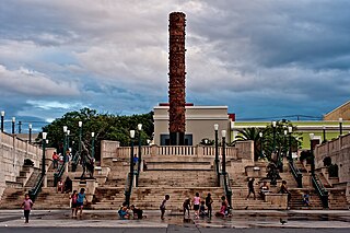
Plaza del Quinto Centenario, also Plaza del V Centenario, popularly referred to as Plaza del Tótem, is a modern square in Old San Juan, Puerto Rico, inaugurated in 1992 to commemorate the 500th anniversary of the European discovery and Spanish conquest of Puerto Rico and the Americas and the first European settlement of San Juan. The square is located between the Ballajá and Mercado neighborhoods of the San Juan Antiguo barrio of San Juan, Puerto Rico. It is located next to the Ballajá Barracks, the Puerto Rican National Gallery and the San José Church, close to El Morro and the San Juan National Historic Site.