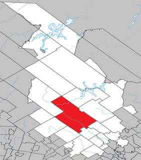
Antoine-Labelle is a regional county municipality located in the Laurentides region of Quebec, Canada. Its seat is Mont-Laurier. It is named for Antoine Labelle.
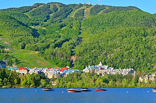
Mont-Tremblant is a city in the Laurentian Mountains of Quebec, Canada, approximately 130 kilometres (81 mi) northwest of Montreal and 140 kilometres (87 mi) northeast of Ottawa, Ontario. The current municipality with city status was formed in 2000. Mont-Tremblant is most famous for its ski resort, the Mont-Tremblant Ski Resort, which is seven kilometres from the village proper, at the foot of a mountain called Mont Tremblant.

Sainte-Agathe-des-Monts is a town in the province of Quebec, Canada, in the regional county municipality of Les Laurentides in the administrative region of Laurentides, also known as the "Laurentians" or the Laurentian Mountains. Sainte-Agathe-des-Monts borders on a lake called Lac des Sables, and is located approximately 100 kilometres (62 mi) north of Montreal.

Brébeuf is a parish municipality in the Laurentides region of Quebec, Canada, part of Les Laurentides Regional County Municipality. It is located along the Rouge River, near Mont-Tremblant.

Nominingue is a small village and municipality located 200 kilometres (120 mi) north of Montreal, Quebec, Canada, in the Laurentian Mountains. It was formerly called Lac-Nominingue, but changed name on September 16, 2000.

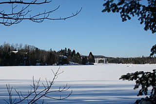
Lac-Supérieur is a municipality in the Laurentides region of Quebec, Canada, part of the Les Laurentides Regional County Municipality. It is named after Lake Superior which is located in the Laurentian Mountains, due east of Mont Tremblant Resort. The community of Lac-Supérieur is just south of the lake, which itself is ringed with cottages. The entire northern portion of the municipality is mostly undeveloped and part of the Mont-Tremblant National Park.
Harrington is a township municipality in the Laurentides region of Quebec, Canada, part of the Argenteuil Regional County Municipality. It is located in the Laurentian Mountains, about 40 kilometres (25 mi) north-west of Lachute.

Montcalm is a municipality in the Les Laurentides Regional County Municipality of Quebec southeast of Mont-Tremblant. The main population centre in Montcalm is the village of Weir.

Saint-Joseph-du-Lac is a municipality in the Laurentides region of Quebec, Canada, part of the Deux-Montagnes Regional County Municipality.
Estérel is a city in Les Pays-d'en-Haut Regional County Municipality in the Laurentides region of Quebec, Canada. The municipal territory almost entirely extends around Lake Masson, whereas the village itself is situated on the eastern shore of this lake.

Val-Morin is a municipality in the Laurentides region of Quebec, Canada, part of the Les Laurentides Regional County Municipality.

Ivry-sur-le-Lac is a village and municipality in the Laurentides region of Quebec, Canada, part of the Les Laurentides Regional County Municipality. The municipality completely encompasses Lake Manitou which is a popular cottage vacation location.

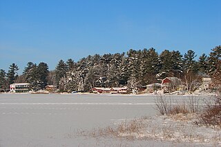
Sainte-Anne-du-Lac is a municipality and village in the Laurentides region of Quebec, Canada, part of the Antoine-Labelle Regional County Municipality.

La Minerve is a village and municipality in the Laurentides region of Quebec, Canada, part of the Les Laurentides Regional County Municipality.

Val-des-Lacs is a municipality in the Laurentides region of Quebec, Canada, part of the Les Laurentides Regional County Municipality.
Lac-du-Cerf is a municipality in the Laurentides region of Quebec, Canada, part of the Antoine-Labelle Regional County Municipality. It is located on and named after Lac du Cerf.

Saint-Aimé-du-Lac-des-Îles is a municipality in the Laurentides region of Quebec, Canada, part of the Antoine-Labelle Regional County Municipality.

Lac-des-Écorces is a municipality and village in the Laurentides region of Quebec, Canada, part of the Antoine-Labelle Regional County Municipality.
Saint-Guillaume-Nord is the southernmost unorganized territory in the Lanaudière region of Quebec, Canada, part of the Matawinie Regional County Municipality.

Lac-Pikauba is an unorganized territory in the Capitale-Nationale region of Quebec, Canada. It is a large, unpopulated, undeveloped territory that makes up two-thirds of the Charlevoix Regional County Municipality.