Lac des Mille Lacs

Last updated
Lac des Mille Lacs
Lake
Name origin:French for "Lake of a thousand lakes"
Country Canada
Province Ontario
Region Northwestern Ontario
District Thunder Bay
Tributaries
 - Primary InflowSavanne River
Elevation457 m (1,499 ft)
Coordinates 48°50′57″N90°30′38″W / 48.84917°N 90.51056°W / 48.84917; -90.51056 Coordinates: 48°50′57″N90°30′38″W / 48.84917°N 90.51056°W / 48.84917; -90.51056
Mouth Seine River
 - coordinates 48°58′46″N90°43′49″W / 48.97944°N 90.73028°W / 48.97944; -90.73028
Length30 km (19 mi)
Width20 km (12 mi)
Basin1,774.55 km2 (685 sq mi)
Area245.1 km2 (95 sq mi)
Canada Ontario location map 2.svg
Red pog.svg
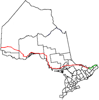
Location of Lac des Mille Lacs in Ontario.

Lac des Mille Lacs is a lake in the western part of Thunder Bay District in northwestern Ontario, Canada. It is in the Nelson River drainage basin and is the source of the Seine River. The lake lies between Ontario Highway 17 on the north and Ontario Highway 11 on the south about 100 kilometres (62 mi) west of the city of Thunder Bay.

Lake A body of relatively still water, in a basin surrounded by land

A lake is an area filled with water, localized in a basin, that is surrounded by land, apart from any river or other outlet that serves to feed or drain the lake. Lakes lie on land and are not part of the ocean, and therefore are distinct from lagoons, and are also larger and deeper than ponds, though there are no official or scientific definitions. Lakes can be contrasted with rivers or streams, which are usually flowing. Most lakes are fed and drained by rivers and streams.

Thunder Bay District District in Ontario, Canada

Thunder Bay District is a district and census division in Northwestern Ontario in the Canadian province of Ontario. The district seat is Thunder Bay.

Northwestern Ontario Secondary region in Ontario, Canada

Northwestern Ontario is a secondary region of Northern Ontario which lies north and west of Lake Superior, and west of Hudson Bay and James Bay. It includes most of subarctic Ontario. Its western boundary is the Canadian province of Manitoba, which disputed Ontario's claim to the western part of the region. Ontario's right to Northwestern Ontario was determined by the Judicial Committee of the Privy Council in 1884 and confirmed by the Canada Act, 1889 of the Parliament of the United Kingdom. In 1912, the Parliament of Canada by the Ontario Boundaries Extension Act gave jurisdiction over the District of Patricia to Ontario, thereby extending the northern boundary of the province to Hudson Bay.

Contents

Lac des Mille Lacs has an area of 245.1 square kilometres (94.6 sq mi) and a drainage basin of 1,774.55 square kilometres (685.16 sq mi). [1] The named inflows are the Savanne River and McKay Creek at Sawmill Bay at the northeast, Joe's Creek at Baril Bay at the southwest, and Inwood Creek at the north. The only outflow, at the northwest tip of the lake, is the Seine River, which flows to Rainy Lake and eventually via the Nelson River to Hudson Bay. The lake has numerous arms, named bays and named islands.

Rainy Lake lake in Ontario, Canada and Minnesota, United States

Rainy Lake is a relatively large freshwater lake straddling the border between the United States and Canada. The Rainy River issues from the west side of the lake and is harnessed to make hydroelectricity for US and Canadian locations. The sister cities of International Falls, Minnesota, and Fort Frances, Ontario, are situated on either side of the outflow of the river from the lake. Rainy Lake and Rainy River establish part of the boundary between the US state of Minnesota and the Canadian province of Ontario.

Hudson Bay A large body of saltwater in northeastern Canada

Hudson Bay is a large body of saltwater in northeastern Canada with a surface area of 1,230,000 km2 (470,000 sq mi). It drains a very large area, about 3,861,400 km2 (1,490,900 sq mi), that includes parts of southeastern Nunavut, Saskatchewan, most of Manitoba, Ontario, Quebec and indirectly through smaller passages of water to parts of North Dakota, South Dakota, Minnesota, and Montana. Hudson Bay's southern arm is called James Bay.

Roads

The lake is served by Lac des Mille Lacs Road, which connects the lake to Highway 17 near Upsala.

Ontario Highway 17 highway in Ontario

King's Highway 17, more commonly known as Highway 17, is a provincially maintained highway and the primary route of the Trans-Canada Highway through the Canadian province of Ontario. It begins at the Manitoba boundary 50 km (31 mi) west of Kenora and the main section ends where Highway 417 begins just west of Arnprior. A small disconnected signed section of the highway still remains within the Ottawa Region between County Road 29 and Grants Side Rd. This makes it Ontario's longest highway.

Upsala, Ontario Place in Canada

Upsala is an unincorporated community and geographic township in Thunder Bay District in northwestern Ontario, Canada. It is located along the Trans-Canada Highway, Highway 17, 142 kilometres (88 mi) west of Thunder Bay, part of the Unorganized Thunder Bay District.

Lac des Mille Lacs Dam

The outflow to the Seine River is controlled by the Lac des Mille Lacs Dam, owned by the Ontario Ministry of Natural Resources (OMNR) and operated by the Valerie Falls Limited Partnership (Brookfield Renewable Power). [1] The first dam at the site was built of stone by Simon James Dawson of the Department of Public Works Canada in 1873 to improve water flow for navigation to the vicinity of the Red River of the North far downstream. [2] This dam was replaced in 1926 by a timber dam to regulate water flow used for hydroelectric power production downstream on the Seine River and Rainy River. [2] The current concrete [2] structure was built in 1952 with seven sluices, each with eight logs. [1] With all logs, the maximum sill height is 457 metres (1,499 ft), and without any the minimum height is 454.6 metres (1,491 ft 6 in). [1]

Simon James Dawson Canadian politician

Simon James Dawson was a Canadian civil engineer and politician.

Red River of the North Canadian and American river

The Red River is a North American river. Originating at the confluence of the Bois de Sioux and Otter Tail rivers between the U.S. states of Minnesota and North Dakota, it flows northward through the Red River Valley, forming most of the border of Minnesota and North Dakota and continuing into Manitoba. It empties into Lake Winnipeg, whose waters join the Nelson River and ultimately flow into Hudson Bay.

Hydroelectricity electricity generated by hydropower

Hydroelectricity is electricity produced from hydropower. In 2015, hydropower generated 16.6% of the world's total electricity and 70% of all renewable electricity, and was expected to increase about 3.1% each year for the next 25 years.

The dam project is one of several in the region which has been cited by the Lac des Mille Lacs First Nation as having displaced them from their traditional territories, including the Lac des Mille Lacs 22A1 reserve on the shore of the lake, due to flooding. [3] The First Nation, which is currently dispersed throughout Northwestern Ontario rather than living on its traditional lands, has a land claim pending negotiation with the federal and provincial governments. [3]

The Lac des Mille Lacs First Nation, also known as Nizaatikoong, is a Saulteaux Ojibwe First Nation band government. The nation owns two reserves in the Thunder Bay District of Ontario, Lac des Mille Lacs 22A1 on the northeastern shore of Lac des Mille Lacs and Lac des Mille Lacs 22A2 at the junction of the Seine and Firesteel Rivers.

Aboriginal title Concept in common law of indigenous land rights persisting after colonization

Aboriginal title is a common law doctrine that the land rights of indigenous peoples to customary tenure persist after the assumption of sovereignty under settler colonialism. The requirements of proof for the recognition of aboriginal title, the content of aboriginal title, the methods of extinguishing aboriginal title, and the availability of compensation in the case of extinguishment vary significantly by jurisdiction. Nearly all jurisdictions are in agreement that aboriginal title is inalienable, and that it may be held either individually or collectively.

Tributaries

clockwise from the Seine River outflow

Related Research Articles

Kaministiquia River river in Canada

The Kaministiquia River is a river which flows into western Lake Superior at the city of Thunder Bay, Ontario. Kaministiquia (Gaa-ministigweyaa) is an Ojibwe word meaning "(river) with islands" due to two large islands at the mouth of the river. The delta has three branches or outlets, reflected on early North American maps in French as "les trois rivières" : the southernmost is known as the Mission River, the central branch as the McKellar River, and the northernmost branch as the Kaministiquia. Residents of the region commonly refer to the river as the Kam River.

Winnipeg River river in Canada

The Winnipeg River is a Canadian river which flows roughly northwest from Lake of the Woods in the province of Ontario to Lake Winnipeg in Manitoba. This river is 235 kilometres (146 mi) long from the Norman Dam in Kenora to its mouth at Lake Winnipeg. Its watershed is 106,500 square kilometres (41,100 sq mi) in area, mainly in Canada. About 29,000 square kilometres (11,000 sq mi) of the watershed is in northern Minnesota, United States.

Seine River (Ontario) river in Canada

The Seine River is a river in Kenora, Rainy River and Thunder Bay Districts in northwestern Ontario, Canada. It flows 240 kilometres (149 mi) from Lac des Mille Lacs to Rainy Lake.

Kenogami River river in Canada

The Kenogami River is a river in the James Bay drainage basin in Thunder Bay and Cochrane districts in Northern Ontario, Canada, which flows north from Long Lake near Longlac to empty into the Albany River. The river is 320 kilometres (199 mi) in length and its name means "long water" in the Cree language. A portion of the river's headwaters have been diverted into the Lake Superior drainage basin.

Bonnechere River river in Canada

The Bonnechere River is a river in the Saint Lawrence River drainage basin in Nipissing District and Renfrew County in eastern and northeastern Ontario, Canada. The river flows from Algonquin Provincial Park to the Ottawa River east and north of the town of Renfrew. The river's name is thought to come from the French "bonne chère" meaning "good cheer".

Skootamatta Lake is a lake in the Lake Ontario drainage basin in Addington Highlands, Lennox and Addington County, Ontario, Canada. It is 2.7 kilometres (1.7 mi) west of Cloyne, and Bon Echo Provincial Park is located just to the north. The lake's name is thought to come from Ojibwa words meaning "burnt shoreline".

Lake St. Joseph lake in Ontario

Lake St. Joseph is a large lake in Kenora District and Thunder Bay District in Northwestern Ontario, Canada. It is in the James Bay drainage basin and is the source of the Albany River. The east end of the lake can be reached using Ontario Highway 599 from the town of Ignace, 260 kilometres (160 mi) to the south on Ontario Highway 17. The nearest town is Pickle Lake, 30 kilometres (19 mi) north along Highway 599.

Summit Lake is a lake in Kenora District, Ontario, Canada. It is about 2.6 kilometres (1.6 mi) long and 0.8 kilometres (0.5 mi) wide, and lies at an elevation of 391 metres (1,283 ft). The lake is in the Nelson River system in the Hudson Bay drainage basin. There are no primary inflows, and the primary outflow is an unnamed creek, south towards Mud Lake, which flows into Upper Manitou Lake, and then via the Manitou River, Seine River, Rainy River, Winnipeg River and Nelson River into Hudson Bay. Highway 502 runs on the east side of the lake.

Deerock Lake is a lake in the Moira River in Tweed, Hastings County and Addington Highlands, Lennox and Addington County in Ontario, Canada.

Rainy Lake is a small lake in the Ottawa River and St. Lawrence River drainage basins in Addington Highlands, Lennox and Addington County, Ontario, Canada.

Norway Lake is a lake in the Moira River and Lake Ontario drainage basins in Addington Highlands, Lennox and Addington County, Ontario, Canada.

Montreal River (Timiskaming District) river in Timiskaming District, Ontario, Canada. Tributary of the Ottawa River.

The Montreal River is a river in Timiskaming District, Ontario, Canada. It travels 220 kilometres (137 mi) from its source at Smoothwater Lake to its mouth at Lake Timiskaming on the Ottawa River. The river is a significant source of hydroelectricity.

McKay Lake (Pic River) lake in Ontario, Canada

McKay Lake is a lake in Lake Superior drainage basin in the east part of Thunder Bay District in northwestern Ontario, Canada and the source of the Pic River. The northeast tip of the lake is 2 kilometres (1.2 mi) southwest of the Canadian National Railway mainline, 15 kilometres (9 mi) south of Ontario Highway 11 and 17 kilometres (11 mi) west of the community of Caramat.

Seine River Diversion

The Seine River Diversion is a river diversion in Rainy River District in northwestern Ontario, Canada located near Atikokan. It was built to divert water around open-pit hematite iron ore mining at Steep Rock Lake beginning in 1943.

Daisy Lake (Nipissing District)

Daisy Lake is a lake in the geographic townships of Butt and McCraney in the Unorganized South Part of Nipissing District, Ontario, Canada. The lake is in the Ottawa River drainage basin and is entirely within Algonquin Provincial Park.

Daisy Lake (Thunder Bay District)

Daisy Lake is a small lake in the Lake Superior and Lake Nipigon drainage basins in the amalgamated town of Greenstone, Thunder Bay District in northeastern Ontario, Canada.

Bobs Lake (Shallow River)

Bobs Lake is a lake in the James Bay and Abitibi River drainage basins in Cochrane District in northeastern Ontario, Canada.

Ivanhoe Lake lake in Ontario, Canada

Ivanhoe Lake is a 25-kilometre (16 mi) long, narrow lake in the Unorganized North Part of Sudbury District in Northeastern Ontario, Canada. It is on the Ivanhoe River in the James Bay drainage basin and is located 8 kilometres (5 mi) southwest of Foleyet on Ontario Highway 101. The lake is substantially encompassed by Ivanhoe Lake Provincial Park, except for some private cottages at the northeast end of the lake. The lake is known as Pishkanogami in the Anishinaabe language, and was once the site of Pishkanogami Post, a Hudson's Bay Company trading post. It was renamed Ivanhoe Lake in 1960.

Savanne, Ontario dispersed rural communityunincorporated area in Ontario, Canada

Savanne is a dispersed rural community and unincorporated area in geographic Savanne Township in the Unorganized Part of Thunder Bay District in Northwestern Ontario, Canada. The community was historically the location of a Hudson's Bay Company trading post.

References

  1. 1 2 3 4 "Lac des Mille Lacs Dam". Seine River Watershed. Retrieved 2010-08-07.
  2. 1 2 3 "History". Seine River Watershed. Retrieved 2010-08-07.
  3. 1 2 "Anishinaabe Iraq war vet completes cross-country walk with Indian Act chained to body" Archived 2013-04-29 at the Wayback Machine .. APTN National News , September 4, 2012.

  • "Lac des Mille Lacs". Geographical Names Data Base. Natural Resources Canada . Retrieved 2010-08-04.
  • "Topographic Map sheets 52B15, 52B16". Atlas of Canada . Natural Resources Canada. 2010-02-04. Archived from the original on 2009-01-22. Retrieved 2010-08-07.

The Department of Natural Resources, operating under the FIP applied title Natural Resources Canada (NRCan), is the ministry of the government of Canada responsible for natural resources, energy, minerals and metals, forests, earth sciences, mapping and remote sensing. It was created in 1995 by amalgamating the now-defunct Departments of Energy, Mines and Resources and Forestry. Natural Resources Canada (NRCan) works to ensure the responsible development of Canada's natural resources, including energy, forests, minerals and metals. NRCan also uses its expertise in earth sciences to build and maintain an up-to-date knowledge base of our landmass and resources. To promote internal collaboration, NRCan has implemented a departmental wide wiki based on MediaWiki. Natural Resources Canada also collaborates with American and Mexican government scientists, along with the Commission for Environmental Cooperation, to produce the North American Environmental Atlas, which is used to depict and track environmental issues for a continental perspective.

The Atlas of Canada is an online atlas published by Natural Resources Canada that has information on every city, town, village, and hamlet in Canada. It was originally a print atlas, with its first edition being published in 1906 by geographer James White and a team of 20 cartographers. Much of the geospatial data used in the atlas is available for download and commercial re-use from the Atlas of Canada site or from GeoGratis. Information used to develop the atlas is used in conjunction with information from Mexico and the United States to produce collaborative continental-scale tools such as the North American Environmental Atlas.