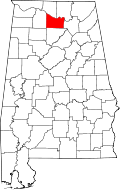
Lacey's Spring, Alabama

Last updated

Lacey's Spring, Alabama
USA Alabama location map.svg
Red pog.svg
Lacey's Spring
Usa edcp location map.svg
Red pog.svg
Lacey's Spring
Coordinates: 34°32′03″N86°36′15″W / 34.53417°N 86.60417°W / 34.53417; -86.60417
Country United States
State Alabama
County Morgan
Elevation
709 ft (216 m)
Time zone UTC-6 (Central (CST))
  Summer (DST) UTC-5 (CDT)
ZIP code
35754
Area code 256
GNIS feature ID151973 [1]

Lacey's Spring is an unincorporated community in northeastern Morgan County, Alabama, United States at the base of Brindlee Mountain. It is included in the Decatur Metropolitan Area, as well as the Huntsville-Decatur Combined Statistical Area. It is located south of Huntsville's Land within Morgan County. [2]

The community was established by three Virginia-born brothers, Hopkins, John, and Theophilus Lacy. The community took on their name and became the site for a U.S. post office in February 1831. "Lacy's Spring" became "Lacey's Spring" when the postal seal furnished by Washington officials mistakenly inserted an "e" into the name. [3]

Related Research Articles

<span class="mw-page-title-main">Morgan County, Alabama</span> County in Alabama, United States

Morgan County is a county in the north-central part of the U.S. state of Alabama. As of the 2020 census, its population was 123,421. The county seat is Decatur. On June 14, 1821, it was renamed in honor of American Revolutionary War General Daniel Morgan of Virginia. It is a prohibition or dry county, although alcohol sales are allowed in the cities of Decatur, Hartselle, and Priceville. Morgan County is included in the Decatur, AL Metropolitan Statistical Area, which is also included in the Huntsville-Decatur-Albertville, AL Combined Statistical Area. It is a part of the North, Northwest, and North-Central regions of Alabama.

<span class="mw-page-title-main">Limestone County, Alabama</span> County in the United States

Limestone County is a county of the U.S. state of Alabama. As of the 2020 census, the county's population was 103,570. Its county seat is Athens. The county is named after Limestone Creek. Limestone County is included in the Huntsville, AL Metropolitan Statistical Area.

<span class="mw-page-title-main">Decatur, Alabama</span> City in and county seat of Morgan County, Alabama

Decatur is the largest city and county seat of Morgan County in the U.S. state of Alabama. Nicknamed "The River City," it is located in northern Alabama on the banks of Wheeler Lake along the Tennessee River. The population was 57,938 at the 2020 census.

<span class="mw-page-title-main">Huntsville, Alabama</span> City in North Alabama, US

Huntsville is the most populous city in the U.S. state of Alabama. It is the county seat of Madison County with portions extending into Limestone County and Morgan County. It is located in the Appalachian region of northern Alabama.

<span class="mw-page-title-main">Eva, Alabama</span> Town in Alabama, United States

Eva is a town in Morgan County, Alabama, United States, and is included in the Decatur Metropolitan Area and the Huntsville-Decatur Combined Statistical Area. As of the 2020 census, the population of the town was 589, up from 519 in 2010. The mayor currently is Gary Livingston.

<span class="mw-page-title-main">Hartselle, Alabama</span> City in Alabama, United States

Hartselle is the second largest city in Morgan County, Alabama, United States, 13 miles (21 km) south of Decatur. It is part of the Decatur Metropolitan Area and the Huntsville-Decatur Combined Statistical Area.

<span class="mw-page-title-main">North Alabama</span> Region in Alabama

North Alabama is a region of the U.S. state of Alabama. Several geographic definitions for the area exist, with all descriptions including the nine counties of Alabama's Tennessee Valley region. The North Alabama Industrial Development Association also lists Cherokee, Cullman, Franklin, and Winston counties in the region. The Alabama Mountain Lakes Tourist Association expands the definition further to include Blount, Etowah, and Marion counties.

Danville is an unincorporated community in Morgan County, Alabama, United States.

Hulaco is an unincorporated community located in extreme southeastern Morgan County, Alabama, United States and is included in the Decatur Metropolitan Area, as well as the Huntsville-Decatur Combined Statistical Area. A post office operated under the name Hulaco from 1855 to 1904

Morgan City, also known as New Rescue, is an unincorporated community located in Morgan and Marshall counties, Alabama, United States. It is included in the Huntsville-Decatur Combined Statistical Area, as well as the Decatur Metropolitan Area.

Moulton Heights is an unincorporated community suburb of Decatur in Morgan County, Alabama, United States, and is included in the Huntsville-Decatur Combined Statistical Area, as well as the Decatur Metropolitan Area. Moulton Heights is surrounded by the city of Decatur, Alabama, and The Beltline.

Tanner is an unincorporated community in central southern Limestone County, Alabama, United States, and is included in the Huntsville-Decatur Combined Statistical Area. It lies nine miles north of the city of Decatur and the Tennessee River, and four miles south of the city of Athens.

<span class="mw-page-title-main">Huntsville–Decatur combined statistical area</span> Combined Statistical Area in the United States

The Huntsville–Decatur–Albertville, Alabama, combined statistical area is the most populated sub-region of North Alabama, and is the second largest combined statistical area in the State of Alabama after Birmingham. The Huntsville-Decatur-Albertville CSA had a total of 879,315 people in 2022 and ranks 68th in the country.

<span class="mw-page-title-main">Decatur metropolitan area, Alabama</span> Statistical Area in Alabama

The Decatur, Alabama Metropolitan Statistical Area is a moderately urban region of North-Central Alabama. The 2020 Census put the population of the metropolitan area at 152,740, of which one-third resides within the boundaries of its core city, Decatur, Alabama, It is also considered to be part of the North, Northwest, and North-Central regions of Alabama.

Alabama's 5th congressional district is a U.S. congressional district in Alabama, which elects a representative to the United States House of Representatives. It encompasses the counties of Lauderdale, Limestone, Madison, Morgan and most of Jackson. It is currently represented by Republican Dale Strong, a former Madison County Commissioner. Strong was first elected in 2022 following the retirement of Republican incumbent Mo Brooks.

<span class="mw-page-title-main">Huntsville Hospital System</span> Hospital in Alabama, United States

The Huntsville Hospital Health System, also known as Huntsville Hospital, is a public, not-for-profit hospital organization consisting of several sites and buildings originating in the downtown area of Huntsville, Alabama. The Huntsville Hospital Health System has evolved and now owns or works with several other hospitals in Alabama. It has around 13,000 employees, 2,000 nurses and 650 physicians.

<span class="mw-page-title-main">Alabama State Route 36</span> State highway in Alabama, United States

State Route 36 (SR 36) is a 44.5-mile-long (71.6 km) east–west state highway in the northern part of the U.S. state of Alabama. The western terminus of the highway is at its intersection with SR 33 at Wren, an unincorporated community in Lawrence County. The eastern terminus of the highway is at its intersection with U.S. Route 231 (US 231) at Lacey’s Spring in Morgan County.

<span class="mw-page-title-main">Neel, Alabama</span> Unincorporated community in Alabama, United States

Neel is an unincorporated community in western Morgan County, Alabama, United States. It is located south of Decatur and west of Hartselle at the 5-way stop intersection of Ironman Road, Danville Road, and Neel School Road. For statistical purposes, Neel is included within the Decatur Metropolitan Area which is, in turn, part of the Huntsville-Decatur Combined Statistical Area. A post office operated under the name Neel from 1890 to 1906. On November 29, 2016, an EF3 tornado destroyed several homes and businesses in the Neel community.

Lacy is an unincorporated community in Trinity County, Texas, United States. According to the Handbook of Texas, the community had a population of 44 in 2000. It is located within the Huntsville, Texas micropolitan area.

References

  1. "Laceys Spring". Geographic Names Information System . United States Geological Survey, United States Department of the Interior.
  2. "City Limits". randymajors.org Research Hub. Retrieved April 30, 2022.
  3. "Lacey's Spring". The Historical Marker Database.