Trinity, Alabama | |
---|---|
Coordinates: 34°36′14″N87°5′10″W / 34.60389°N 87.08611°W | |
Country | United States |
State | Alabama |
County | Morgan |
Area | |
• Total | 4.97 sq mi (12.88 km2) |
• Land | 4.97 sq mi (12.86 km2) |
• Water | 0.01 sq mi (0.02 km2) |
Elevation | 679 ft (207 m) |
Population | |
• Total | 2,526 |
• Density | 508.66/sq mi (196.40/km2) |
Time zone | UTC-6 (Central (CST)) |
• Summer (DST) | UTC-5 (CDT) |
ZIP code | 35673 |
Area code | 256 |
FIPS code | 01-76872 |
GNIS feature ID | 2406755 [2] |
Website | www |
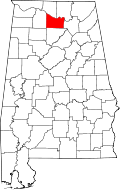
Trinity is a town in Morgan County, Alabama, United States. It is included in the Decatur Metropolitan Area and the Huntsville-Decatur Combined Statistical Area. As of the 2020 census, the population of the town was 2,526, [3] up from 2,095 in 2010. It was incorporated in 1901. [4]
Trinity was developed in the 1810s as area plantation owners built houses atop Trinity Mountain to escape the mosquito-infested lowlands. A post office operated at Trinity from 1848 to 1853. The post office reopened under the name "Trinity Station" in 1866. The town incorporated in 1901, and changed its name to simply "Trinity" two years later. [4]
Trinity is located in northwestern Morgan County across a scattered area mostly between U.S. Route 72 on the north and State Route 24 to the south (though the town's municipal boundaries extend slightly beyond each road). Decatur lies just to the east, and Wheeler Lake (part of the Tennessee River) lies to the north. The southern parts of the town are located atop Trinity Mountain, a broad ridge that rises several hundred feet above the surrounding terrain. The town is bordered to the west by Lawrence County.
According to the U.S. Census Bureau, the town has a total area of 5.0 square miles (13 km2), of which 0.008 square miles (0.021 km2), or 0.16%, are water. [1]
Census | Pop. | Note | %± |
---|---|---|---|
1880 | 142 | — | |
1900 | 191 | — | |
1910 | 198 | 3.7% | |
1920 | 243 | 22.7% | |
1930 | 208 | −14.4% | |
1940 | 249 | 19.7% | |
1950 | 342 | 37.3% | |
1960 | 454 | 32.7% | |
1970 | 881 | 94.1% | |
1980 | 1,328 | 50.7% | |
1990 | 1,380 | 3.9% | |
2000 | 1,841 | 33.4% | |
2010 | 2,095 | 13.8% | |
2020 | 2,526 | 20.6% | |
U.S. Decennial Census [5] |
At the 2000 census there were 1,841 people, 691 households, and 563 families living in the town. The population density was 508.5 inhabitants per square mile (196.3/km2). There were 728 housing units at an average density of 201.1 per square mile (77.6/km2). The racial makeup of the town was 88.00% White, 9.61% Black or African American, 1.25% Native American, 0.11% Asian, 0.16% from other races, and 0.87% from two or more races. 1.14% of the population were Hispanic or Latino of any race. [6]
Of the 691 households 38.4% had children under the age of 18 living with them, 69.9% were married couples living together, 8.5% had a female householder with no husband present, and 18.4% were non-families. 16.2% of households were one person and 6.5% were one person aged 65 or older. The average household size was 2.65 and the average family size was 2.96.
The age distribution was 25.7% under the age of 18, 6.1% from 18 to 24, 31.2% from 25 to 44, 26.1% from 45 to 64, and 10.8% 65 or older. The median age was 38 years. For every 100 females, there were 94.6 males. For every 100 females age 18 and over, there were 91.1 males.
The median household income was $54,271 and the median family income was $60,139. Males had a median income of $43,393 versus $27,552 for females. The per capita income for the town was $21,467. About 4.6% of families and 6.0% of the population were below the poverty line, including 7.7% of those under age 18 and 5.8% of those age 65 or over.
At the 2010 census there were 2,095 people, 783 households, and 647 families living in the town. The population density was 581.9 inhabitants per square mile (224.7/km2). There were 823 housing units at an average density of 228.6 per square mile (88.3/km2). The racial makeup of the town was 88.6% White, 6.7% Black or African American, 1.1% Native American, 0.2% Asian, 1.7% from other races, and 1.6% from two or more races. 3.3% of the population were Hispanic or Latino of any race. [7]
Of the 783 households 35.8% had children under the age of 18 living with them, 71.9% were married couples living together, 6.9% had a female householder with no husband present, and 17.4% were non-families. 14.6% of households were one person and 5.4% were one person aged 65 or older. The average household size was 2.68 and the average family size was 2.95.
The age distribution was 25.8% under the age of 18, 6.0% from 18 to 24, 26.2% from 25 to 44, 29.5% from 45 to 64, and 12.6% 65 or older. The median age was 40.3 years. For every 100 females, there were 100.7 males. For every 100 females age 18 and over, there were 101.9 males.
The median household income was $61,060 and the median family income was $71,818. Males had a median income of $54,250 versus $34,205 for females. The per capita income for the town was $28,628. About .9% of families and 2.7% of the population were below the poverty line, including 1.7% of those under age 18 and 3.7% of those age 65 or over.
Race | Num. | Perc. |
---|---|---|
White (non-Hispanic) | 1,873 | 74.15% |
Black or African American (non-Hispanic) | 223 | 8.83% |
Native American | 24 | 0.95% |
Asian | 5 | 0.2% |
Other/Mixed | 119 | 4.71% |
Hispanic or Latino | 282 | 11.16% |
As of the 2020 United States census, there were 2,526 people, 871 households, and 637 families residing in the town.
Morgan County is a county in the north-central part of the U.S. state of Alabama. As of the 2020 census, its population was 123,421. The county seat is Decatur. On June 14, 1821, it was renamed in honor of American Revolutionary War General Daniel Morgan of Virginia. It is a prohibition or dry county, although alcohol sales are allowed in the cities of Decatur, Hartselle, and Priceville. Morgan County is included in the Decatur, AL Metropolitan Statistical Area, which is also included in the Huntsville-Decatur-Albertville, AL Combined Statistical Area. It is a part of the North, Northwest, and North-Central regions of Alabama.
New Brockton is a town in Coffee County, Alabama, United States. At the 2020 census, the population was 1,428. The community was named for Huey E. Brock, a settler who came to the region in 1871.
Taylor is a town in Geneva and Houston counties in the U.S. state of Alabama. Taylor was first settled in the 1870s, named after an early family that helped secure the first post office. It was not incorporated until almost a century later in June 1967. It is part of the Dothan, Alabama Metropolitan Statistical Area. At the 2010 census the population was 2,375, up from 1,898 in 2000.
Pisgah is a town in Jackson County, Alabama, United States, and is included in the Huntsville-Decatur Combined Statistical Area. It incorporated in 1947. As of the 2020 census, the population of the town was 681, down from 722 in 2010. Pisgah is located atop Sand Mountain.
Woodville is a town in Jackson County, Alabama, United States. It was officially established by an act of the Alabama State Legislature on December 13, 1819, one day before Alabama became a state. It was later incorporated on May 12, 1890, but lost its charter in 1897. It reincorporated in 1912. As of the 2010 census, the population of the town is 746, down from 761 in 2000.
Hillsboro is a town in Lawrence County, Alabama, and is included in the Decatur Metropolitan Area, as well as the Huntsville-Decatur Combined Statistical Area. It was incorporated in 1899. As of the 2010 census, the population of the town is 552, down from its record high of 608 in 2000. Along with North Courtland, it is one of two majority black communities in Lawrence County out of its six populated communities as of 2010.
North Courtland is a town in Lawrence County, Alabama, United States, and is included in the Decatur Metropolitan Area, as well as the Huntsville-Decatur Combined Statistical Area. It incorporated in 1981. At the 2010 census, the population of the town was 632, down from 799 in 2000. Along with Hillsboro, it is one of two majority black communities in Lawrence County out of its six populated communities as of 2010.
Town Creek is a town in Lawrence County, Alabama, United States, and is included in the Decatur Metropolitan Area, as well as the Huntsville-Decatur Combined Statistical Area. It incorporated in March 1875. As of the 2010 census, the population of the town is 1100, down from 1216 in 2000. Since 1920, it has been the second largest town in Lawrence County after Moulton.
Athens is a city in and the county seat of Limestone County, in the U.S. state of Alabama; it is included in the Huntsville-Decatur-Albertville, AL Combined Statistical Area. As of the 2020 census, the population of the city is 25,406.
Lester is a town in Limestone County, Alabama, United States, and is included in the Huntsville-Decatur Combined Statistical Area. As of the 2010 census, the population of the town is 111, up from 107 in 2000.
Meridianville is an unincorporated community and census-designated place (CDP) in Madison County, Alabama, United States, and is included in the Huntsville-Decatur Combined Statistical Area. As of the 2020 census, the population of the CDP was 8,209.
New Hope is a city in Madison County, Alabama, United States, and is included in the Huntsville-Decatur Combined Statistical Area. The population was 2,889 at the 2020 census.
Douglas is a town in Marshall County, Alabama, United States. Douglas, a part of the Huntsville–Decatur Combined Statistical Area, had a population of 761 as of the 2020 census. The town incorporated in 1978.
Falkville is a town in Morgan County, Alabama, United States, and is included in the Decatur Metropolitan Area and Huntsville-Decatur Combined Statistical Area. As of the 2020 census, the population of the town was 1,197.
Hartselle is the second largest city in Morgan County, Alabama, United States, 13 miles (21 km) south of Decatur. It is part of the Decatur Metropolitan Area and the Huntsville-Decatur Combined Statistical Area.
Priceville is the third largest municipality in Morgan County, Alabama, United States and is included in the Decatur Metropolitan Area, as well as the Huntsville-Decatur Combined Statistical Area. The 2020 census counted a population of 3,513, up from 2,658 in 2010.
Somerville is a town in Morgan County, Alabama, United States. It is included in the Decatur Metropolitan Area and the Huntsville-Decatur Combined Statistical Area. As of the 2020 census, the population of the town was 796.
Margaret is a city in St. Clair County, Alabama, United States. At the 2020 census, the population was 5,106. As of the 2010 census, the population is 4,428, an increase of 278.8%. Margaret incorporated in 1960 and became a city in October 2011.
St. Paul or Saint Paul is a small town on the border of Decatur and Shelby counties in the U.S. state of Indiana. The population was 1,031 at the 2010 census.
Ryan Township is a township in Schuylkill County, Pennsylvania, United States. The population was 2,526 at the 2020 census.