
The Shiawassee National Wildlife Refuge is a 9,870.35 acres (39.9439 km2) National Wildlife Refuge in Saginaw County managed by the United States Fish and Wildlife Service. It is located in the central portion of the lower peninsula of the U.S. state of Michigan, approximately 25 miles (40 km) south of the Saginaw Bay in Lake Huron and five miles (8 km) south of the city of Saginaw in the county's Spaulding and James townships. It was established in 1953 to provide habitat for migratory waterfowl.
Ridgefield National Wildlife Refuge is a wildlife preserve, one of the national wildlife refuges operated by the United States Fish and Wildlife Service, located in the westernmost part of Clark County, Washington. The refuge protects more than 5,200 acres (2,100 ha) of marshes, grasslands, and woodlands. The refuge was established in 1965, in response to a need to establish vital winter habitat for wintering waterfowl with an emphasis on the dusky Canada goose whose nesting areas in Alaska were severely impacted by the violent earthquake of 1964.

Benton Lake National Wildlife Refuge is a 12,459-acre (5,042 ha) National Wildlife Refuge (NWR) in the central part of the U.S. state of Montana. It lies in northern Cascade County, 12 mi (19 km) north of the city of Great Falls, Montana. Benton Lake NWR includes shortgrass prairie and seasonal wetlands, and is nearly surrounded by the Highwood Mountains to the east, Big Belt Mountains to the south, and the Rocky Mountains to the west. Benton Lake NWR is on the western edge of the northern Great Plains and much of the shallow lake is a 6,000-acre (2,400 ha) wetland.
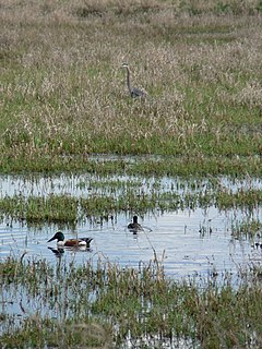
Lost Trail National Wildlife Refuge is a 8,834-acre (3,575 ha) National Wildlife Refuge of the United States located in Montana. Established in 1999, it is one of the newest National Wildlife Refuges in the U.S. and is managed by the U.S. Fish and Wildlife Service, an agency of the U.S. Department of the Interior. The refuge was originally a sprawling horse and cattle ranch dating back to the late 19th century and was known as the Lost Trail Ranch. The refuge consists of prairie and wetlands, and has a wide diversity of plant and animal species, including over 100 species of birds such as canada geese, sandhill crane, wood duck, green-winged teals and herons. Several species of grouse also inhabit the refuge. Predatory bird species such as the great horned owl and red-tailed hawk are also found here.

Sam D. Hamilton Noxubee National Wildlife Refuge is a 48,000 acres (190 km2) National Wildlife Refuge located in the U.S. state of Mississippi, in Noxubee, Oktibbeha, and Winston Counties. The refuge serves as a resting and feeding area for migratory birds and as example of proper land stewardship. Also, the refuge extensively manages land for the endangered red-cockaded woodpecker.
Huron Wetland Management District is located in the U.S. state of South Dakota and includes 17,518 acres (70.89 km2). The refuge borders the Missouri River on the east and is managed by the U.S. Fish and Wildlife Service. Huron WMD covers eight counties in east-central South Dakota. The topography of this area ranges from flat, gently rolling drift prairie to the Missouri Coteau hills in the western end of the district. The district lies in the midst of the world-renowned Prairie Pothole Region.
Lake Andes National Wildlife Refuge is located in the U.S. state of South Dakota and includes 5,638 acres (22.81 km2). The refuge is managed by the U.S. Fish and Wildlife Service and is part of the Lake Andes National Wildlife Refuge Complex. Only 938 acres (3.79 km2) is under U.S. Government ownership with the rest being an easement to ensure greater habitat protection.
Karl E. Mundt National Wildlife Refuge is located mostly in the southern part of the U.S. state of South Dakota, with a small extension into northern Nebraska, and includes 1,085 acres (4.39 km2) The refuge is a part of the Lake Andes National Wildlife Refuge Complex and is managed by the U.S. Fish and Wildlife Service. Of the land area in the district, the U.S. Government owns only 780 acres (3.15 km2), while the remaining area is managed as an easement. The refuge is closed to the public but there are excellent viewing locations from the Ft. Randle Dam on the Missouri River. The Karl E. Mundt NWR has the largest concentration of bald eagles in the lower 48 states, with over 200 eagles often spending the winter on the refuge. The refuge was named for former South Dakota Senator Karl Mundt, who was a strong supporter of the Endangered Species Act of 1966.
Lake Andes National Wildlife Refuge Complex consists of the Lake Andes National Wildlife Refuge, the Lake Andes Wetland Management District and the Karl E. Mundt National Wildlife Refuge. Altogether, 89,454 acres (362.01 km²) of U.S. Government and easement lands are managed by the complex. The complex is headquartered at Lake Andes, South Dakota and is a part of the U.S. Fish and Wildlife Service.
Sand Lake National Wildlife Refuge is located in the northeastern part of the U.S. state of South Dakota and is administered by the U.S. Fish and Wildlife Service. Created in 1935, it is a wetlands of international importance and a Globally Important Bird Area. Over 260 bird species are found in the refuge, including many migratory bird species and the world's largest breeding colony of Franklin's gulls.
Chase Lake National Wildlife Refuge is located in the U.S. state of North Dakota. The majority of the land area of the refuge has been designated as wilderness and is known as the Chase Lake Wilderness. The refuge is one of the oldest in the U.S., having been set aside in 1908. The refuge has more breeding pairs of white pelicans than any other protected area in the U.S. Chase Lake NWR is managed through Arrowwwood National Wildlife Refuge Complex and in turn, a number of other refuges and wetland management districts are managed from Chase Lake including:
Arrowwood Wetland Management District is located in the U.S. state of North Dakota. Arrowwood WMD is a part of the Arrowwood National Wildlife Refuge Complex, and is managed by the U.S. Fish and Wildlife Service. The district consists of 28 Waterfowl Production Areas, 314 Wetland easements, one easement refuge known as Johnson Lake National Wildlife Refuge and another four easements through the Farmers Home Administration, altogether totalling 28,922 acres (117 km2).
The Halfway Lake National Wildlife Refuge is located in the U.S. state of North Dakota and consists of 160 acres (0.65 km2.) The refuge is a privately owned easement refuge, managed by the U.S. Fish and Wildlife Service. The refuge is closed to the public and was established to protect habitat for migratory bird species and other animal life. Chase Lake Wetland Management District oversees the refuge, which in turn is a part of the Arrowwood National Wildlife Refuge Complex.
The Valley City Wetland Management District is located in the U.S. state of North Dakota and consists of 76,000 acres (307 km2). The wetland district is a substation of the Arrowwood National Wildlife Refuge Complex, overseen by the U.S. Fish and Wildlife Service. 82 waterfowl production areas and four separate national wildlife refuges which are privately owned are in turn managed by the wetland district as easement refuges. The wetland district is in portions of 5 counties in the Prairie Pothole Region that was created by the retreat of glaciers 12,000 years ago, during the last glacial maximum. One third of the protected lands are wetlands with the balance consisting of prairie.
The Sibley Lake National Wildlife Refuge is located in the U.S. state of North Dakota and consists of 1,077 acres (4.35 km2). Sibley Lake is a privately owned easement refuge, managed with by the U.S. Fish and Wildlife Service. The refuge was established to protect habitat for migratory bird species, white-tail deer and other mammals. Valley City Wetland Management District oversees the refuge, which in turn is a part of the Arrowwood National Wildlife Refuge Complex. Sibley Lake is a 525-acre (2.12 km2) fresh water marsh.
The Tomahawk National Wildlife Refuge is located in the U.S. state of North Dakota and consists of 440 acres (1.78 km2). Tomahawk NWR is a privately owned easement refuge, managed with by the U.S. Fish and Wildlife Service. The refuge was established to protect habitat for migratory bird species, white-tail deer and other mammals. Valley City Wetland Management District oversees the refuge, which in turn is a part of the Arrowwood National Wildlife Refuge Complex. The refuge can be accessed from North Dakota Highway 1, and is one mile (1.6 km) east of the town of Rogers, North Dakota.

Baskett Slough National Wildlife Refuge is located in northwestern Oregon, 10 miles (16 km) west of Salem in Polk County. Situated in open farmland near the eastern foothills of the Oregon Coast Range with the broad Willamette Valley and the Cascade Range to the east, elevations range from 185 to 414 feet MSL. The Willamette Valley, with its mild, rainy winter climate, is an ideal environment for wintering waterfowl. The valley was once a rich mix of wildlife habitats with extensive wetlands, meandering stream channels and vast seasonal marshes. Today, the valley is a mix of farmland and growing cities, with few areas remaining for wildlife. The Refuge consists of 1,173 acres (4.75 km²) of cropland, which provide forage for wintering geese, 300 acres (1.2 km²) of forests, 550 acres (2.2 km²) of grasslands, and 500 acres (2.0 km²) of shallow water seasonal wetlands and 35 acres (0.14 km²) of permanent open water. In 1965, Baskett Slough National Wildlife Refuge was created to help ensure some of the original habitat remained for species preservation. The refuge is managed by the U.S. Fish and Wildlife Service, an agency of the U.S. Department of the Interior.
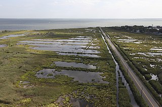
The Atchafalaya National Wildlife Refuge is located about 30 miles (48 km) west of Baton Rouge, Louisiana, and one mile (1.6 km) east of Krotz Springs, Louisiana, lies just east of the Atchafalaya River. In 1988 under the administration of Governor Foster the "Atchafalaya Basin Master Plan" was implemented that combined the 11,780-acre (4,770 ha) Sherburne Wildlife Management Area (WMA), the 15,220-acre (6,160 ha) Atchafalaya National Wildlife Refuge, and the 17,000-acre (6,900 ha) U.S. Army Corps of Engineers' Bayou Des Ourses into the Sherburne Complex Wildlife Management Area.
Seatuck National Wildlife Refuge is located in the hamlet of Islip, New York, on the south shore of Long Island. It is managed by the U.S. Fish and Wildlife Service as part of the Long Island National Wildlife Refuge Complex. The refuge consists of 196 acres (0.79 km2) bordering the Great South Bay, separated from the Atlantic Ocean only by Fire Island. Situated in a heavily developed urban area along Champlin Creek, the refuge is an oasis for many species of migratory birds and waterfowl.

The Summer Lake Wildlife Area is a 29.6-square-mile (77 km2) wildlife refuge located on the northwestern edge of the Great Basin drainage in south-central Oregon. It is administered by the Oregon Department of Fish and Wildlife. The refuge is an important stop for waterfowl traveling along the Pacific Flyway during their spring and fall migrations. The Summer Lake Wildlife Area also provides habitat for shorebirds and other bird species as well as wide variety of mammals and several fish species. The Ana River supplies the water for the refuge wetlands.


