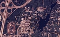
Lakeland South is a census-designated place (CDP) in King County, Washington, United States. The population was 11,574 at the 2010 census.

The Carson River is a northwestern Nevada river that empties into the Carson Sink, an endorheic basin. The main stem of the river is 131 miles (211 km) long although the addition of the East Fork makes the total length 205 miles (330 km), traversing five counties: Alpine County in California and Douglas, Storey, Lyon, and Churchill Counties in Nevada, as well as the Consolidated Municipality of Carson City, Nevada. The river is named for Kit Carson, who guided John C. Frémont's expedition westward up the Carson Valley and across Carson Pass in winter, 1844. The river made the National Priorities List (NPL) on October 30, 1990 as the Carson River Mercury Superfund site (CRMS) due to investigations that showed trace amounts of mercury in the wildlife and watershed sediments.

Lake Chelan is a narrow, 50.5 mi (81.3 km) long lake in Chelan County, north-central Washington state, U.S. It is an overdeepened lake and resembles a fjord, with an average width of 1.3 mi (2.1 km). Near its upper end, the lake surface lies more than 6,600 ft (2,000 m) below peaks less than 3 mi (4.8 km) away. Before 1927, Lake Chelan was the largest natural lake in the state in terms of both surface area and water volume. Upon the completion of Lake Chelan Dam in 1927, the elevation of the lake was increased by 21 ft (6.4 m) to its present maximum-capacity elevation of 1,100 ft (340 m).
Steelhead, or occasionally steelhead trout, is the common name of the anadromous form of the coastal rainbow trout (Oncorhynchus mykiss irideus) or Columbia River redband trout. Steelhead are native to cold-water tributaries of the Pacific basin in Northeast Asia and North America. Like other sea-run (anadromous) trout and salmon, steelhead spawn in freshwater, smolts migrate to the ocean to forage for several years and adults return to their natal streams to spawn. Steelhead are iteroparous, although survival is approximately 10–20%.

The cutthroat trout(Oncorhynchus clarkii) is a fish species of the family Salmonidae native to cold-water tributaries of the Pacific Ocean, Rocky Mountains, and Great Basin in North America. As a member of the genus Oncorhynchus, it is one of the Pacific trout, a group that includes the widely distributed rainbow trout. Cutthroat trout are popular gamefish, especially among anglers who enjoy fly fishing. The common name "cutthroat" refers to the distinctive red coloration on the underside of the lower jaw. The specific name clarkii was given to honor explorer William Clark, coleader of the Lewis and Clark Expedition.
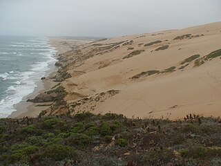
Guadalupe-Nipomo Dunes is the largest remaining dune system south of San Francisco and the second largest in the U.S. state of California. It encompasses an 18-mile (29 km) stretch of coastline on the Central Coast of California and extends from southern San Luis Obispo County to northern Santa Barbara County.

Killarney Provincial Park is a provincial park in central Ontario, Canada.

Malheur Lake is one of the lakes in the Malheur National Wildlife Refuge in Harney County in the U.S. state of Oregon. Located about 18 miles (29 km) southeast of Burns, the lake is marsh fed by the Donner und Blitzen River from the south and the Silvies River from the north. Malheur Lake periodically overflows into Mud Lake to the west and thence to Harney Lake, the sink of Harney Basin.

Nolte State Park is a 117-acre (47 ha) Washington state park located 6 miles (9.7 km) northeast of Enumclaw and just south of Cumberland at the western edge of the Cascade Mountains, with 7,174 feet (2,187 m) of shoreline on Deep Lake near the Green River Gorge. The property was a resort for many years before it was donated to the state by Minnie Nolte in the early 1970s. There are rainbow trout, coastal cutthroat trout, kokanee, crappie, and brown bullhead in the lake. The lake has a public fishing pier, beach area, and a hiking trail around the lake. The boat launch is carry-in only with limited parking. Deep Lake has a surface area of 39 acres (16 ha) and reaches a depth of 76 feet (23 m).

Harney Lake is a shallow alkali lake basin located in southeast Oregon, United States, approximately 30 miles (48 km) south of the city of Burns. The lake lies within the boundary of the Malheur National Wildlife Refuge and is the lowest point in the Blitzen Valley drainage.
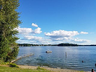
American Lake is a lake located in Lakewood, Washington at Joint Base Lewis-McChord. It is the largest natural lake in Pierce County. There are two public parks on the large lake: American Lake North Park & Marina, and Harry Todd Park. Both have lakeside beaches for swimming, fishing, or picnicking. The first also features a boat launching area; the latter has tennis courts. Fishing is a popular activity at American Lake, with cutthroat trout, largemouth bass, rainbow trout, rock bass, smallmouth bass, Sockeye salmon (kokanee) and yellow perch the most sought-after game fish. The Washington State Department of Fish and Wildlife regularly monitors the health of the fishery and stocks favored species regularly.
There are three Manistique Lakes in the Upper Peninsula of Michigan. The lakes include North Manistique Lake, Big Manistique Lake, and South Manistique Lake. The towns surrounding the lakes are Curtis, Germfask, and Helmer. The lakes are known for vacationing and fishing. They are also in close proximity to other natural sights such as the Great Lakes, rivers, and smaller lakes as well as tourist attractions including the Canada–US border, the Soo Locks, Mackinac Island, parks, and museums.

The Humboldt Wildlife Management Area (WMA) is a wildlife management area in the U.S. state of Nevada, encompassing the salt marshes at the terminus of the Humboldt River.
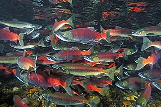
The kokanee salmon, also known as the kokanee trout, little redfish, silver trout, kikanning, Kennerly's salmon, Kennerly's trout, or Walla, is the non-anadromous form of the sockeye salmon. There is some debate as to whether the kokanee and its sea-going relative are separate species; geographic isolation, failure to interbreed, and genetic distinction point toward a recent divergence in the history of the two groups. The divergence most likely occurred around 15,000 years ago when a large ice melt created a series of freshwater lakes and rivers across the northern part of North America. While some members of the salmon and trout family (salmonids) went out to sea (anadromous), others stayed behind in fresh water (non-anadromous). The separation of the sockeye and the kokanee created a unique example of sympatric speciation that is relatively new in evolutionary terms. While they occupy the same areas and habitats during the breeding season, when ocean-going sockeye salmon return to freshwater to spawn, the two populations do not mate with each other in some regions, suggesting speciation.

Anderson Lake is a 57-acre (23 ha) body of water lying 1.5 miles (2.4 km) west of Chimacum in Jefferson County, Washington. It is located in Section 9, Township 29N, Range 1W. Anderson Lake reaches a depth of 29 feet (8.8 m) at its deepest point and has a water volume of 1,228 acre-feet (1,515,000 m3). The lake drains into Chimacum Creek and Port Townsend Bay. It is surrounded by Anderson Lake State Park. The lake's fish population includes lake-reared rainbow trout, that carry over to a second season from the initial spring fishery.
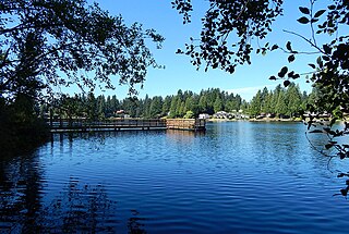
Fivemile Lake is located in southern King County, Washington in the Lakeland South census-designated place. It has a popular park on its eastern bank. Fivemile Lake is one of several lakes in Lakeland South, including Lake Killarney, Lake Geneva, and Trout Lake.
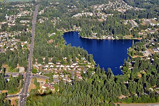
Star Lake is located in southern King County, Washington in the Lakeland North census-designated place. Interstate 5 runs just to the west of the lake.

Lake Geneva is a lake located in southern King County, Washington, in the Lakeland South census-designated place. While largely surrounded by residential private property, it is also home to the popular Lake Geneva Park. It is located just across the street from Lake Killarney. Lake Geneva is one of several lakes in Lakeland South, including Lake Killarney, Fivemile Lake, and Trout Lake.

Trout Lake is a small lake in King County, Washington in the Lakeland South census designated place. Trout Lake is one of several lakes in Lakeland South, including Fivemile Lake, Lake Killarney and Lake Geneva.

Echo Lake is located in Shoreline, Washington, a suburb adjacent to Seattle. Echo Lake Park sits on its northeastern corner.
