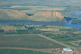
Kununurra is a town in far northern Western Australia located at the eastern extremity of the Kimberley approximately 45 kilometres (28 mi) from the border with the Northern Territory. Kununurra was initiated to service the Ord River Irrigation Scheme. Its language is Miriwoong.
The Kimberley is the northernmost of the nine regions of Western Australia. It is bordered on the west by the Indian Ocean, on the north by the Timor Sea, on the south by the Great Sandy and Tanami deserts in the region of the Pilbara, and on the east by the Northern Territory.

The Paroo River, a series of waterholes, connected in wet weather as a running stream of the Darling catchment within the Murray–Darling basin, is located in the South West region of Queensland and Far West region of New South Wales, Australia. It is the home of the Paarkantji people.

The freshwater crocodile, also known as the Australian freshwater crocodile, Johnstone's crocodile or the freshie, is a species of crocodile endemic to the northern regions of Australia. Unlike their much larger Australian relative, the saltwater crocodile, freshwater crocodiles are not known as man-eaters, although they bite in self-defence, and brief, nonfatal attacks have occurred, apparently the result of mistaken identity.

Lake Argyle is Western Australia's largest and Australia's second largest freshwater man-made reservoir by volume. The reservoir is part of the Ord River Irrigation Scheme and is located near the East Kimberley town of Kununurra. The lake flooded large parts of the Shire of Wyndham-East Kimberley on the Kimberley Plateau about 80 kilometres (50 mi) inland from the Joseph Bonaparte Gulf, close to the border with the Northern Territory.

The Ord River is a 651-kilometre long (405 mi) river in the Kimberley region of Western Australia. The river's catchment covers 55,100 square kilometres (21,274 sq mi).

The Shire of Wyndham East Kimberley is one of the four local government areas in the Kimberley region of northern Western Australia, covering an area of 117,514 square kilometres (45,372 sq mi) at Western Australia's northeastern corner. The Shire's seat of government was originally in Wyndham but now in the town of Kununurra, which is home to over half of the Shire's permanent population of around 7,000, while a council office is located at Wyndham.
Ord River Hydro Power Station is a hydroelectric power station operated by Pacific Blue. It is located on the Ord River in Western Australia. It has four turbines, with a generating capacity of 30 megawatts (40,000 hp) of electricity.

Mornington Sanctuary, formerly Mornington Station, is a 3,582 km2 (1,383 sq mi) nature reserve in the Kimberley region of north-west Western Australia. It contains the Mornington Wilderness Camp and is owned and managed by the Australian Wildlife Conservancy (AWC). It lies in the Pentecost subregion of the Central Kimberley Bioregion.

Dunham River is a river in the Kimberley region of Western Australia.
Lake Gore is a seasonal and semi-permanent freshwater lake in the Goldfields-Esperance region of Western Australia located approximately 24 km (15 mi) west of Esperance. It is an important site for waterbirds.
The Lakes Argyle and Kununurra Ramsar Site comprises an extensive system of artificial freshwater reservoirs, with their associated permanent wetlands, formed by damming the Ord River in the eastern part of the Kimberley region of northern Western Australia. The reservoirs include Lake Argyle and Lake Kununurra. There are numerous endemic plants and a rich fauna. The 1,500 km2 (580 sq mi) site was designated a wetland of international importance under the Ramsar Convention on 7 June 1990, making it Ramsar Site 478.

The Ord River floodplain is the floodplain of the lower Ord River in the Shire of Wyndham-East Kimberley, in the Kimberley region of northern Western Australia. It lies within the Victoria Bonaparte IBRA bioregion and contains river, seasonal creek, tidal mudflat and floodplain wetlands, with extensive stands of mangroves, that support saltwater crocodiles and many waterbirds. It is recognised as an internationally important wetland area, with 1,384 square kilometres (534 sq mi) of it designated on 7 June 1990 as Ramsar Site 477 under the Ramsar Convention on Wetlands.

Argyle Downs is a pastoral lease and cattle station located about 120 kilometres (75 mi) south east of Kununurra in the Kimberley region near the border of Western Australia and Northern Territory. It is operated by the Consolidated Pastoral Company.
Ivanhoe or Ivanhoe Station is a pastoral lease and cattle station located just north of Kununurra in the Kimberley region of Western Australia. Founded in 1893 by the Durack brothers, station is presently owned by the Consolidated Pastoral Company.

The Hunter Estuary Wetlands comprise a group of associated wetlands at and near the mouth of the Hunter River in the city of Newcastle, New South Wales, Australia. The wetlands are part of Hunter Wetlands National Park. 30 km2 of the wetlands have been recognised as being of international importance by designation under the Ramsar Convention. It was listed on 21 February 1984 as Ramsar site 287. A larger area of the wetlands has been identified by BirdLife International as an Important Bird Area (IBA). The wetlands are recognised as the most important area in New South Wales for waders, or shorebirds.
The North Victorian Wetlands, also known as the Kerang Wetlands, comprise an extensive series of over 100 freshwater, brackish and saline lakes and swamps on the floodplain of the Loddon River where it enters the Murray valley, in the vicinity of the town of Kerang, in northern Victoria, south-eastern Australia. They are important for a variety, and sometimes large numbers, of waterbirds.

The Ord Irrigation Area Important Bird Area is an area of land used for irrigated agriculture along the Ord River in the vicinity of the town of Kununurra in the Kimberley region of north-western Australia. It has been identified by BirdLife International as a 220 km2 Important Bird Area (IBA) for its significance for birds, especially estrildid finches.
The Miriwoong people, also written Miriwung and Miriuwung, are an Aboriginal Australian people of the Kimberley region of northern Western Australia.
The Gajirrawoong people, also written Gadjerong, Gajerrong and other variations, are an Aboriginal Australian people of the Northern Territory, most of whom now live in north-eastern Western Australia.