A caldera is a large cauldron-like hollow that forms shortly after the emptying of a magma chamber in a volcanic eruption. An eruption that ejects large volumes of magma over a short period of time can cause significant detriment to the structural integrity of such a chamber, greatly diminishing its capacity to support its own roof, and any substrate or rock resting above. The ground surface then collapses into the emptied or partially emptied magma chamber, leaving a large depression at the surface. Although sometimes described as a crater, the feature is actually a type of sinkhole, as it is formed through subsidence and collapse rather than an explosion or impact. Compared to the thousands of volcanic eruptions that occur over the course of a century, the formation of a caldera is a rare event, occurring only a few times within a given window of 100 years. Only eight caldera-forming collapses are known to have occurred between 1911 and 2018, with a caldera collapse at Kīlauea, Hawaii in 2018. Volcanoes that have formed a caldera are sometimes described as "caldera volcanoes".

Japan is an archipelagic country comprising a stratovolcanic archipelago over 3,000 km (1,900 mi) along the Pacific coast of East Asia. It consists of 14,125 islands. The four main islands are Hokkaido, Honshu, Kyushu, and Shikoku. The other 14,120 islands are classified as "remote islands" by the Japanese government. The Ryukyu Islands and Nanpō Islands are south and east of the main islands.

Akan Mashu National Park is a national park located on the island of Hokkaidō, Japan. Along with Daisetsuzan National Park, these are the two oldest national parks in Hokkaidō. The park was established December 4, 1934.

Lake Mashū is an endorheic crater lake formed in the caldera of a potentially active volcano. It is located in Akan Mashu National Park on the island of Hokkaido, Japan. It has been called the clearest lake in the world.

Shikotsu-Tōya National Park is a national park in the western part of the island of Hokkaidō, Japan. Named after the volcanic caldera lakes of Lake Shikotsu and Lake Tōya, it has a total area of 993.02 square kilometers. The popular hot spring resorts of Noboribetsu south of the lake and Jozankei North of the lake are also within the park.

Lake Towada is the largest crater lake in Honshū island, Japan. Located on the border between Aomori and Akita prefectures, it lies 400 meters (1,800 ft) above sea level and is 327 m (1,073 ft) deep, drained by the Oirase river. With a surface area of 61.1 km2 (23.6 sq mi), Towada is Japan's 12th largest lake; its bright blue color is due to its great depth. The lake is roughly circular, with two peninsulas extending from its southern shore approximately one-third into the center of the lake. The lake is a popular tourist destination.

The North Island Volcanic Plateau is a volcanic plateau covering much of central North Island of New Zealand with volcanoes, lava plateaus, and crater lakes. It contains the Taupō caldera complex, Ōkataina caldera complex and Tongariro Volcanic Centre resulting in it being currently the most frequently active and productive area of silicic volcanism on Earth. New Zealand is part of the Pacific Ring of Fire.

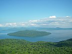
Lake Tōya is a volcanic caldera lake in Shikotsu-Toya National Park, Abuta District, Hokkaidō, Japan. It is part of "Toya Caldera and Usu Volcano Global Geopark" which joins in Global Geoparks Network. The stratovolcano of Mount Usu lies on the southern rim of the caldera. The lake is nearly circular, being 10 kilometers in diameter from the eastwest and 9 kilometers from the northsouth. The town of Tōyako comprises most of the area surrounding the lake and the town of Sōbetsu is located on the eastern side.

Lake Tazawa is a caldera lake in the city of Semboku, Akita Prefecture, northern Japan. It is the deepest lake in Japan at 423 metres (1,388 ft). The area is a popular vacation area and several hot spring resorts can be found in the hills above the lake. Akita Prefecture's largest ski area, Tazawako Ski Area [ja], overlooks the lake.

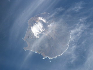
Onekotan is an uninhabited volcanic island located near the northern end of the Kuril Islands chain in the Sea of Okhotsk in the northwest Pacific Ocean. Its name is derived from the Ainu language for "large village”. It is the second largest island, after Paramushir, in the northern subgroup of the Kurils. It is administratively included in the Severo-Kurilsky District of Sakhalin oblast, Russia.

The Daisetsuzan Volcanic Group is a volcanic group of peaks arranged around the 2 kilometres (1.2 mi) wide Ohachi-Daira caldera in Hokkaidō, Japan. In the Ainu language it is known as Nutapukaushipe, Nutaku Kamushupe, or Optateske. These peaks are the highest in Hokkaidō. The group lends its name to the Daisetsuzan National Park in which the volcanic group is located.
Ketoy is an uninhabited volcanic island located in the centre of the Kuril Islands chain in the Sea of Okhotsk in the northwest Pacific Ocean. Its name is derived from the Ainu language for "skeleton" or "bad".
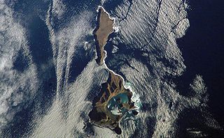
Ushishir is a collective name for two uninhabited volcanic islands and several reefs, all being parts of an eponymous partially submerged volcano, located in the centre of the Kuril Islands chain in the Sea of Okhotsk in the northwest Pacific Ocean. Its name is derived from the Ainu language for "hot spring".

Lake Shikotsu is a caldera lake in Chitose, Hokkaidō, Japan. It is a part of the Shikotsu-Toya National Park.

A lake island is any landmass within a lake. It is a type of inland island. Lake islands may form a lake archipelago.

Aso caldera is a geographical feature of Kumamoto Prefecture, Japan. It stretches 25 kilometers north to south and 18 kilometers east to west. The central core "Aso Gogaku" is the five major mountains in the area. Aso valley (Asodani) runs along the northern base of Mount Aso and Nango valley (Nangodani) along the south. According to research of caldera sediment, lakes used to exist in these valleys. The dried up lake areas have come to be called Old Aso Lake, Kugino Lake, and Aso Valley Lake. The Kikuchi, Shirakawa and Kurokawa rivers now drain the caldera.

Kurile Lake is a caldera and crater lake in Kamchatka, Russia. It is also known as Kurilskoye Lake or Kuril Lake. It is part of the Eastern Volcanic Zone of Kamchatka which, together with the Sredinny Range, forms one of the volcanic belts of Kamchatka. These volcanoes form from the subduction of the Pacific Plate beneath the Okhotsk Plate and the Asian Plate.

Hyalessa maculaticollis is a species of cicada found in Northeast Asia in the order Hemiptera.

The Chivyrkuisky Isthmus is a broad land bridge that connects the island-like mountainous part of the Svyatoy Nos peninsula to the eastern shore of Lake Baikal. The isthmus and the "island" are part of the Zabaykalsky (Trans-Baikal) National Park of the Republic of Buryatia.
Mount Mokoto is a dormant volcano in Akan Mashu National Park, in eastern Hokkaido. It is located on the north side of Lake Kussharo and straddles the towns of Koshimizu, Teshikaga, Ozora, and Bihoro.