Lake Narungazi

Last updated
Lake Narungazi
Lac Narungazi
Burundi physical map.svg
Red pog.svg
Lake Narungazi
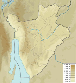
Location Kirundo Province of Burundi
Coordinates 2°32′11″S30°00′11″E / 2.5365°S 30.0031°E / -2.5365; 30.0031

Lake Narungazi (French : Lac Narungazi), or Lake Narugazi, Lake Narunganzi, is a lake in the Commune of Ntega in Kirundo Province of Burundi.

Contents

Location

Lake Narungazi is in the Commune of Ntega, Kirundo Province, to the east of Mugendo. It is west of Lake Rwihinda and south of Lake Nagitamo. [1] It covers an area of 61 hectares (150 acres) in a valley at an altitude of 1,380 metres (4,530 ft) bordered by the collines Nyange–Kiriringanire and Kanyarwe–Mwunguko, which reach an altitude of 1,452 metres (4,764 ft). [2]

Environment

Lake Narungazi is in the Nyavyamo cyperus papyrus swamp which extends east from the Akanyaru River and includes Lake Nagitamo and Lake Rwihinda. [3] Upstream of Lake Narungazi, the Nyavyamo marsh is used for the cultivation of sorghum. [4] The southern branch of Lake Narungazi, between the collines of Kanyago the east and Mugendo to the west, extends through Narungazi marsh, which is used for cultivation of rice up to the edge of the water, apart from some fragments of Typha domingensis and some tufts of Phragmites . [5]

Lake Gacamirindi dried up in 2004, a period of normal precipitation. [6] Lake Narungazi and Lake Nagitamo now supply water to Lake Gacamirindi through an canal connecting the lakes through the Rugege marsh. [4] There is a risk that this canal will lower the water level of Lake Rwihinda, particularly during periods of drought, when water no longer flows from the Akanyaru River to Lake Rwihinda. [7]

Conservation

Lake Narungazi is part of the Protected Aquatic Landscape of the North (French : Paysage Aquatique Protégé du Nord), a 162.42 square kilometres (62.71 sq mi) complex of 8 permanent freshwater lakes including lakes Rweru, Cohoha, Rwihinda, Kanzigiri, Gacamirindi, Nagitamo, Narungazi and Mwungere as well as marshes, that form part of the Nile Basin. [8] These lakes are dominated by small Tilapia and Oreochromis species. They have been the site of largescale invasions of water hyacinth, which has greatly decreased production and reduced fish stocks, as well as crowded out native vegetation. Burundi has taken little effort to remove the invasive species. [8]

In October 2013 it was reported that an entrepreneur had introduced new species of fish to the lake. The local people thought ha had added harmful chemicals to the water to protect the fish, and they were no longer allowed to use the water. An official from the Ministry of the Environment said the proper permits had been issued. The entrepreneur denied adding anything other than a ton of tilapia from Lake Rweru to the water. It seemed from the report that there were some restrictions on fishing for the first year. [9]

Related Research Articles

<span class="mw-page-title-main">Kirundo Province</span> Province of Burundi

Kirundo Province is one of the eighteen provinces of Burundi, in north of the country bordering Rwanda. The economy is mostly based on agriculture, with a dispersed population and few sizable communities. Before 1970 large parts of the province were forested. Migrants from the south then cleared much of the vegetation to create agricultural land, and Kirundo became the breadbasket of Burundi. The civil war from 1993 to 2005 caused agricultural output to drop by more than half. Sice then, lack of farm inputs, poor infrastructure and shortages of water have caused widespread poverty.

<span class="mw-page-title-main">Nyabarongo River</span> River in Rwanda

The Nyabarongo is a major river in Rwanda, part of the upper headwaters of the Nile. With a total length of 351 km (218 mi), it is the longest river entirely in Rwanda. It is extended 421 km (262 mi) in Lake Rweru including a 69 km (43 mi) upper course of Kagera River before joining into Ruvuvu River to form the Kagera River. The river begins its course at the confluence of the rivers Mbirurume and Mwogo in the South West of the country. These two rivers themselves begin in Nyungwe Forest, and are considered by some to be the most distant source of the Nile. From its start, Nyabarongo flows northward for 85 km, and forms the border between the Western and Southern Provinces. At the confluence with the river Mukungwa, the river changes course and flows eastward for 12 km, then to a more South Eastern course for the last 200 km. For the longest stretch of this course, the river serves as the boundary between the Northern and Southern Provinces, then between the City of Kigali and the Southern Province, and lastly between the City of Kigali and the Eastern Province.

The commune of Bugabira is a commune of Kirundo Province in northern Burundi. The capital is Bugabira. There are health centers at Muyange and Ruhehe.

Busoni is a commune of Kirundo Province in northern Burundi. The seat lies at Busoni.

The Commune of Bwambarangwe is a commune of Kirundo Province in northern Burundi.

<span class="mw-page-title-main">Commune of Kirundo</span> Commune in Kirundo Province, Burundi

The Commune of Kirundo is a commune of Kirundo Province in northern Burundi.

The commune of Ntega is a commune of Kirundo Province in northern Burundi.

The Pasteur River is a river in Quebec, Canada, to the north of the lower Saint Lawrence River. It is a tributary of the Aux Rochers River in the Lac-Walker territory of Côte-Nord. For most of its length it flows through the proposed Lake Walker National Park. The lower section of the river includes the 21 kilometres (13 mi) long Lake Pasteur.

The Akanyaru Multipurpose Dam, is a planned dam across the Akanyaru River, at the international border between Rwanda and Burundi. The dam will create a reservoir with storage capacity of 333,000,000 cubic metres (1.1759784018×10¹⁰ cu ft). The water is expected to supply drinking water to an estimated 614,200 people in both countries. The reservoir is also expected to provide irrigation water to an estimated 12,474 hectares (30,820 acres) of agricultural land in Burundi and Rwanda, benefitting an estimated 24,948 farmers. The dam will also host Akanyaru Hydroelectric Power Station, with generating capacity of 14.5 MW (19,400 hp).

Lake Mwungere is a lake in the Kirundo Province of Burundi.

The Murehe Forest is an area of forest in the north of the Kirundo Province of Burundi. It is protected by the Murehe Reserve, part of the Lacs du Nord Aquatic Landscape.

<span class="mw-page-title-main">Protected Aquatic Landscape of the North</span>

The Protected Aquatic Landscape of the North, also called the Northern Protected Waterway or Northern Protected Waterscape, is a protected area in Kirundo Province, Burundi. It covers eight lakes in the north of the province, and a forest. It was designated Ramsar site no. 2149 in March 2014.
<span class="mw-page-title-main">Lake Kanzigiri</span> Lake in Burundi

Lake Kanzigiri is a lake in the Kirundo Province of Burundi.

<span class="mw-page-title-main">Lake Rwihinda</span> Lake in Burundi

Lake Rwihinda, also known as the Lac aux Oiseaux is a lake in the Kirundo Province of Burundi. It is home to diverse migratory birds, which are the main tourist attraction in the region. However, despite being protected, it is under threat from encroaching agriculture in this very poor region.

Kabanga is a village and a colline in the Commune of Busoni, Kirundo Province, Burundi.

Lake Gitamo, or Lake Nagitamo is a lake in the Kirundo Province of Burundi.

Lake Gacamirindi, or Lake Gacamirinda, is a lake in the Kirundo Province of Burundi.

Ntega is a large village, the seat of the Commune of Ntega, Kirundo Province in the north of Burundi.

Mugendo is a village in the Commune of Ntega, Kirundo Province in the north of Burundi.

Kabanga is a small market town and colline (municipality) in the Commune of Busoni, Kirundo Province in northern Burundi. It lies at the juncture of routes 63 and 314, 14.8 kilometres (9.2 mi) northeast of Busoni, and 10.9 kilometres (6.8 mi) south of Nyagisozi.

References

  1. Way: Lac Narungazi.
  2. Decret N°100-114.
  3. Nzigidahera, Fofo & Misigaro 2005, p. 32.
  4. 1 2 Nzigidahera, Fofo & Misigaro 2005, p. 44.
  5. Nzigidahera, Fofo & Misigaro 2005, p. 63.
  6. Nzigidahera, Fofo & Misigaro 2005, p. 29.
  7. Nzigidahera, Fofo & Misigaro 2005, p. 62.
  8. 1 2 USAID/Burundi 2022, p. 17.
  9. Maishatse 2013.

Sources