Long Valley Caldera is a depression in eastern California that is adjacent to Mammoth Mountain. The valley is one of the Earth's largest calderas, measuring about 20 mi (32 km) long (east-west), 11 mi (18 km) wide (north-south), and up to 3,000 ft (910 m) deep.

Volcanic cones are among the simplest volcanic landforms. They are built by ejecta from a volcanic vent, piling up around the vent in the shape of a cone with a central crater. Volcanic cones are of different types, depending upon the nature and size of the fragments ejected during the eruption. Types of volcanic cones include stratocones, spatter cones, tuff cones, and cinder cones.
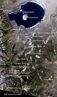
The Mono–Inyo Craters are a volcanic chain of craters, domes and lava flows in Mono County, Eastern California. The chain stretches 25 miles (40 km) from the northwest shore of Mono Lake to the south of Mammoth Mountain. The Mono Lake Volcanic Field forms the northernmost part of the chain and consists of two volcanic islands in the lake and one cinder cone volcano on its northwest shore. Most of the Mono Craters, which make up the bulk of the northern part of the Mono–Inyo chain, are phreatic volcanoes that have since been either plugged or over-topped by rhyolite domes and lava flows. The Inyo volcanic chain form much of the southern part of the chain and consist of phreatic explosion pits, and rhyolitic lava flows and domes. The southernmost part of the chain consists of fumaroles and explosion pits on Mammoth Mountain and a set of cinder cones south of the mountain; the latter are called the Red Cones.

Newberry Volcano is a large active shield-shaped stratovolcano located about 20 miles (32 km) south of Bend, Oregon, United States, 35 miles (56 km) east of the major crest of the Cascade Range, within the Newberry National Volcanic Monument. Its highest point is Paulina Peak. The largest volcano in the Cascade Volcanic Arc, Newberry has an area of 1,200 square miles (3,100 km2) when its lava flows are taken into account. From north to south, the volcano has a length of 75 miles (121 km), with a width of 27 miles (43 km) and a total volume of approximately 120 cubic miles (500 km3). It was named for the geologist and surgeon John Strong Newberry, who explored central Oregon for the Pacific Railroad Surveys in 1855. The surrounding area has been inhabited by Native American populations for more than 10,000 years.

Mount Mazama is a complex volcano in the state of Oregon, United States, in a segment of the Cascade Volcanic Arc and Cascade Range. Most of the mountain collapsed following a major eruption approximately 7,700 years ago. The volcano is in Klamath County, in the southern Cascades, 60 miles (97 km) north of the Oregon–California border. Its collapse formed a caldera that holds Crater Lake. The mountain is in Crater Lake National Park. Mount Mazama originally had an elevation of 12,000 feet (3,700 m), but following its climactic eruption this was reduced to 8,157 feet (2,486 m). Crater Lake is 1,943 feet (592 m) deep, the deepest freshwater body in the US and the second deepest in North America after Great Slave Lake in Canada.

Nemrut is a dormant volcano in Eastern Turkey, close to Lake Van. The volcano is named after King Nimrod who is said to have ruled this area in about 2100 BC.

Lake Ilopango is a crater lake which fills an 8 by 11 km volcanic caldera in central El Salvador, on the borders of the San Salvador, La Paz, and Cuscatlán departments. The caldera, which contains the second largest lake in the country and is immediately east of the capital city, San Salvador, has a scalloped 100 m (330 ft) to 500 m (1,600 ft) high rim. Any surplus drains via the Jiboa River to the Pacific Ocean. An eruption of the Ilopango volcano is considered a possible source for the extreme weather events of 535–536. The local military airbase, Ilopango International Airport, has annual airshows where international pilots from all over the world fly over San Salvador City and Ilopango lake.

Quetrupillán is a stratovolcano located in Araucanía Region of Chile. It is situated between Villarrica and Lanín volcanoes, within Villarrica National Park. Geologically, Quetrupillán is located in a tectonic basement block between the main traces of Liquiñe-Ofqui Fault and Reigolil-Pirihueico Fault.
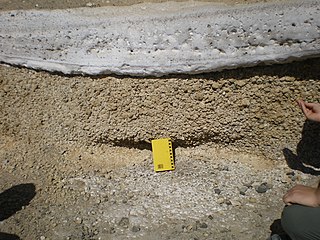
Phreatomagmatic eruptions are volcanic eruptions resulting from interaction between magma and water. They differ from exclusively magmatic eruptions and phreatic eruptions. Unlike phreatic eruptions, the products of phreatomagmatic eruptions contain juvenile (magmatic) clasts. It is common for a large explosive eruption to have magmatic and phreatomagmatic components.
Sollipulli is an ice-filled volcanic caldera and volcanic complex, which lies southeast of the small town of Melipeuco in the La Araucanía Region, Chile. It is part of the Southern Volcanic Zone of the Andes, one of the four volcanic belts in the Andes chain.

The volcanoes of east-central Baja California are located on the Baja California Peninsula near the Gulf of California, in the state of Baja California Sur, in Mexico.
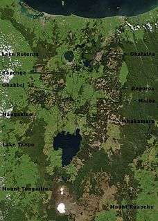
Lake Taupō, in the centre of New Zealand's North Island, is the caldera of a large rhyolitic supervolcano called the Taupō Volcano. This huge volcano has produced two of the world's most violent eruptions in geologically recent times.
The Poroto Mountains are a mountain range in the Mbeya Region of Tanzania. They are located east of the city of Mbeya. The Poroto Mountains are a northwestward extension of the Kipengere Range, and part of the Southern Highlands. The Poroto mountains are volcanic in origin, part of the geological Rungwe Volcanic Province.
Calabozos is a Holocene caldera in central Chile's Maule Region. Part of the Chilean Andes' volcanic segment, it is considered a member of the Southern Volcanic Zone (SVZ), one of the three distinct volcanic belts of South America. This most active section of the Andes runs along central Chile's western edge, and includes more than 70 of Chile's stratovolcanoes and volcanic fields. Calabozos lies in an extremely remote area of poorly glaciated mountains.
Ol Doinyo Eburru is an active complex of volcanoes in the Great Rift Valley, Kenya to the northwest of Lake Naivasha. It is being exploited for geothermal energy. Soysambu Conservancy is located to the north of the massif, between Lake Elmenteita to the east and Lake Nakuru to the west.
Menengai Forest is an urban forest situated within the town of Nakuru in Kenya. The Menengai Crater is within the forest. It was gazetted as a forest in the 1930s. It is surrounded by residential areas of Milimani Estate in the South, Ngachura and Bahati in the East, Solai in the North and Olo-Rongai in the West. Various Government of Kenya facilities have been hived off from the forest; these include the Kenya Broadcasting Corporation and the Nakuru G.K Prison. There is also a geothermal exploration project by the Geothermal Development Company inside the Menengai Crater floor.

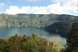
Sete Cidades Massif is a stratovolcanic complex, referring to a polygenetic volcano and caldera, located in western part of the island of São Miguel, in the Portuguese archipelago of the Azores. More recognizable for the Lagoa das Sete Cidades at its centre, the volcanic complex includes centuries of geomorphological structures that include lava domes, cones, lava flows and maar geomorphology that have marked its history.

Kurile Lake is a caldera and crater lake in Kamchatka, Russia. It is also known as Kurilskoye Lake or Kuril Lake. It is part of the Eastern Volcanic Zone of Kamchatka which, together with the Sredinny Range, forms one of the volcanic belts of Kamchatka. These volcanoes form from the subduction of the Pacific Plate beneath the Okhotsk Plate and the Asian Plate.

Ticsani is a volcano in Peru northwest of Moquegua and consists of two volcanoes that form a complex. "Old Ticsani" is a compound volcano that underwent a large collapse in the past and shed 15–30 cubic kilometres (3.6–7.2 cu mi) of mass down the Rio Tambo valley. Today an arcuate ridge remains of this edifice. "Modern Ticsani" is a complex of three lava domes which were emplaced during the Holocene. Two large eruptions took place during the Holocene, producing the so-called "Grey Ticsani" and "Brown Ticsani" deposits; the last eruption occurred after the 1600 eruption of neighbouring Huaynaputina. The volcano is seismically active and features active hot springs and fumaroles; since 2015 the volcano is monitored by the Peruvian government.

Ubinas is an active stratovolcano in the Moquegua Region of southern Peru, approximately 60 kilometres (37 mi) east of the city of Arequipa. Part of the Central Volcanic Zone of the Andes, it rises 5,672 metres (18,609 ft) above sea level. The volcano's summit is cut by a 1.4-kilometre-wide (0.87 mi) and 150-metre-deep (490 ft) caldera, which itself contains a smaller crater. Below the summit, Ubinas has the shape of an upwards-steepening cone with a prominent notch on the southern side. The gently sloping lower part of the volcano is also known as Ubinas I and the steeper upper part as Ubinas II; they represent different stages in the volcano's geological history.