Lake Tyler

Last updated
Lake Tyler
Lake Tyler East/West
Lake Tyler East.jpg
View of Lake Tyler East from a Park on State Highway 64
Relief map of Texas.png
Red pog.svg
Lake Tyler
Usa edcp relief location map.png
Red pog.svg
Lake Tyler
Location Smith County, Texas, United States
Coordinates 32°12′40″N95°10′28″W / 32.21111°N 95.17444°W / 32.21111; -95.17444
Type reservoir
Primary inflows Caney Creek
Primary outflows Prairie and Mud Creeks
Built1949 (West) and 1966 (East)
Surface area4,714 acres (1,908 ha)
Average depth17.6 ft (5.4 m)
Max. depth40 ft (12 m)
Surface elevation375 ft (114 m) [1]
An aerial view of the city of Tyler, the namesake of Lake Tyler Tyler Texas aerial 2018.jpg
An aerial view of the city of Tyler, the namesake of Lake Tyler

Lake Tyler (West) is a man-made public water reservoir located south-east of Tyler, Texas, in eastern Smith County. While named after the town of Tyler (pop. 104,789), Lake Tyler is closer to the smaller cities of Whitehouse (pop. 7660) and Arp (pop. 970). Lake Tyler resides in the northern Neches River watershed, [2] and was formed after the completion of Whitehouse Dam on Prairie Creek in 1949. [3] The design engineer of the dam was T.C. Forrest (Now Forrest and Cotton, Inc.), and the earthfill dam was constructed to be 4,708 feet long, standing at a maximum height of 50 feet, with a width of 20 feet and a drainage area of 48 square miles, according to the Texas Water Development Board. Lake Tyler is found in the Piney Woods ecoregion of eastern Texas, a temperate coniferous forest hosting a great amount of biodiversity. Just to the east of the lake lies Lake Tyler East, created after the completion of Mud Creek Dam in early 1967. [4] Just over a year later, in May 1968, the two lakes were connected by a canal to combine the water supply. [5] Together, the two lakes have a combined safe yield of over 30 million gallons per day, [6] and combine to encompass an approximate surface area of 4,714 acres, all maintained and operated by the city of Tyler to provide a source of public water to several surrounding communities. [7]

Contents

Hydrology

Lake Tyler was made by impounding Prairie Creek, which then becomes a tributary of Mud Creek. Mud Creek then serves as a headwater for the larger Angelina River, which itself is a tributary of the Neches River. [8] The lake has an average depth of 17.6 feet, [9] with a maximum depth of 40 feet. [10] The elevation of the top water level is just over 375 feet above sea level with a 2-foot variation depending on water availability. [11] The surface area of Lake Tyler is slightly less than that of its eastern counterpart, covering an average of 2,224 acres [12] and a maximum of 2,400 acres. [13] In 2011, a serious drought lowered the storage of the reservoir from the normal 80 thousand acre-feet to 50 thousand acre-feet, and did not return to normal levels until 2014. [14] Floods are not as common in the region, and the most severe flood the reservoir sustained in recorded history was in July 2007, when the surface area increased to around 90 thousand acre-feet, equating to three feet of water rising above the flood pool level, causing damage to local buildings on the edge of the lake. [15] [16] A study of the sedimentation data in Texas in 1959 found the reservoir to be losing capacity at a rate of 103 acre-feet per year due to sediment deposition.

Physicochemical characteristics

A study on the trophic classification of Texas reservoirs in 2020 from the Texas Commission on Environmental Quality found that Lake Tyler had a mean chlorophyll-a (Chl-a) level of 11.72 μg/L, a mean Secchi disk depth of 1.46 meters, and a mean total phosphorus level of 0.02 mg/L. These characteristics classify Lake Tyler as a eutrophic lake. [17] The table below, displays the levels of other nutrients in Lake Tyler as collected by the Environmental Protection Agency in a study on the quality of water in Texas reservoirs.

Lake Tyler Designated Uses and Numeric Criteria
LocationAquatic Life UseWater Supply

Use

Cl

(mg/L)

SO4−2

(mg/L)

TDS

(mg/L)

Dissolved Oxygen

(mg/L)

pH Range

(SU)

Temperature

(°F)

Lake TylerHigh usePublic Water Supply -

Municipal, Industrial, Domestic

50502005.06.0-8.593

Lake Tyler is of a relatively low salinity, with excellent levels for all solutes, aside from a slightly lower than average dissolved oxygen level as identified by the EPA. Furthermore, in a 2013 review of reservoir-specific chlorophyll-a criteria for Texas reservoirs, the EPA analyzed 40 measurements of Chl-a and determined that the results were adequate for maintaining the reservoirs designated uses, approving the criteria. A 2013 volumetric and sedimentation survey from the Texas Water Development Board collected core samples were taken of the sediment beneath Lake Tyler, with the goal of collecting a sample that contained both the current sediment and the sediment present before impoundment of water. In these samples, a pattern emerged where the first section of sediment was a dark silty loam with a high water content. Although the depth of the silty loam differed upon the location where the sample was collected, the core would always shift to a lighter sandy clay with organics present, indicating that the deeper sediment was likely present from before water was impounded to create the lake.

Ecology

Flora

Coontail - Ceratophyllum demersum Ceratophyllum demersum 2010-8-14 RioMontoro SierraMadrona.jpg
Coontail - Ceratophyllum demersum

A vegetation survey was conducted in 2019 by Texas Parks and Wildlife to identify the local flora at Lake Tyler. The following table identifies the aquatic vegetation present in their findings, along with the surface area in acres.

Surface Area (acres) of Vegetation by Year of Survey
Coontail Pondweed Watermilfoil Spatterdock American Lotus Panicum hemitomon Bulrush Water Primrose Bladderwort Buttonbush White Water Lilly Alligatorweed
2012nana37427nanananana50
2015702na23na174na4nanana4
20194717na417572na64477na

Fauna

The surrounding forest area of Lake Tyler is an avid location for bird watchers, as there have been over 220 species of birds recorded on site. Among these are the Wood Duck, the Red-headed Woodpecker, the Pileated Woodpecker, the Eastern Bluebird, the Summer Tanager, the Blue Grosbeak, along with several others. [18] Lake Tyler is also stocked with a wide variety of fish, including Blue Catfish, Channel Catfish, White Bass, Spotted Bass, Largemouth Bass, Black Crappie, and White Crappie. Prey species for these sport fish included Threadfin Shad, Gizzard Shad, and Bluegill. [19]

Nuisance species

The American Lotus Flower - Nelumbo lutea Nelumbo lutea.jpg
The American Lotus Flower - Nelumbo lutea

The only nuisance species currently present in Lake Tyler is pondweed. On July 6 of 2021, the city of Tyler proposed treatment for 0.07 acres of pondweed through mechanical means. [20] The city of Tyler also proposed treatment for 50 acres of water hyacinth in the connected Lake Tyler East through chemical means, using a 2,4-D Amine formulation. [21] Although there is currently no presence of invasive species, vegetative surveys in 2012 and 2015 from TPWD identified the presence of 50 acres and 4 acres of the invasive Alligatorweed, respectfully.

Climate

Lake Tyler and the surrounding areas are located near the western border of the South Central Plains (Pineywoods) ecoregion. [22] This area is known for a humid subtropical climate with hot summers and short, chilly winters. [23] There is an average rainfall of 46.7" per year, and 248 days out of the year have sunny weather. The first freeze usually occurs in the month of November, and an average of 1" of snow falls per year, usually in the late winter. [24]

Lake Use

Lake Tyler is primarily used as a means to provide a source of public water to the local community for years to come. [25] However, the city of Tyler also maintains three recreational areas around Lake Tyler; Camp Tyler, Lake Tyler Petroleum Club, and the Lake Tyler Marina. Camp Tyler is a 350-acre outdoor learning center that serves as an educational area for the children of Tyler, the Petroleum Club offers cabins, venues, and a secondary marina. The main marina offers a boat launch, as well as an RV park with several activities for visitors of all age groups. [26]

Surrounding land use and effects

Pileated Woodpecker - Dryocopus pileatus Pileated Woodpecker on a Branch.jpg
Pileated Woodpecker - Dryocopus pileatus

Several industries are present in the area around Lake Tyler, including Zee Mechanical Solutions, East Texas Canopy, and W-S Companies. There are also numerous local farms and ranches nearby, many of these passed down through generation of families. Despite the large amount of agricultural presence, it seems as though there is no current concern about runoff of nutrients affecting the lake[ citation needed ].

Channel Catfish - Ictalurus punctatus Ictalurus punctatus.jpg
Channel Catfish - Ictalurus punctatus

Related Research Articles

Lake Kickapoo is a reservoir located on the North Fork Little Wichita River in the Red River Basin of Archer County, Texas. It is neighbored by Archer City, Texas and Wichita Falls, Texas which reside within the Central Great Plains ecoregion.

<span class="mw-page-title-main">Neches River</span> Stream in East Texas

The Neches River begins in Van Zandt County west of Rhine Lake and flows for 416 miles (669 km) through the piney woods of east Texas, defining the boundaries of 14 counties on its way to its mouth on Sabine Lake near the Rainbow Bridge. Two major reservoirs, Lake Palestine and B. A. Steinhagen Reservoir are located on the Neches. The Angelina River is a major tributary with its confluence at the north of Lake B. A. Steinhagen. Tributaries to the south include Village Creek and Pine Island Bayou, draining much of the Big Thicket region, both joining the Neches a few miles north of Beaumont. Towns and cities located along the river including Tyler, Lufkin, and Silsbee, although significant portions of the Neches River are undeveloped and flow through protected natural lands. In contrast, the lower 40 miles of the river are a major shipping channel, highly industrialized, with a number of cities and towns concentrated in the area including Beaumont, Vidor, Port Neches, Nederland, Groves, and Port Arthur.

<span class="mw-page-title-main">Brazos River</span> River in Texas

The Brazos River, called the Río de los Brazos de Dios by early Spanish explorers, is the 14th-longest river in the United States at 1,280 miles (2,060 km) from its headwater source at the head of Blackwater Draw, Roosevelt County, New Mexico to its mouth at the Gulf of Mexico with a 45,000-square-mile (116,000 km2) drainage basin. Being one of Texas' largest rivers, it is sometimes used to mark the boundary between East Texas and West Texas.

<span class="mw-page-title-main">Brady Creek Reservoir</span> Reservoir in McCulloch County, Texas

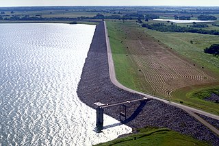
Brady Creek Reservoir is a reservoir on Brady Creek in McCulloch County, Texas in the United States. The lake is about 3 miles west of downtown Brady, Texas. The dam and lake are managed by the City of Brady. The reservoir was officially impounded in 1963. The reservoir is also sometimes called Brady Reservoir or Brady Lake. The dam for Brady Creek Reservoir is 8,400 ft. long and 104 ft. high and has a storage capacity of 30,430 acre-Ft.

<span class="mw-page-title-main">Lake Waco</span> Reservoir in Texas, United States

Lake Waco is a man-made reservoir located on the west side of Waco, in McLennan County, Texas. It provides water to several cities in the Waco Metropolitan Statistical Area, including Waco, Bellmead, Hewitt, Robinson, Woodway and others in the Cross Timbers and Prairies ecoregion of Texas. Lake Waco was formed by a dam built on the Bosque River basin. The lake has 79,000 acre-feet (97,000,000 m3) of water and is managed by the U.S. Army Corps of Engineers.

<span class="mw-page-title-main">Lavon Lake</span> Reservoir in Collin County, Texas

Lavon Lake is a freshwater reservoir located in southeast Collin County, Texas, on the East Fork of the Trinity River near Wylie, off State Highway 78. It is commonly called Lake Lavon for commercial and recreational purposes, but Lavon Lake is its official name according to the U.S. Army Corps of Engineers. It was originally called Lavon Reservoir.

Lake Holbrook is a lake in Wood County, Texas, United States. It is roughly 3 miles northwest of the city of Mineola, Texas, which has a population of 4,823 according to he 2020 census. Lake Holbrook is a part of the Sabine River basin and sit on Keys Creek.

<span class="mw-page-title-main">Twin Buttes Reservoir</span> Water supply reservoir in southwest of San Angelo, Texas

Twin Buttes Reservoir is an artificial lake located about 6 mi (9.7 km) southwest of the city of San Angelo, Texas, and immediately upstream from Lake Nasworthy. Construction on Twin Buttes Dam to form the reservoir was completed in 1963. The dam is an unusual one – it dams the Middle and South Concho Rivers separately; a stabilization channel runs between the two sides of the lake. Water levels fell significantly during the 2010–13 Southern United States drought and remained low into 2014.

<span class="mw-page-title-main">Amistad Dam</span> Dam in Texas / Acuña Municipality, Coahuila

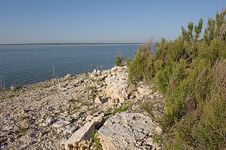
Amistad Dam is a major embankment dam across the Rio Grande between Texas, United States, and Coahuila, Mexico. Built to provide irrigation water storage, flood control, and hydropower generation, it is the largest dam along the international boundary reach of the Rio Grande. The dam is over 6 miles (9.7 km) long, lies mostly on the Mexican side of the border, and forms Amistad Reservoir. It supplies water for irrigation in the Rio Grande Valley, 574 miles (924 km) upstream of the Rio Grande's mouth on the Gulf of Mexico at Brownsville, Texas/Matamoros, Tamaulipas.

<span class="mw-page-title-main">Lake Palestine</span>

Lake Palestine is a freshwater reservoir in northeast Texas, created for industrial, municipal, and recreational purposes.

The exposed strata at the surface in and around Wichita Falls are the products of one ancient period of deposition with a modest amount of recent and modern alteration. In all cases, the strata are products of terrigenous (non-marine) environments dominated by fluvial depositional and erosional systems.

Kirby Lake is a 740-acre man-made reservoir located on the south side of Abilene, Texas, just east of Highway 83, in the northeastern portion of Taylor County. Kirby Lake is within the Brazos River Basin, meaning that Cedar Creek, which feeds Kirby Lake, eventually feeds into the Brazos River. Kirby Lake resides in the Red Prairies portion of the Central Great Plains ecoregion. Management is under the City of Abilene.

<span class="mw-page-title-main">Lake Bardwell</span> Reservoir in Texas, United States of America

Lake Bardwell is a lake in Ellis County, Texas. The lake was constructed by the United States Army Corps of Engineers in 1965. Lake Bardwell is not used for military operations, and is accessible to the public for recreational purposes; it has seven facilities, but the state public ramp is closed.

<span class="mw-page-title-main">Lake Cypress Springs</span> Reservoir in northeast Texas

Lake Cypress Springs is a 3,461-acre (1,401 ha) reservoir in northeast Texas, approximately 90 miles (140 km) east of Dallas, Texas. The lake is used for recreational, municipal, and industrial purposes. The lake is regularly monitored by a lake patrol, which enforces wake zones, fishing licenses, boat dock rules, and boating. Lake Cypress Springs has 20 subdivisions and around 850 waterfront homes. In 2011, Lake Cypress Springs was rated one of "The 10 Best Lakes to Call Home" according to D Magazine.

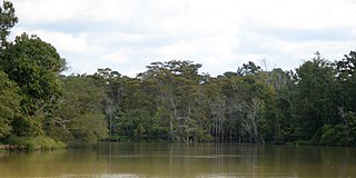
Lake Tyler East is a reservoir on Mud Creek in the Neches River Basin of Smith County, Texas. It is neighbored by Whitehouse, Texas that is encompassed by Tyler, Texas which resides within the South Central Plains ecoregion.

<span class="mw-page-title-main">Lake Leon (Texas)</span> Lake in Texas

Lake Leon is located in Eastland County and was created by the State Board of Water Engineers by impounding the Leon River. In reference to Abilene, Texas with a population of around 125,000, it is 68 miles east, and in reference to Eastland, Texas with a population of around 4,000, it is 10 miles southeast. Lake Leon is found in the Brazos River and in the Cross Timbers ecoregion, more specifically the Cross Timbers Grand Prairie ecoregion.

Navarro Mills Lake is located in Navarro County, Texas. It is located 20 miles west of Corsicana, and about 35 miles east of Waco.

Lake Childress, sometimes Childress Lake, is a lake near Childress, Texas.

Lake Nacogdoches is a lake located about 10 miles west of the city of Nacogdoches, Texas on Loco Bayou dam. Loco Bayou dam is connected to the Angelina River because it is a Tributary, of which is also a part of the Neches River basin.

References

  1. "Lake Tyler (Neches River Basin)". Texas Water Development Board. Retrieved 2022-11-04.
  2. "Introduction to the Texas Clean Rivers Program - Angelina & Neches River Authority". www.anra.org. Retrieved 2021-11-29.
  3. "Lake Tyler (Neches River Basin) | Texas Water Development Board". www.twdb.texas.gov. Retrieved 2021-11-28.
  4. ushist. "USHistory Research Blog". USHistory Research Blog. Retrieved 2021-11-29.
  5. "Lake Tyler (Neches River Basin) | Texas Water Development Board". www.twdb.texas.gov. Retrieved 2021-11-29.
  6. "Lake Tyler/Lake Tyler East | Tyler, TX". www.cityoftyler.org. Retrieved 2021-11-29.
  7. "Lake Tyler (Neches River Basin) | Texas Water Development Board". www.twdb.texas.gov. Retrieved 2021-11-29.
  8. "Lake Tyler (Neches River Basin) | Texas Water Development Board". www.twdb.texas.gov. Retrieved 2021-11-29.
  9. "Lake Tyler/Lake Tyler East | Tyler, TX". www.cityoftyler.org. Retrieved 2021-11-29.
  10. Lake-Tyler.com. "Lake Tyler Texas: Location, access, maps, fishing, lodging, weather, photos, HGTV Dream Home". www.lake-tyler.com. Retrieved 2021-11-29.
  11. "Water Data For Texas". www.waterdatafortexas.org. Retrieved 2021-11-29.
  12. East-Texas.com. "East Texas Lakes". www.east-texas.com. Retrieved 2021-11-29.
  13. "Lake Tyler/Lake Tyler East | Tyler, TX". www.cityoftyler.org. Retrieved 2021-11-29.
  14. "Water Data For Texas". waterdatafortexas.org. Retrieved 2021-11-29.
  15. "Water Data For Texas". waterdatafortexas.org. Retrieved 2021-11-29.
  16. "Homeowners Cleaning Up After Lake Floods". www.kltv.com. 8 July 2007. Retrieved 2021-11-29.
  17. Florida, USF Water Institute, School of Geosciences, University of South. "Learn More: Trophic State Index (TSI) - Lake County Water Atlas - Lake.WaterAtlas.org". www.lake.wateratlas.usf.edu. Retrieved 2021-11-29.{{cite web}}: CS1 maint: multiple names: authors list (link)
  18. "Lake Tyler Loop — Texas Parks & Wildlife Department". tpwd.texas.gov. Retrieved 2021-11-29.
  19. "Lake Tyler Survey Report". tpwd.texas.gov. Retrieved 2021-11-29.
  20. "Aquatic Vegetation, Approved Treatment Proposals". tpwd.texas.gov. Retrieved 2021-11-29.
  21. "Aquatic Vegetation, Approved Treatment Proposals". tpwd.texas.gov. Retrieved 2021-11-29.
  22. "Texas ecoregion map". Native Plant Society of Texas. 2019-02-08. Retrieved 2021-11-30.
  23. Lake-Tyler.com. "Lake Tyler Texas weather, current weather conditions,weather forecast,weather radar,weather records". www.lake-tyler.com. Retrieved 2021-11-30.
  24. TylerTexasOnline.com. "Tyler Weather & Climate". www.tylertexasonline.com. Retrieved 2021-11-30.
  25. "Lake Tyler/Lake Tyler East | Tyler, TX". www.cityoftyler.org. Retrieved 2021-11-30.
  26. "Lake Tyler Recreational Areas". Visit Tyler. 2020-05-29. Retrieved 2021-11-30.