
Rhode Island, officially the State of Rhode Island and Providence Plantations, is a state in the New England region of the United States. It is the smallest U.S. state by area and the seventh least populous, but it is also the second most densely populated. The state takes its short name from Rhode Island; however, most of the state is located on the mainland. The state has land borders with Connecticut to the west, Massachusetts to the north and east, and the Atlantic Ocean to the south via Rhode Island Sound and Block Island Sound. It also shares a small maritime border with New York. Providence is the state capital and most populous city in Rhode Island.

Providence County is the most populous county in the U.S. state of Rhode Island. As of the 2010 census, the county's population was 626,667, or 59.5% of the state's population. Providence County contains the city of Providence, the state capital of Rhode Island and the county's most populous city, with an estimated 179,335 residents in 2018. Providence County is included in the Providence-Warwick, RI-MA Metropolitan Statistical Area, which in turn constitutes a portion of the greater Boston-Worcester-Providence, MA-RI-NH-CT Combined Statistical Area. In 2010, the center of population of Rhode Island was located in Providence County, in the city of Cranston.
Route 4, also known as the Colonel Rodman Highway, is a 10.37-mile-long (16.69 km) numbered state highway located in Washington County and southern Kent County, Rhode Island, United States. The route is a major north–south freeway in the southern Providence metropolitan area, directly linking Providence with eastern Washington County, the beaches of Narragansett and South Kingstown, and the city of Newport. Route 4 begins as a two-lane divided highway at an intersection with U.S. Route 1 in the town of North Kingstown, becoming a limited-access freeway after 1.89 miles (3.04 km). The route has four numbered interchanges before terminating in the city of Warwick, where the northbound lanes merge into Interstate 95 (I-95).

This is a list of properties and districts listed on the National Register of Historic Places in Rhode Island. As of May 29, 2015, there are more than 750 listed sites in Rhode Island. All 5 of the counties in Rhode Island have listings on the National Register.

The Blackstone Canal was a waterway linking Worcester, Massachusetts, to Providence, Rhode Island through the Blackstone Valley via a series of locks and canals during the early 19th century.
Lake Washington or Washington Lake may refer to:
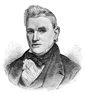
Nathan Fellows Dixon was a United States Senator from Rhode Island. Born in Plainfield, Connecticut, he attended Plainfield Academy and graduated from the College of Rhode Island and Providence Plantations at Providence in 1799. He studied law, was admitted to the bar in 1801 and commenced practice in New London County, Connecticut. He moved to Westerly, Rhode Island in 1802 and continued the practice of law, and also engaged in banking, serving as president of the Washington bank of Westerly from 1829 until his death.

The Moosup Valley State Park Trail is a rail trail located on the railbed of a former New York, New Haven and Hartford Railroad line in the New England towns of Plainfield and Sterling in Windham County, Connecticut. The line ran from 1898 until 1968. The rail line was abandoned in the late 1960s, and was designated by the state as a multi-use trail in 1987. The trail is owned and operated by the Connecticut Department of Energy and Environmental Protection.

Rhode Island's 2nd congressional district is a congressional district in southern and western Rhode Island. The district is currently represented by Democrat James Langevin, who has represented the district since January 2001.
Henry Smith was the fifth Governor of Rhode Island from October 15, 1805 to May 7, 1806.

The Providence metropolitan area is a region extending into eight counties in two states, and is the 38th largest metropolitan area in the United States. Anchored by the city of Providence, Rhode Island, it has an estimated population of 1,622,520, exceeding that of Rhode Island by slightly over 60%. The area covers almost all of Rhode Island. Thirty-eight of the 39 municipalities in the state are included. Only Westerly is not. The Providence Metropolitan Statistical Area also extends into southern Massachusetts with an average population density of 2300 per mi2. Its Gross Metropolitan Product is the country's 42nd largest at $64.7 billion, just above the Gross State Product of the entire state of Hawaii. Since 2006, the Providence metropolitan area has been officially included in the Greater Boston Combined Statistical Area (CSA), the sixth-largest CSA in the country, with over eight million residents.

The East Bay Bike Path is a 14.5-mile (23.3 km) paved rail trail in Rhode Island. The path begins at Providence and India Point Park, crosses the Seekonk River via the George Redman Linear Park and Washington Bridge and continues southeast to Bristol along the shoreline of Narragansett Bay. The path passes through the city of East Providence, the hamlet of Riverside, and the towns of Barrington and Warren. It is part of the East Coast Greenway, a 3,000-mile system of trails connecting the Canada–US border in Maine to Key West. and provides access to Haines State Park, Brickyard Pond (Barrington), and Colt State Park. It is used annually by 1.1 million people.
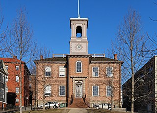
The Old State House on College Hill in Providence, Rhode Island, known also as Providence Sixth District Court House,Providence Colony House, Providence County House, or Rhode Island State House is located on 150 Benefit Street. It is a brick Georgian-style building completed largely in 1762. It was used as the meeting place for the colonial and state legislatures for 149 years.

The following is an alphabetical list of articles related to the U.S. state of Rhode Island and Providence Plantations.

Providence is the capital and most populous city of the state of Rhode Island and is one of the oldest cities in the United States. It was founded in 1636 by Roger Williams, a Reformed Baptist theologian and religious exile from the Massachusetts Bay Colony. He named the area in honor of "God's merciful Providence" which he believed was responsible for revealing such a haven for him and his followers. The city is situated at the mouth of the Providence River at the head of Narragansett Bay.

Wallum Lake is a 322-acre (1.30 km2) lake that lies in Burrillville, Providence County, Rhode Island and Douglas, Worcester County, Massachusetts. It is adjacent to Douglas State Forest and Wallum Lake Park.

Miscoe Lake is a reservoir in Cumberland, Providence County, Rhode Island. It is about 0.8 miles (1.3 km) long and the northern tip of the lake lies in Wrentham, Norfolk County, Massachusetts. At normal levels it has a surface area of 49 acres (20 ha). It has also been known as Grants Mills Pond and Miso Meadow Pond.

William R. Walker & Son was an American architectural firm in Providence, Rhode Island, active during the years 1881 to 1938. It included partners William Russell Walker (1830–1905), William Howard Walker (1865–1922), and later, William Russell Walker II (1889–1936).
The 2014 United States House of Representatives elections in Rhode Island were held on November 4, 2014 to elect the two U.S. Representatives from the state of Rhode Island, apportioned according to the 2010 United States Census. The elections coincided with the elections of other federal and state offices, including an election to the U.S. Senate and the election for governor.

