
Kealia Pond National Wildlife Refuge is a coastal salt marsh along the south-central coast of Maui, Hawaiʻi. The refuge is located between the towns of Kihei and Maalaea, on both sides of North Kihei Road, Route 31. The wetland is also a 691-acre (2.80 km2) bird sanctuary, home to 30 species of waterfowl, shorebirds, and migratory ducks, including the ʻaukuʻu and the endangered āeʻo and ʻalae keʻokeʻo. Kealia Pond was selected as a wildlife refuge in 1953, protecting an initial 300 acres (1.2 km2) of land. The refuge joined the National Wildlife Refuge System in 1992.

Elkhorn Slough is a 7-mile-long (11 km) tidal slough and estuary on Monterey Bay in Monterey County, California. It is California's second largest estuary and the United States' first estuarine sanctuary. The community of Moss Landing and the Moss Landing Power Plant are located at the mouth of the slough on the bay.
The Blackbeard Island National Wildlife Refuge is a 5,618 acres (2,274 ha) National Wildlife Refuge located in McIntosh county in Georgia. The refuge was established to provide a nature and forest preserve for aesthetic and conservation purposes.

Los Peñasquitos Marsh Natural Preserve and Lagoon is a coastal marsh in San Diego County, California, United States situated at the northern edge of the City of San Diego, forming the natural border with Del Mar, California. This bar-built estuary, previously called The Soledad Lagoon, divides a colony of the endangered Pinus torreyana on a narrow coastal strip. Three streams empty into the lagoon: Carroll Creek, Carmel Creek, Los Peñasquitos Creek with a total drainage basin area of 95 square miles.
Classification of wetlands has been a problematical task, with the commonly accepted definition of what constitutes a wetland being among the major difficulties. A number of national wetland classifications exist. In the 1970s, the Ramsar Convention on Wetlands of International Importance introduced a first attempt to establish an internationally acceptable wetland classification scheme.
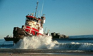
The North Cape oil spill took place on January 19, 1996, when the tank barge North Cape and the tug Scandia grounded on Moonstone Beach in South Kingstown, Rhode Island, after the tug caught fire in its engine room during a winter storm. An estimated 828,000 US gallons (3,130 m3) of home heating oil was spilled. Oil spread throughout a large area of Block Island Sound, including Trustom Pond National Wildlife Refuge, resulting in the closure of a 250-square-mile (650 km2) area of the sound for fishing.
Burlingame State Park is a public recreation area located in the town of Charlestown, Rhode Island. The state park's 3,100 acres (1,300 ha) offer camping, hiking, and water activities on Watchaug Pond. The park's campground abuts the Burlingame Management Area and Kimball Wildlife Sanctuary.
Winnapaug Pond is a breached saltwater lagoon in Westerly, Rhode Island, United States, connected to Block Island Sound by the Weekapaug Breachway, which was constructed during the mid-1950s. The 2.5-mile (4.0 km) lake is separated from the Atlantic by a large sandbar. The Atlantic side of the sandbar is lined by beaches, including Misquamicut Beach, Atlantic Beach, and Westerly Town Beach. In 2010, its overall water quality was assessed as "good". Winnapaug is relatively small and shallow, and is favorable for kayaking. It is one of nine coastal lagoons, referred to as "salt ponds" by locals, in southern Rhode Island.
Potter Pond is a saltwater pond in the town of South Kingstown, Washington County, Rhode Island, United States. Its tidal inlet connects to Point Judith Pond. It is one of nine coastal lagoons, referred to as "salt ponds" by locals, in southern Rhode Island.

Trustom Pond is a closed lagoon in South Kingstown, Washington County, Rhode Island, United States. It is one of nine coastal lagoons in southern Rhode Island. It has a surface area of 800 acres (320 ha), and is the only undeveloped salt pond in the state. The pond averages 1.3 feet (0.40 m) deep, and has a salinity level of 5 parts per thousand. It is non-tidal, except when breached by storms. The water directly receives about 219,844,022 US gallons (832,200 m3) of precipitation per year, with an estimated 796,215 US gallons (3,014 m3) in daily groundwater flow. No streams flow into the pond, though a nearby stream "captures water that otherwise would have flowed to Trustom Pond".

Maschaug Pond is a coastal lagoon in Westerly, Washington County, Rhode Island, United States. Located at 41°19′07″N71°49′51″W, it is one of nine such lagoons in southern Rhode Island. A "small, brackish pond", it is not permanently connected to the Block Island Sound, and is largely bordered by the Misquamicut Club golf course. Nests of the piping plover, which has been federally designated as a threatened species, have been documented within the watershed.

Ninigret is a coastal lagoon in Charlestown, Rhode Island, in the United States, located at 41°22′45″N71°38′43″W. It is the largest of the nine lagoons, or "salt ponds", in southern Rhode Island. It is utilized for recreational activities, as well as oyster and quahog harvesting. Found along its shores are "extensive" archaeological remains. Ninigret Pond, like others in the region, was "formed after the recession of the glaciers 12,000 years ago". The pond is situated on low-lying ground, and as such, it is considered particularly vulnerable to storm surge flooding. It is connected to Green Hill Pond via a small channel.

The Ninigret National Wildlife Refuge is a National Wildlife Refuge situated along the shore of Ninigret Pond. It is characterized by salt marshes, kettle ponds, freshwater wetlands, maritime shrub lands, and forests, and it is seasonally inhabited by over 250 species of birds. The area was originally used for farming, prior to being utilized in World War II as a Naval Auxiliary landing field. It was designated as a refuge in 1970 upon the transfer of 27.5 acres (11.1 ha) of land to the U.S. Fish and Wildlife Service. Subsequent transfers and purchases increased the protected area to approximately 900 acres (360 ha). During the winter months, black ducks, Canada geese, and diving ducks are especially prominent on the pond, while various species of migrating raptors are also common. Wildlife refuge staff also maintain a piping plover nesting program.

Quonochontaug is a coastal lagoon in the towns of Charlestown and Westerly, both in Washington County, Rhode Island, United States. It is the most saline of nine such lagoons in southern Rhode Island.

The Elizabeth A. Morton National Wildlife Refuge is a 187-acre (76 ha) National Wildlife Refuge in Noyack, New York. Much of the refuge is situated on a peninsula surrounded by Noyack and Little Peconic bays. The refuge is managed by the United States Fish and Wildlife Service as part of the Long Island National Wildlife Refuge Complex.
The John H. Chafee National Wildlife Refuge is a national wildlife refuge of the United States, located along the Narrow River on the southern coast of Rhode Island.
Rhode Island National Wildlife Refuge Complex is a National Wildlife Refuge complex in the state of Rhode Island. Its headquarters is in Charlestown, Rhode Island. Dotted along the Rhode Island's Atlantic coastline, the five refuges that make up the complex offer a wide variety of natural settings.
The San Diego National Wildlife Refuge Complex is a series of wildlife refuges established by the United States National Wildlife Service beginning in 1972. The complex incorporates five refuges in San Diego County and Orange County in California.

Anaheim Bay is an extensive harbor and wetland complex in Orange County, California in the United States. The bay is located on the Pacific Ocean coast of northwestern Orange County next to Seal Beach and is split into several distinct but interconnected parts. The term "Anaheim Bay" generally refers to the deep-water Navy harbor at the bay entrance. Further southeast are the Huntington Harbor, which serves small private vessels, and the Bolsa Bay, a salt-water estuary. Bordering the bay are hundreds of acres of salt marshes, some of the largest remaining such habitats in Southern California.