Lalitpur, India

Last updated

Lalitpur
City
Kshetrapal Jain Temple - cave (15).jpg
Abhinandanoday Jain Teerth Kshetra
India Uttar Pradesh location map.svg
Red pog.svg
Lalitpur
India location map 3.png
Red pog.svg
Lalitpur
Coordinates: 24°41′N78°25′E / 24.69°N 78.41°E / 24.69; 78.41
CountryFlag of India.svg  India
State Uttar Pradesh
District Lalitpur
Elevation
428 m (1,404 ft)
Population
 (2011)
  Total133,305 [1]
  Density242/km2 (630/sq mi)
Languages
  Official Hindi
Time zone UTC+5:30 (IST)
Vehicle registration UP-94
Sex ratio 0.917 [2] /
Website www.lalitpur.nic.in

Lalitpur is a city and a municipal board in Lalitpur District, India in the Indian state of Uttar Pradesh. It is also district headquarters of Lalitpur district. The city is part of Bundelkhand region.

Contents

Raja Sumer Singh, a chieftain from Central India, is said to have founded Lalitpur, and named it after his queen Lalita Devi, who cured him of a snake that lodged in his stomach, of which story parallels are heard in several places, {see Cunningham’s Archaeological Report, Vol. X)

History

Lalitpur was ruled by Bundela Rajputs. Raja Mardan Singh Bundela, the Bundela king of Lalitpur at the time was one of the prominent figures to take up arms against the British in the First War of Independence in 1857. [3]

Demographics

As per provisional data of 2011 census, Lalitpur had a population of 133,305, out of which males were 69,529 and females were 54,062. The literacy rate is 82.39% with male literacy being 89.12% and female literacy being 75.06%. [4]

Religion in Lalitpur City
ReligionPercent
Hindus
76.27%
Muslims
13.72%
Jains
8.99%
Others
1.02%

Out of the total population, Hinduism is practised by 76.27% people, Islam 13.72%, Jainism 8.99% and the rest 1.02% follow other faiths. [5]

Tourism

Deogarh is a village in Lalitpur district of the Indian state of Uttar Pradesh. It is located on the right bank of Betwa River and to the west of Lalitpur hills. It is known for Gupta monuments and for many ancient monuments of Hindu and Jain origins inside and outside the walls of the fort.The Dashavatara Temple is an early 6th century Vishnu Hindu temple located at Deogarh, Uttar Pradesh which is 25 kilometers from Lalitpur, in the Betwa River valley in northern-central India. It has a simple, one cell square plan and is one of the earliest Hindu stone temples still surviving today. Built in the Gupta Period, the Dashavatara Temple at Deogarh shows the ornate Gupta style architecture. Neelkantheshwar Temple is an ancient temple of Lord Shiva is situated at Lalitpur which is famous for its beautiful architecture.[ citation needed ]

Transport

Railway

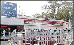
Railway Station Lalitpur Lal01.jpg
Railway Station Lalitpur

Lalitpur Junction has very good rail connections with major Indian cities including New Delhi, Mumbai, Chennai, Patna, Indore, Bhopal, Gwalior, Jabalpur, Ujjain, Saugor, Puri, Allahabad, Bengaluru, Damoh, Jhansi. [6] A new railway line connecting Lalitpur to Tikamgarh started in 2013.Now this line is extended up to Khajuraho. [7] The nearest junctions are Jhansi Junction and Bina Junction in Madhya Pradesh.

The important trains such as the shatabdi express Malwa Express, Punjab Mail, Bhopal - Lucknow Express, Jabalpur - Jammu Tawi Express, Gondwana Express, Bhopal Express, Shatabdi Express, sachkhand express, shatabdi express, mahamana express, pathankot express, Pushpak Express, Kushinagar Express and many other trains stop at Lalitpur.

Road

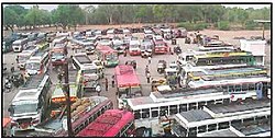
Bus Stand Lalitpur Lalitpur01.jpg
Bus Stand Lalitpur

The proposed North-south-Corridor of the Golden-Quadrilateral Highway project passes through lalitpur is completed.[ citation needed ]

Air

Lalitpur is the only place in Bundelkhand Region having an Airstrip maintained by the Airport Authority of India.[ citation needed ]

Related Research Articles

<span class="mw-page-title-main">Orchha</span> Town in Madhya Pradesh, India

Orchha is a town, near the city of Niwari in the Niwari district of Madhya Pradesh state, India. The town was established by a Bundela rajput ruler Rudra Pratap Singh some time after 1501, as the seat of an eponymous former princely state of covering parts of central & north India, in the Bundelkhand region. Orchha lies on the Betwa River, 80 km from Tikamgarh & 15 km from Jhansi in Uttar Pradesh.

<span class="mw-page-title-main">Chhatarpur</span> City in Madhya Pradesh, India

Chhatarpur is a city and a municipality in Chhatarpur district in the state of Madhya Pradesh, India. It is the administrative headquarters of Chhatarpur District.

<span class="mw-page-title-main">Datia</span> City in Madhya Pradesh, India

Datia is the district headquarter of the Datia District in north central Madhya Pradesh, a state of Central India. It is an ancient town, mentioned in the Mahabharata ruled by King Dantavakra. The city is 78 km from Gwalior, 325 km south of New Delhi and 344 km north of Bhopal. About 18 km from Datia is Sonagiri, a sacred Jain hill. Datia is also about 31 km from Jhansi and 52 km from Orchha. The nearest airport is at Gwalior. It was formerly the seat of the eponymous princely state in the British Raj. Datia is situated near Gwalior and on the border with Uttar Pradesh.

<span class="mw-page-title-main">Tikamgarh</span> City in Madhya Pradesh, India

Tikamgarh is a town and a tehsil in Tikamgarh district in the Indian state of Madhya Pradesh. The city serves as a district headquarters. The earlier name of Tikamgarh was Tehri consisting of three hamlets, forming a rough triangle. In Tikamgarh town there is locality still known as 'Purani Tehri'. Until Indian independence in 1947, Tikamgarh, formerly called Tehri, was part of the kingdom of Orchha, which was founded in the 16th century by the Bundeli chief Rudra Pratap Singh, who became the first King of Orchha. In 1783 the capital of the state was moved to Tehri, about 40 miles (64 km) south of Orchha, which was home to the fort of Tikamgarh, and the town eventually took the name of the fort. The district is famous for the old fort of Kundar known as Garh Kundar, which was built by Khangars and remained the capital of Khangar rulers from 1180 to 1347.

<span class="mw-page-title-main">Jainism in Bundelkhand</span>

Bundelkhand, a region in central India, has been an ancient center of Jainism. It covers northern part of Madhya Pradesh and south western part of Uttar Pradesh.

<span class="mw-page-title-main">Tikamgarh district</span> District of Madhya Pradesh in India

Tikamgarh district is one of the 52 districts of Madhya Pradesh state in central India. Tikamgarh town is the district headquarters. The district is part of Sagar Division.

<span class="mw-page-title-main">Lalitpur district, India</span> District in Uttar Pradesh, India

Lalitpur is one of the 75 districts in the northern Indian state of Uttar Pradesh. Lalitpur district is a part of Jhansi Division. Lalitpur is the main town and administrative headquarters. The district occupies an area of 5,039 km2.

Mauranipur is a town and a municipal board in Jhansi district state of Uttar Pradesh, India. It is located in the Jhansi District. It is the largest tehsils in India by land area. This town was known for textile production, known in ancient times as Madhupuri. Because of its high density of temples, it is known by some locals as Mini-Ayoddhya. Jalvihar Mela and Viman Yatra are the most famous events in Mauranipur. The Kedareshwar temple and the Saprar Dam are located near Mauranipur.

Badagaon Dhasan is a town and a Nagar Parishad in Tikamgarh district in the state of Madhya Pradesh, India.

Mandi Bamora is a census town in Sagar district in the state of Madhya Pradesh, India. This place has a railway station Mandi Bamora. Mandi Bamora located as half- half way in two different district Bina-etawa and Vidisha. Tehsil is Bina. Mandi Bamora is very famous as a name "Great country" because two different districts boundaries separated two places Bamora and Sihora.

Khargapur is a town and a nagar panchayat in Tikamgarh district in the Indian state of Madhya Pradesh. Khargapur is an assembly constituency.

Talbehat is a nagar panchayat city in Lalitpur district in the Indian state of Uttar Pradesh.

Pali is a town and a nagar panchayat in Lalitpur district in the Indian state of Uttar Pradesh.

<span class="mw-page-title-main">Parwar (Jain community)</span>

Parwar, also spelt as Paravāra, is a major Jain community from the Bundelkhand region, which is largely in Madhya Pradesh, but also includes the two districts of Lalitpur and Jhansi in Uttar Pradesh. Apart from them, Nagpur district (Maharashtra) have also a very large Parwar community. There is an area in Itwari of Nagpur known as Parwar-Pura having large number of Parwar's homes and shops. Most of the Nagpur's Parwar are migrated from Sagar, Deori, and other small villages of Sagar District of MP. Parwar exclusively follow the Digambar Jain tradition. Parwar usually preferred their marriage within community. There are 12 Gotra in Parwar community. Each Gotra has 12 Moor (lineages). A marriage within the same gotra or lineage are not allowed. Traditionally a marriage within any of the 8 branches was not permitted and hence the community was termed ashta-shakha.

<span class="mw-page-title-main">Dashavatara Temple, Deogarh</span> 6th century Hindu temple

The Dashavatara Temple is an early 6th century Hindu temple located at Deogarh, Uttar Pradesh which is 125 kilometers from Jhansi, in the Betwa River valley in northern-central India. It has a simple, one cell square plan and is one of the earliest Hindu stone temples still surviving today. Built in the Gupta Period, the Dashavatara Temple at Deogarh shows the ornate Gupta style architecture.

<span class="mw-page-title-main">Deogarh, Uttar Pradesh</span> Village in Uttar Pradesh, India

Deogarh is a village in Lalitpur district of the Indian state of Uttar Pradesh. It is located on the right bank of Betwa River and to the west of Lalitpur hills. It is known for Gupta monuments and for many ancient monuments of Jain origins inside and outside the walls of the fort.

<span class="mw-page-title-main">Orchha State</span> Princely state of India

Orchha State was a kingdom situated in the Bundelkhand region and later a princely state in British India. The state was ruled by Bundela clan of Rajputs. It was located within what is now the state of Madhya Pradesh.

<span class="mw-page-title-main">Jhansi Junction railway station</span> Railway Station in Uttar Pradesh, India

Jhansi Junction railway station is a major railway junction in the city of Jhansi in Bundelkhand region of Uttar Pradesh. It is one of the busiest and largest railway stations in India. It hosts various trains of Indian Railways like the Gatimaan Express, which is the fastest train of India, as well as others like Bundelkhand Express. It is a major halt for various important trains of Indian Railways like five sets of Rajdhani Express bound for Mumbai, Chennai, Bengaluru, Hyderabad etc. One set of Bhopal Shatabdi Express, three Duronto Express trains, Punjab Mail one of the oldest running trains in India, Kerala Express, Karnataka Express, etc.

Raj Rajeshwar Pratap Singh Judev also known as Raja Bundela is an Indian actor, producer, politician and civil activist.Presently He is the Vice President of Bundelkhand Vikas Board,Uttar Pradesh. In films, he is notable for appearances in Swarg, Shola Aur Shabnam, Pratha, Namestey LA, and Son of Flower. He was an actor/producer until the late 2000s, when he became a politician interested in civil rights and statehood for his native Bundelkhand in India.

<span class="mw-page-title-main">Lalitpur Junction railway station</span>

Lalitpur Junction railway station is an important railway station in Lalitpur district, Uttar Pradesh, India. Its code is LAR. It serves Lalitpur city and towns such as Chanderi in nearby Madhya Pradesh. The station consists of three platforms. The platforms are not well sheltered. The station was connected with Tikamgarh in 2013and further to Khajuraho by 2016.

References

  1. "Lalitpur City Census 2011 data". Census 2011 - Census of India.
  2. "Lalitpur City Census 2011 data". Census 2011 - Census of India.
  3. "Raja Mardan Singh". Indian Culture, Government of India.
  4. "Lalitpur City Census 2011 data". Census 2011 - Census of India.
  5. "Lalitpur City Census 2011 data". Census 2011 - Census of India.
  6. "List of trains passing through Lalitpur", Retrieved on 7 May 2015,
  7. "Tikamgarh of Madhya Pradesh connected with Rail Services", Jagran Josh , 27 April 2013. Retrieved on 7 May 2015

“Lalitpur founded by Raja Sumer Singh “https://zenodo.org/records/3978974