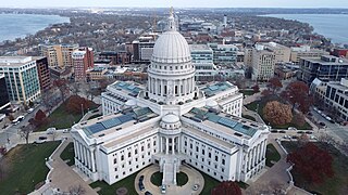
Madison is the county seat of Dane County and the capital city of the U.S. state of Wisconsin. As of the 2020 census the population was 269,840, making it the second-largest city in Wisconsin by population, after Milwaukee, and the 80th-largest in the U.S. Madison is named for American Founding Father and President James Madison.

Pasco County is located on the west central coast of the U.S. state of Florida. According to the 2020 census, the population was 561,691. Its county seat is Dade City, and its largest city is Zephyrhills. The county is named after Samuel Pasco.

Mequon is the largest city in Ozaukee County, in the U.S. state of Wisconsin, and the third-largest city in Wisconsin by land area. Located on Lake Michigan's western shore with significant commercial developments along Interstate 43, the community is a suburb in the Milwaukee metropolitan area. Despite being an incorporated city, approximately half of Mequon's land is undeveloped and agriculture plays a significant role in the local economy. At the time of the 2010 census the population was 23,132.

Land o' Lakes is a town in Vilas County, Wisconsin, United States. The population was 861 at the 2010 census. The unincorporated community of Land o' Lakes is located in the town.

Hartland is a village along the Bark River in Waukesha County, Wisconsin, United States, that is a suburb of Milwaukee. The population was 9,501 at the 2020 census.
Hartford is a city in Washington and Dodge counties in the U.S. state of Wisconsin. As of the 2010 census, the city had a population of 14,223. All of this population resided in the Washington County portion of the city. The portion of the city in Dodge County consists of only industrial/commercial parcels. Located approximately 38 miles (61 km) northwest of Downtown Milwaukee and 22 miles (35 km) from city limits, Hartford is located on the outer edge of the Milwaukee metropolitan area.
Fond du Lac is a city in, and the county seat of Fond du Lac County, Wisconsin, United States. The population was 44,678 at the 2020 census. The city forms the core of the United States Census Bureau's Fond du Lac Metropolitan Statistical Area, which includes all of Fond du Lac County. Fond du Lac is the 348th largest Metropolitan Statistical Area (MSA) in the United States.
Belgium is a town in Ozaukee County, Wisconsin, United States. The population was 1,513 at the 2000 census. The Village of Belgium is surrounded on all sides by the town, and the unincorporated communities of Decker, Holy Cross, Lake Church, and Sauk Trail Beach are located in the town, as is the ghost town of Stonehaven. The unincorporated community of Dacada is also partially located in the town.
Fredonia is a town in Ozaukee County, Wisconsin, United States. The population was 2,903 at the 2000 census. The Village of Fredonia is surrounded by the town. The unincorporated communities of Little Kohler and Waubeka are also located in the town.
The Town of Grafton is a town located in Ozaukee County, Wisconsin, United States, and is in the Milwaukee metropolitan area. The town was created in 1846 and at the time of the 2020 Census had a population of 4,157.

Port Washington is a town in Ozaukee County in the U.S. state of Wisconsin. It surrounds the northern and western side of the city of Port Washington. As of the 2000 census, the town population was 1,631. The unincorporated communities of Druecker and Knellsville are also located in the town.
Saukville is a town in Ozaukee County, Wisconsin, United States. The Village of Saukville is located in the town's southeast quadrant. The population was 1,755 at the 2000 census.

Burlington is a city in Racine and Walworth counties in the U.S. state of Wisconsin, with the majority of the city located in Racine County. The population of the city was 11,047 as of the 2020 census.
Hayward is a city in Sawyer County, Wisconsin, United States, next to the Namekagon River. Its population was 2,318 at the 2010 census. It is the county seat of Sawyer County. The city is surrounded by the Town of Hayward. The City of Hayward was formally organized in 1883.

Sheboygan is a city in and the county seat of Sheboygan County, Wisconsin, United States. The population was 49,929 at the 2020 census. It is the principal city of the Sheboygan, Wisconsin Metropolitan Statistical Area, which has a population of 118,034. The city is located on the western shore of Lake Michigan at the mouth of the Sheboygan River, about 50 miles north of Milwaukee and 64 mi (103 km) south of Green Bay.

Sheboygan Falls is a city in Sheboygan County, Wisconsin, United States. Its population was 8,210 at the 2020 census. The city's downtown is listed on the National Register of Historic Places and is the first Main Street Community in Wisconsin. The city is part of the Sheboygan, Wisconsin Metropolitan Statistical Area.

The Bad River LaPointe Band of the Lake Superior Tribe of Chippewa Indians or Bad River Tribe for short are a federally recognized tribe of Ojibwe people. The tribe had 6,945 members as of 2010. The Bad River Reservation is located on the south shore of Lake Superior and has a land area of about 193.11 square miles (500.15 km2) in northern Wisconsin, straddling Ashland and Iron counties. Odanah, the administrative and cultural center, is located five miles (8.0 km) east of the town of Ashland on U.S. Highway 2. The reservation population was 1,545 in 2020. Most of the reservation is managed as undeveloped forest and wetland, providing a habitat for wild rice and other natural resources.
Arrowhead High School is a high school located in Merton Town, Wisconsin. Sitting on 117 acres (0.47 km2) of land, the school has two campuses, a north campus and a south campus. Juniors and seniors attend the north campus, while freshmen and sophomores attend the south campus.

Glidden is an unincorporated census-designated place in the town of Jacobs in Ashland County, Wisconsin, United States. It is located on County Highway N near Wisconsin Highway 13. As of the 2010 census, its population was 507.


