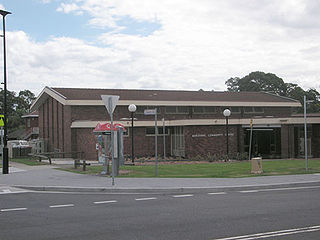
Marayong is a suburb of Sydney, in the state of New South Wales, Australia. Marayong is located 32 kilometres north west of the Sydney central business district, in the local government area of the City of Blacktown and is part of the Greater Western Sydney region.

Roadvale is a rural locality in the Scenic Rim Region, Queensland, Australia. In the 2016 census, Roadvale had a population of 286 people.

Culcairn is a town in the south-east Riverina region of New South Wales, Australia. Culcairn is located in the Greater Hume Shire local government area on the Olympic Highway between Albury and Wagga Wagga. The town is 514 kilometres (319 mi) south-west of the state capital, Sydney and at the 2006 census had a population of 1,120.

Spalding is a town located north of the Clare Valley in South Australia, Australia. At the 2006 census, Spalding had a population of 212.

City of Wagga Wagga is a local government area in the Riverina region of south-western New South Wales, Australia.

Kamarah, is a village community in the central north part of the Riverina. It is situated by road, about 11 kilometres west of Ardlethan and 12 kilometres east of Moombooldool. At the 2006 census, Kamarah had a population of 130 people.

Combaning is a rural community in the north east part of the Riverina. It is situated by road, about 3 kilometres west of Springdale and 13 kilometres east of Temora. At the 2006 census, Combaning had a population of 214 people.

Willbriggie is a community in the central part of the Riverina nearby to the city of Griffith. It is situated by road, about 16 kilometres north from Darlington Point and 17 kilometres south from Hanwood. At the 2006 census, Willbriggie had a population of 376.

Repton is a small town in New South Wales, Australia, located near the mouth of the Bellinger River. At the 2006 census, Repton had a population of 620 people.

Buxton is a rural locality in the Bundaberg Region, Queensland, Australia. In the 2016 census, Buxton had a population of 430 people.

Farrell Flat is a town in South Australia. The town is located 20 kilometres (12 mi) east of Clare and 22 kilometres (14 mi) southwest of Burra on the former Peterborough railway line, in the Regional Council of Goyder. At the 2006 census, Farrell Flat and the surrounding area had a population of 294.
Gurranang is a locality between the towns of Casino and Grafton on the Summerland Way in northern New South Wales, Australia. The North Coast railway passes through, and a railway station was provided between 1905 and 1972. At the 2006 census, Gurranang had a population of 170 people.
Kungala is a locality south of Grafton in northern New South Wales, Australia. The North Coast railway passes through, and a railway station and sidings were provided from 1915 to 1974. At the 2006 census, Kungala had a population of 205 people. The town's name is derived from an aboriginal term meaning "to shout and listen".
Ardglen is a village on the Main North railway line and close to the New England Highway on the North West Slopes region of New South Wales, Australia.
Parkville is a small township in the Hunter Region of New South Wales, Australia, located on the New England Highway and Main North railway line. At the 2006 census, Parkville had a population of 721 people.
Kundabung is a locality on the North Coast of New South Wales, Australia.

Warialda Rail is a town in the New England region of New South Wales, Australia. The town is located 3 km southwest of Warialda in the Gwydir Shire local government area, 581 kilometres (361 mi) north of the state capital, Sydney. At the 2006 census, Warialda Rail and the surrounding area had a population of 345.

Stockwell is a settlement in South Australia. At the 2006 census, Stockwell had a population of 534. Stockwell is named after Samuel Stockwell, an early landowner in the area. Stockwell was a station on the Truro railway line from 1917 to 1968 when the line closed to regular service.

Coonana is a small Indigenous Australian community in Western Australia located 775 kilometres (482 mi) east of Perth between Kalgoorlie and Laverton in the Goldfields-Esperance region of Western Australia. At the 2006 census, Coonana had a population of 83.
