
Grafton is a city in the Northern Rivers region of the Australian state of New South Wales. It is located on the Clarence River, approximately 608 kilometres (378 mi) by road north-northeast of the state capital Sydney. The closest major cities, Brisbane and the Gold Coast, are located across the border in South-East Queensland. At June 2018 Grafton had a population of 19,078. The city is the largest settlement and administrative centre of the Clarence Valley Council local government area, which is home to over 50,000 people in all.

Clarence Valley Council is a local government area in the Northern Rivers region of New South Wales, Australia.

Nambucca Valley Council is a local government area in the mid north coast region of New South Wales, Australia.

Hornsby Shire is a local government area situated in Northern Sydney, as well as parts of the Hills District, in the state of New South Wales, Australia. The shire stretches from the M2 Hills Motorway in the south to the Hawkesbury River town of Wisemans Ferry, some 53 kilometres (33 mi) to the north, making it the largest local government council in the Greater Sydney Metropolitan region by total area. As of the 2016 census the shire had an estimated population of 142,667.

The City of Hawkesbury is a local government area of New South Wales, Australia, part of which is at the fringe of the Sydney metropolitan area, about 50 kilometres (31 mi) north-west of the Sydney central business district. Hawkesbury City is named after the Hawkesbury River.

Coutts Crossing is a rural village located in the Clarence Valley region and Clarence Valley Council of New South Wales, Australia. The village is about 18 kilometres south-west of Grafton on the banks of the Orara River along the Armidale–Grafton Road. The village is named after Thomas Coutts, a settler who established the nearby Kangaroo Creek pastoral station in 1840. Coutts is best known as being the perpetrator of a mass poisoning of Aboriginals on the Kangaroo Creek run. This occurred in late 1847 and resulted in the deaths of 23 people. Coutts was arrested and sent to Sydney for trial but the case was dismissed. He returned to the area and was able to continue acquiring pastoral properties further north.
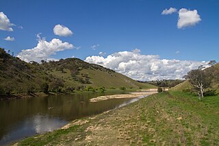
The Clarence River is a river situated in the Northern Rivers district of New South Wales, Australia.

Nambucca Heads is a town on the Mid North Coast of New South Wales, Australia in the Nambucca Valley. It is located on a ridge, north of the estuary of the Nambucca River near the Pacific Highway. Its 2011 population was 6,137, including 602 (9.7%) indigenous persons and 5,180 (83.3%) Australian-born persons in the Shire. The place name is derived from an Gumbaynggirr word Ngambagabaga. Clement Hodgkinson asked two Ngamba men what the name of the area was they responded to Nyambagabaga as the spot they were standing was a bend in the river where a Ngamba giant was speared in the leg in the Dreaming. This location is the Foreshore Caravan Park now. Ngamba is a subsection of Gumbaynggirr Nation & Baga Baga means Knee. This was later interpreted as Nambucca. It is a popular holiday and retirement destination.

Woodburn is a small highway town on the banks of the Richmond River in New South Wales, Australia. Until the town was bypassed in September 2020, the busy Pacific Highway passed through the centre of town. Woodburn is 712 km north of the state capital, Sydney, and 34 km south of the regional city of Lismore.

Maclean is a town in Clarence Valley local government area in the Northern Rivers region of New South Wales, Australia. It is on the Clarence River and near the Pacific Highway. At the 2016 census, Maclean had a population of 2,628. The Maclean, Yamba and Iluka area had a population of 16,279. Its industries are tourism, sugar cane production, farming and river-prawn trawling.

Clarence Town is both a primarily rural locality and a township in the Dungog Shire local government area in the Hunter Region of New South Wales, Australia. It is 193 kilometres (120 mi) north of Sydney, 54 km (34 mi) north-north-west of Newcastle, and 28 km (17 mi) from the Pacific Highway at Raymond Terrace. The locality is bisected by the Williams River. The township sits just to the west of the river about 32 km (20 mi) upstream from where it flows into the Hunter River at Raymond Terrace.

Brewarrina Shire is a local government area in the Orana region of New South Wales, Australia. The Shire is located adjacent to the Darling River, which is known as the Barwon River upstream from Bourke; and located adjacent to the Kamilaroi Highway. The northern boundary of the Shire is located adjacent to the border between New South Wales and Queensland. The Shire is a wool and cotton growing area.
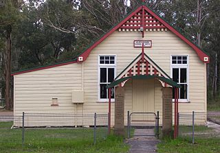
Lawrence is a small town 13 km from Maclean, New South Wales, Australia. It is accessed by the Lawrence car ferry from Woodford Island or by travelling 30 kilometres north from Grafton. At the 2006 census, Lawrence had a population of 390 people. Lawrence has a number of sporting facilities including, a cricket field and soccer fields, a nine-hole golf course and tennis courts. Lawrence has a public school, a general store, post office, police station, Tavern and a local school and route bus service. It also has a museum housed in the old radio station building as well as very well preserved Public Hall of timber construction dating from 1892. The town is in the Clarence Valley Council local government area.
Cavan is a rural community situated on the south bank of the Murrumbidgee River in the Yass Valley Shire. At the 2016 census, it had a population of 47. It is situated by road, about 40 kilometres southwest of Yass and 43 northwest of Canberra. It was named after the town of Cavan in Ireland.
Glen Oak is a small community in the Hunter Region of New South Wales, Australia, shared between the Port Stephens and Dungog local government areas (LGA). Approximately two thirds of the suburb's 45.1 square kilometres (17.4 sq mi) is located within the Port Stephens LGA while the remaining third, which is sparsely populated, is located in Dungog Shire.
Upper Kangaroo River is a small village in the Southern Highlands of New South Wales, Australia, in Shoalhaven City Council. It is located on the Kangaroo River, a tributary of the Shoalhaven River. At the 2016 census, it had a population of 122.

Gunderman is a locality of the Central Coast region of New South Wales, Australia, located on the north bank of the Hawkesbury River between the towns of Wisemans Ferry and Spencer. It is located within the Central Coast Council local government area. It adjoins the Dharug National Park. At the 2006 census, Gunderman had a population of 137 people.
The Lawrence Ferry is a cable ferry across the Clarence River in New South Wales, Australia. The ferry operates between the town of Lawrence and Woodford Island, and forms part of the route east from Lawrence to the coast. It is the busiest vehicular ferry in New South Wales.
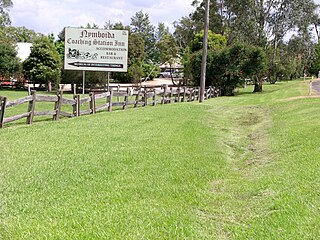
Nymboida is a rural village in the Northern Rivers region of New South Wales, Australia. It is about 21 kilometres south-west of Coutts Crossing, 44 kilometres south-west of Grafton and approximately 687 km north of Sydney. Nymboida is close to the challenging and popular white water rafting waters of the Nymboida River along the Armidale–Grafton Road. The village is in the Clarence Valley Council local government area.


 Map of the town of Grafton New South wales in 1886, by John Sands
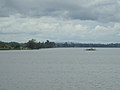 The Clarence River, with the Ulmarra Ferry
