Laua-an

Last updated
Laua-an
Municipality of Laua-an
Flag of Laua-an, Antique.png
Ph locator antique laua-an.png
Map of Antique with Laua-an highlighted
OpenStreetMap
Laua-an
Philippines location map (square).svg
Red pog.svg
Laua-an
Location within the Philippines
Coordinates: 11°08′35″N122°02′30″E / 11.142944°N 122.041733°E / 11.142944; 122.041733
Country Philippines
Region Western Visayas
Province Antique
District Lone district
Founded January 1, 1915
Barangays 40 (see Barangays)
Government
[1]
  Type Sangguniang Bayan
   Mayor Francisco G. Baladjay Jr.
   Vice Mayor Joean B. Samillano
   Representative Loren Legarda
   Municipal Council
Members
   Electorate 19,526 voters (2022)
Area
[2]
  Total100.72 km2 (38.89 sq mi)
Elevation
228 m (748 ft)
Highest elevation
(Mount Dumara)
1,287 m (4,222 ft)
Lowest elevation
0 m (0 ft)
Population
 (2020 census) [3]
  Total26,580
  Density260/km2 (680/sq mi)
   Households
6,674
Economy
   Income class 4th municipal income class
   Poverty incidence
21.91
% (2018) [4]
   Revenue 112.2 million (2020)
   Assets 253.6 million (2020)
   Expenditure 83.88 million (2020)
   Liabilities 47.27 million (2020)
Service provider
  ElectricityAntique Electric Cooperative (ANTECO)
Time zone UTC+8 (PST)
ZIP code
5705
PSGC
IDD : area code +63(0)36
Native languages Karay-a
Hiligaynon
Tagalog

Laua-an, officially the Municipality of Laua-an (Kinaray-a : Banwa kang Laua-an; Hiligaynon : Banwa sang Laua-an; Tagalog : Bayan ng Laua-an), is a 4th class municipality in the province of Antique, Philippines. According to the 2020 census, it has a population of 26,580 people. [3] Making it 12th most populous municipality in the province of Antique. Laua-an celebrates its Pahinis Festival every January.

Contents

Geography

Laua-an is 56 kilometres (35 mi) from the provincial capital, San Jose de Buenavista.

According to the Philippine Statistics Authority, the municipality has a land area of 100.72 square kilometres (38.89 sq mi) [5] constituting

Climate

Climate data for Laua-an, Antique
MonthJanFebMarAprMayJunJulAugSepOctNovDecYear
Average high °C (°F)30
(86)
31
(88)
32
(90)
33
(91)
32
(90)
30
(86)
29
(84)
29
(84)
29
(84)
29
(84)
30
(86)
30
(86)
30
(87)
Average low °C (°F)22
(72)
22
(72)
22
(72)
24
(75)
25
(77)
25
(77)
25
(77)
25
(77)
25
(77)
24
(75)
23
(73)
22
(72)
24
(75)
Average precipitation mm (inches)48
(1.9)
41
(1.6)
58
(2.3)
82
(3.2)
223
(8.8)
300
(11.8)
346
(13.6)
307
(12.1)
311
(12.2)
292
(11.5)
167
(6.6)
81
(3.2)
2,256
(88.8)
Average rainy days11.47.711.315.425.728.529.528.728.328.721.815.2252.2
Source: Meteoblue (modeled/calculated data, not measured locally) [6]

Barangays

Laua-an is politically subdivided into 40 barangays. [7] Each barangay consists of puroks and some have sitios.

There are 12 barangays which located along the coast and the rest are considered inland/upland barangays located along two big rivers of Paningayan and Cairawan. It has a total of 85 sitios, The total land area of Laua-an is approximately 18,692,456.5 hectares, representing 7.41% of the total land area of the Province of Antique. Of the total land area 7,832,222.9 has. Or 42% is alienable and disposable land and 10,860,2336 has. Or 58% is classified as timber land. Total Population of Laua-an in 2009 as per survey conducted by the Municipal Social Work and Development Office (MSWDO), reached to 26,959 in which 13,468 are males and 13,491 are females with total households of 5,392.

PSGC Barangay Population ±% p.a.
2020 [3] 2010 [8]
060609043 Bagongbayan 2.7% 706 659 0.69%
060609002 Banban 0.6% 147 129 1.31%
060609003 Bongbongan 0.9% 250 265 −0.58%
060609004 Cabariwan 2.5% 660 620 0.63%
060609005 Cadajug 4.3% 1,153 1,110 0.38%
060609006 Canituan 2.1% 568 572 −0.07%
060609007 Capnayan 1.4% 365 319 1.36%
060609008 Casit-an 4.5% 1,200 1,157 0.37%
060609010 Guiamon 0.9% 249 239 0.41%
060609009 Guinbanga-an 7.1% 1,879 1,864 0.08%
060609011 Guisijan 9.0% 2,404 2,382 0.09%
060609012 Igtadiao 1.1% 294 262 1.16%
060609013 Intao 2.5% 660 672 −0.18%
060609014 Jaguikican 3.3% 874 896 −0.25%
060609015 Jinalinan 0.8% 202 220 −0.85%
060609016 Lactudan 0.9% 247 274 −1.03%
060609017 Latazon 1.8% 476 494 −0.37%
060609018 Laua-an 1.4% 379 349 0.83%
060609020 Liberato 1.5% 411 463 −1.18%
060609021 Lindero 6.2% 1,649 1,560 0.56%
060609022 Liya-liya 1.6% 422 395 0.66%
060609019 Loon 2.8% 743 735 0.11%
060609023 Lugta 2.7% 719 576 2.24%
060609024 Lupa-an 2.1% 559 557 0.04%
060609025 Magyapo 1.0% 257 242 0.60%
060609026 Maria 4.9% 1,311 1,364 −0.40%
060609027 Mauno 2.0% 524 457 1.38%
060609028 Maybunga 2.0% 525 343 4.35%
060609029 Necesito (Paniatan) 1.2% 307 339 −0.99%
060609030 Oloc 4.4% 1,168 994 1.63%
060609031 Omlot 1.0% 260 233 1.10%
060609032 Pandanan 1.4% 359 346 0.37%
060609034 Paningayan 1.4% 384 360 0.65%
060609035 Pascuala 0.7% 194 202 −0.40%
060609036 Poblacion (Centro) 7.4% 1,975 1,933 0.22%
060609038 San Ramon 0.6% 167 139 1.85%
060609039 Santiago 2.5% 670 622 0.75%
060609040 Tibacan 0.7% 177 230 −2.58%
060609041 Tigunhao 1.3% 343 375 −0.89%
060609042 Virginia 0.9% 235 263 −1.12%
Total26,58025,2110.53%


Demographics

Population census of Laua-an
YearPop.±% p.a.
1903 8,915    
1918 10,340+0.99%
1939 12,614+0.95%
1948 15,438+2.27%
1960 12,967−1.44%
1970 15,461+1.77%
1975 17,498+2.51%
1980 18,785+1.43%
1990 19,865+0.56%
1995 21,069+1.11%
2000 23,258+2.14%
2007 23,808+0.32%
2010 25,211+2.11%
2015 26,072+0.64%
2020 26,580+0.38%
Source: Philippine Statistics Authority [9] [8] [10] [11]

In the 2020 census, Laua-an had a population of 26,580. [3] The population density was 260 inhabitants per square kilometre (670/sq mi).

Economy

Muscovado brown sugarcane sugar Brown sugar examples.JPG
Muscovado brown sugarcane sugar
Cut sugarcane Cut sugarcane.jpg
Cut sugarcane

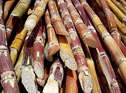
Laua-an has an agricultural-based economy with rice, sugarcane and corn as primary crops. About 4,267,264 has. are devoted to agricultural crop production representing 22.83% of the total land area of the municipality. Laua-an produce Rice, Corn, Vegetables, Peanuts, Mango, Banana, Abaca and other crops. It has 42 Day Care Centers, 12 Complete Elementary Schools and 4 Secondary Schools. In Health services, it has 1 Rural Health Center, 8 Barangay Health Stations and 13 Health & Nutrition Posts. Laua-an has a total of 76.065 km. of Barangay roads; 2.160 km. of municipal roads; 2.450 km. of provincial roads and 11.125 km. of National Roads. A mini-hydro project is being constructed at Brguy. San Ramon by Sun West Water and Electric Company and at Sitio Sadsadan, Barangay Maybunga and Villa Siga Bugasong. Four cell sites (Globe, Sun and Smart) were installed at Barangay Poblacion, Bagongbayan and Liya-Liya rerspectively. It is observed that even upland barangays have signal which contributed to the improvement of information technology in the area.

Farming is the major occupation of the people and fishing is the secondary source of income. The deep sea waters of Sulu Sea is abundant with fish and marine life like sardines, tuna, squids, mackerel, crabs and other seafoods which is a source of living for most residents.

Tourism

Among the tourist attractions are Mount Igmatongtong in barangay Capnayan, Maybunga Water falls in barangay Maybunga, and Estaka Hill in barangay Poblacion. Estaca Hill in the Poblacion provides a strategic place to view the barangay Poblacion, the Sulu Sea and its environs.

Festivals

Pre-Catholic pre-Spanish Indianized Srivijaya-era Pahinis Festival similar to Makar Sankranti, is celebrated annually to feature the muscovado sugar industry of the town, the technology of which dates back to the Spanish era. "Pahinis" means to clean and prepare the tools for sugarcane milling which corresponds to a celebration to thank God for a fine harvest of sugarcane.

The town celebrates its centennial foundation in January 2015. Weeklong celebration features Pahinis Festival Mardi Gras; LGU, professionals, senior citizens and barangay night; Bugal Kang Laua-an (Pride of Laua-an) Awards Night; and Search for Hara de Pahinis (Pahinis Queen) Beauty Pageant and Coronation Night. The winner of this pageant represents the municipality during the Search for Lin-ay kang Antique (Miss Antique) during the Binirayan Festival in the capital town of San Jose de Buenavista every last week of December. Other events include boat racing along the Sulu Sea, and Aring Beach Festival at the last night of the celebration in Barangay Cadajug.

Related Research Articles

<span class="mw-page-title-main">Malinao, Aklan</span> Municipality in Aklan, Philippines

Malinao, officially the Municipality of Malinao, is a 4th class municipality in the province of Aklan, Philippines. According to the 2020 census, it has a population of 24,517 people.

<span class="mw-page-title-main">Balangiga</span> Municipality in Eastern Samar, Philippines

Balangiga, officially the Municipality of Balangiga, is a 4th class municipality in the province of Eastern Samar, Philippines. According to the 2020 census, it has a population of 14,341 people.

<span class="mw-page-title-main">Buenavista, Guimaras</span> Municipality in Guimaras, Philippines

Buenavista, officially the Municipality of Buenavista, is a 2nd class municipality and the largest settlement in the province of Guimaras, Philippines. According to the 2020 census, it has a population of 52,899 people.

<span class="mw-page-title-main">Balete, Aklan</span> Municipality in Aklan, Philippines

Balete, officially the Municipality of Balete, is a 4th class municipality in the province of Aklan, Philippines. According to the 2020 census, it has a population of 30,090 people.

<span class="mw-page-title-main">Buruanga</span> Municipality in Aklan, Philippines

Buruanga, officially the Municipality of Buruanga, is a 5th class municipality in the province of Aklan, Philippines. It is the farthest town of Aklan from its provincial capital. According to the 2020 census, it has a population of 19,357 people.

<span class="mw-page-title-main">Madalag</span> Municipality in Aklan, Philippines

Madalag, officially the Municipality of Madalag, is a 4th class municipality in the province of Aklan, Philippines. It is Aklan's largest municipality by land area and also the most sparsely populated. According to the 2020 census, it has a population of 18,890 people.

<span class="mw-page-title-main">Himamaylan</span> Component city in Negros Occidental, Philippines

Himamaylan, officially the City of Himamaylan, is a 3rd class component city in the province of Negros Occidental, Philippines. According to the 2020 census, it has a population of 116,240 people.

<span class="mw-page-title-main">La Castellana, Negros Occidental</span> Municipality in Negros Occidental, Philippines

La Castellana, officially the Municipality of La Castellana, is a 1st class municipality in the province of Negros Occidental, Philippines. According to the 2020 census, it has a population of 79,492 people.

<span class="mw-page-title-main">Moises Padilla</span> Municipality in Negros Occidental, Philippines

Moises Padilla, officially the Municipality of Moises Padilla, is a 3rd class municipality in the province of Negros Occidental, Philippines. According to the 2020 census, it has a population of 43,462 people.

<span class="mw-page-title-main">Barbaza</span> Municipality in Antique, Philippines

Barbaza, officially the Municipality of Barbaza, is a 4th class municipality in the province of Antique, Philippines. According to the 2020 census, it has a population of 23,359 people.

<span class="mw-page-title-main">Hamtic</span> Municipality in Antique, Philippines

Hamtic, officially the Municipality of Hamtic,, is a 3rd class municipality in the province of Antique, Philippines. According to the 2020 census, it has a population of 52,685 people. Making it third most populous municipality in the province of Antique.

<span class="mw-page-title-main">Libertad, Antique</span> Municipality in Antique, Philippines

Libertad, officially the Municipality of Libertad,, is a 5th class municipality in the province of Antique, Philippines. According to the 2020 census, it has a population of 17,507 people, making it the 17th most populous municipality in the province of Antique.

<span class="mw-page-title-main">Valderrama, Antique</span> Municipality in Antique, Philippines

Valderrama, officially the Municipality of Valderrama, is a 4th class municipality in the province of Antique, Philippines. According to the 2020 census, it has a population of 19,971 people. Making it 15th most populous municipality in the province of Antique and the second largest municipality in terms of land area, with a total area of 273.79 square kilometers.

<span class="mw-page-title-main">Jamindan</span> Municipality in Capiz, Philippines

Jamindan, officially the Municipality of Jamindan, is a 2nd class municipality in the province of Capiz, Philippines. According to the 2020 census, it has a population of 38,670 people.

<span class="mw-page-title-main">Mambusao</span> Municipality in Capiz, Philippines

Mambusao, officially the Municipality of Mambusao, is a 3rd class municipality in the province of Capiz, Philippines. According to the 2020 census, it has a population of 40,690 people.

<span class="mw-page-title-main">Panitan</span> Municipality in Capiz, Philippines

Panitan, officially the Municipality of Panitan, is a 3rd class municipality in the province of Capiz, Philippines. According to the 2020 census, it has a population of 42,565 people.

<span class="mw-page-title-main">Lambunao</span> Municipality in Iloilo, Philippines

Lambunao, officially the Municipality of Lambunao, is a 1st class municipality in the province of Iloilo, Philippines. According to the 2020 census, it has a population of 81,236 people.

<span class="mw-page-title-main">San Enrique, Iloilo</span> Municipality in Iloilo, Philippines

San Enrique, officially the Municipality of San Enrique, is a 3rd class municipality in the province of Iloilo, Philippines. According to the 2020 census, it has a population of 36,911 people.

<span class="mw-page-title-main">San Miguel, Iloilo</span> Municipality in Iloilo, Philippines

San Miguel, officially the Municipality of San Miguel, is a 4th class municipality in the province of Iloilo, Philippines. According to the 2020 census, it has a population of 30,115 people.

<span class="mw-page-title-main">Zarraga</span> Municipality in Iloilo, Philippines

Zarraga, officially the Municipality of Zarraga, is a 4th class municipality in the province of Iloilo, Philippines. According to the 2020 census, it has a population of 27,305 people.

References

  1. Municipality of Laua-an | (DILG)
  2. "2015 Census of Population, Report No. 3 – Population, Land Area, and Population Density" (PDF). Philippine Statistics Authority. Quezon City, Philippines. August 2016. ISSN   0117-1453. Archived (PDF) from the original on May 25, 2021. Retrieved July 16, 2021.
  3. 1 2 3 4 Census of Population (2020). "Region VI (Western Visayas)". Total Population by Province, City, Municipality and Barangay. Philippine Statistics Authority . Retrieved 8 July 2021.
  4. "PSA Releases the 2018 Municipal and City Level Poverty Estimates". Philippine Statistics Authority. 15 December 2021. Retrieved 22 January 2022.
  5. "Province: Antique". PSGC Interactive. Quezon City, Philippines: Philippine Statistics Authority . Retrieved 12 November 2016.
  6. "Laua-an: Average Temperatures and Rainfall". Meteoblue. Retrieved 1 May 2020.
  7. "Municipal: Laua-an". PSGC Interactive. Quezon City, Philippines: Philippine Statistics Authority . Retrieved 8 January 2016.
  8. 1 2 Census of Population and Housing (2010). "Region VI (Western Visayas)". Total Population by Province, City, Municipality and Barangay. National Statistics Office . Retrieved 29 June 2016.
  9. Census of Population (2015). "Region VI (Western Visayas)". Total Population by Province, City, Municipality and Barangay. Philippine Statistics Authority . Retrieved 20 June 2016.
  10. Censuses of Population (1903–2007). "Region VI (Western Visayas)". Table 1. Population Enumerated in Various Censuses by Province/Highly Urbanized City: 1903 to 2007. National Statistics Office.
  11. "Province of Antique". Municipality Population Data. Local Water Utilities Administration Research Division. Retrieved 17 December 2016.
  12. "Poverty incidence (PI):". Philippine Statistics Authority. Retrieved December 28, 2020.
  13. "Estimation of Local Poverty in the Philippines" (PDF). Philippine Statistics Authority. 29 November 2005.
  14. "2003 City and Municipal Level Poverty Estimates" (PDF). Philippine Statistics Authority. 23 March 2009.
  15. "City and Municipal Level Poverty Estimates; 2006 and 2009" (PDF). Philippine Statistics Authority. 3 August 2012.
  16. "2012 Municipal and City Level Poverty Estimates" (PDF). Philippine Statistics Authority. 31 May 2016.
  17. "Municipal and City Level Small Area Poverty Estimates; 2009, 2012 and 2015". Philippine Statistics Authority. 10 July 2019.
  18. "PSA Releases the 2018 Municipal and City Level Poverty Estimates". Philippine Statistics Authority. 15 December 2021. Retrieved 22 January 2022.