Friesland, historically and traditionally known as Frisia, named after the Frisians, is a province of the Netherlands located in the country's northern part. It is situated west of Groningen, northwest of Drenthe and Overijssel, north of Flevoland, northeast of North Holland, and south of the Wadden Sea. As of January 2023, the province had a population of about 660,000, and a total area of 5,753 km2 (2,221 sq mi).
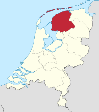
Groningen is the northeasternmost province of the Netherlands. It borders on Friesland to the west, Drenthe to the south, the German state of Lower Saxony to the east, and the Wadden Sea to the north. As of January 2023, Groningen had a population of about 596,000, and a total area of 2,955 km2 (1,141 sq mi).
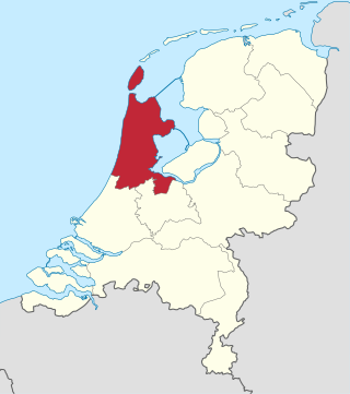
North Holland is a province of the Netherlands in the northwestern part of the country. It is located on the North Sea, north of South Holland and Utrecht, and west of Friesland and Flevoland. As of January 2023, it had a population of about 2,952,000 and a total area of 4,092 km2 (1,580 sq mi), of which 1,429 km2 (552 sq mi) is water.
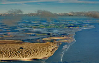
The Wadden Sea is an intertidal zone in the southeastern part of the North Sea. It lies between the coast of northwestern continental Europe and the range of low-lying Frisian Islands, forming a shallow body of water with tidal flats and wetlands. It has a high biological diversity and is an important area for both breeding and migrating birds. In 2009, the Dutch and German parts of the Wadden Sea were inscribed on UNESCO's World Heritage List and the Danish part was added in June 2014.

Frisia is a cross-border cultural region in Northwestern Europe. Stretching along the Wadden Sea, it encompasses the north of the Netherlands and parts of northwestern Germany. Wider definitions of "Frisia" may include the island of Rem and the other Danish Wadden Sea Islands. The region is traditionally inhabited by the Frisians, a West Germanic ethnic group.

De Marne is a former municipality in the northeast of the Netherlands. On 1 January 2019 it merged with the municipalities of Bedum, Eemsmond and Winsum to form the new municipality Het Hogeland.

Harlingen is a municipality and a city in the northern Netherlands, in the province of Friesland.

Rottumeroog is an uninhabited island in the Wadden Sea and is part of the Netherlands. The island is one of three West Frisian Islands in the province of Groningen. It is situated between the islands of Rottumerplaat and Borkum.

Zuiderduintjes is an uninhabited island in the Wadden Sea in the Netherlands. It is situated south of Rottumeroog, east of Rottumerplaat, and west of Borkum. The island is one of the three West Frisian Islands in the municipality of Het Hogeland and in the province of Groningen.
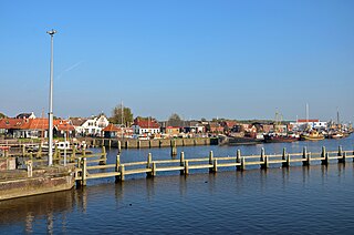
Zoutkamp is a village in the municipality Het Hogeland which is part of the province Groningen in the Netherlands. The village started as a sconce. During the Dutch Revolt, it was the site of the Battle of Zoutkamp. Later it became a fishing village. The harbour was moved to Lauwersoog in 1969 as a result of the closure of the Lauwersmeer, and is nowadays used for recreational purposes. The economy of the village mainly depends on fishing.

The Lauwers is a river in the Netherlands. It forms part of the border between the provinces of Friesland and Groningen. From the 730s to Widukind's defeat in 785, it was part of the border of the Frankish Empire.

The Dollart or Dollard is a bay in the Wadden Sea between the northern Netherlands and Germany, on the west side of the estuary of the Ems river. Most of it dries at low tide. Many water birds feed there.

Lauwersmeer is a man-made lake in the north of the Netherlands, on the border of the provinces of Groningen and Friesland. The lake was formed on 23 May 1969, when the dike between the bay called Lauwers Sea and the Wadden Sea was closed. It is noted for birdwatching.

Oosterbierum is a village in Waadhoeke municipality in the province of Friesland, the Netherlands. It had a population of around 561 in January 2014.

The Lower Saxon Wadden Sea National Park was established in 1986 and embraces the East Frisian Islands, mudflats and salt marshes between the Bay of Dollart on the border with the Netherlands in the west and Cuxhaven as far as the Outer Elbe shipping channel in the east. The national park has an area of about 345,800 hectares (1,335 sq mi). The National Park organisation is located in Wilhelmshaven. In June 2009, the National Park became a UNESCO World Heritage Site along with the Schleswig-Holstein Wadden Sea and the Dutch Wadden Sea, highlighting its unique intertidal ecosystem and high biodiversity.

Theunis Piersma is a Dutch ornithologist, ecologist, and educator. He is among the most influential ornithologists, particularly in the wader bird area, in the world. He specifically looks at waders and correlations between flock size and distribution, climate, food, predators, pathogens, and their historical-genetic background. RTV Drenthe referred to him in 2012 as the "first migratory bird professor in the world."
Mediahuis Noord, formerly known as NDC Mediagroep, is a Dutch publisher of newspapers, magazines, and websites focused on the three northern provinces of the Netherlands: Drenthe, Friesland and Groningen. It is owned by Mediahuis, a Belgian company. Headquarters are in Leeuwarden, other offices are in Groningen and Meppel. In addition to three main provinces, NDC publishes and distributes also in the Kop van Overijssel, Noordoostpolder, and northern Flevoland.

Lauwersoog is a seaside village and harbour in the province of Groningen, located in the northern part of the Netherlands. It is part of the municipality of Het Hogeland. It was established on 23 May 1969. The ferry to Schiermonnikoog departs from Lauwersoog.

Visvliet is a village in the Dutch province of Groningen. It is part of the municipality of Westerkwartier, and is located near the river Lauwers, the border between Friesland and Groningen.

Lauwerzijl is a village in the municipality of Westerkwartier in the province of Groningen in the Netherlands. As of 2021, it had a population of 195. Until 1990 the village belonged to the former municipality of Oldehove, then until 2019 to the former municipality of Zuidhorn.

