Lawyers Bar, California

Last updated

Coordinates: 41°52′10″N123°49′53″W / 41.86944°N 123.83139°W / 41.86944; -123.83139

Geographic coordinate system Coordinate system

A geographic coordinate system is a coordinate system that enables every location on Earth to be specified by a set of numbers, letters or symbols. The coordinates are often chosen such that one of the numbers represents a vertical position and two or three of the numbers represent a horizontal position; alternatively, a geographic position may be expressed in a combined three-dimensional Cartesian vector. A common choice of coordinates is latitude, longitude and elevation. To specify a location on a plane requires a map projection.

Lawyers Bar
Former settlement
USA California location map.svg
Red pog.svg
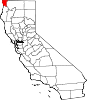
Lawyers Bar
Location in California
Coordinates: 41°52′10″N123°49′53″W / 41.86944°N 123.83139°W / 41.86944; -123.83139
Country United States
State California
County Del Norte County
Elevation [1] 899 ft (274 m)

Lawyers Bar (also, Sawyers Bar) [2] was a settlement in Klamath County now Del Norte County, California, United States. It was located on the Middle Fork of the Smith River, [2] at an elevation of 899 feet (274 m). It still appeared on maps as of 1922.

Klamath County, California County in the United States

Klamath County was a county of California from 1851 to 1874. During its existence, the county seat moved twice and ultimately portions of the territory it once had were carved up and added to nearby counties. It was formed from the northwestern portion of Trinity County, and originally included all of the northwestern part of the state, from the Mad River in the south to Oregon in the north, from the Pacific Ocean in the west to the middle of what is now Siskiyou County in the east. It is the only county in California to be disestablished.

Del Norte County, California County in California ----

Del Norte County is a county at the far northwest corner of the U.S. state of California, along the Pacific Ocean adjacent to the Oregon border. As of the 2010 census, the population was 28,610. The county seat and only incorporated city is Crescent City. Del Norte was pioneered and settled by Azorean Portuguese explorers and dairy farmers, which may account for the local pronunciation of the county name. Residents pronounce the county name as Del Nort, not Del Nor-teh as would be expected in Spanish.

California State of the United States of America

California is a state in the Pacific Region of the United States. With 39.6 million residents, California is the most populous U.S. state and the third-largest by area. The state capital is Sacramento. The Greater Los Angeles Area and the San Francisco Bay Area are the nation's second and fifth most populous urban regions, with 18.7 million and 9.7 million residents respectively. Los Angeles is California's most populous city, and the country's second most populous, after New York City. California also has the nation's most populous county, Los Angeles County, and its largest county by area, San Bernardino County. The City and County of San Francisco is both the country's second-most densely populated major city after New York City and the fifth-most densely populated county, behind only four of the five New York City boroughs.

Related Research Articles

Orleans, California Unincorporated community in California, United States

Orleans, is an unincorporated community in Humboldt County, California. It is located 12 miles (19 km) northeast of Weitchpec along State Route 96, at an elevation of 404 feet. The ZIP Code is 95556. It is within the area code 530. It is within the aboriginal territory of the Karuk Tribe of California.

Nelson Bar, California Former settlement in California, United States

Nelson Bar is a former settlement in Butte County, California. It was located 5.25 miles (8.45 km) southeast of Paradise on the West Branch of the Feather River, at an elevation of 974 feet. It is now under Lake Oroville.

Adams Station, California Unincorporated community in California, United States

Adams Station is an unincorporated community in Del Norte County, California. It is located on the Smith River just west of Gasquet, at an elevation of 338 feet.

Darlingtonia, California Unincorporated community in California, United States

Darlingtonia is an unincorporated community in Del Norte County, California. It is located on the south bank of the Middle Fork of the Smith River 1.5 miles (2.4 km) east-southeast of Gasquet, at an elevation of 463 feet.

French Hill, California Unincorporated community in California, United States

French Hill is an unincorporated community in Del Norte County, California. It lies at an elevation of 1863 feet.

Idlewild, Del Norte County, California Unincorporated community in California, United States

Idlewild is an unincorporated community in Del Norte County, California, on the west bank of Middle Fork Smith River, 2.1 km (1.3 mi) north of Washington Peak and 16.8 km (10.5 mi) northeast of Gasquet. It lies at an elevation of 1257 feet.

Klamath Glen, California Unincorporated community in California, United States

Klamath Glen is an unincorporated community in Del Norte County, California. It is located on the Klamath River 5 miles (8 km) from its mouth, at an elevation of 46 feet.

Patrick Creek, California Unincorporated community in California, United States

Patrick Creek is an unincorporated community in Del Norte County, California. It is located 7 miles (11 km) east-northeast Gasquet, at an elevation of 843 feet.

Rockland, California Unincorporated community in California, United States

Rockland is an unincorporated community in Del Norte County, California. It is located on the North Fork of the Smith River 9 miles (14 km) north of Gasquet, at an elevation of 912 feet.

Scaath, California Unincorporated community in California, United States

Scaath is an unincorporated community in Del Norte County, California. It was located on the north bank of the Klamath River 1.25 miles (2.0 km) east of Klamath Glen, at an elevation of 79 feet.

Apyu is a former Karok settlement in Humboldt County, California. It was located about 1 mile (1.6 km) above the Salmon River mouth near the upper rapids above the mouth of the Salmon across from Ishipishi. Its precise location is unknown. It was approximately 0.5 miles (0.80 km) east of Somes Bar, a community in Siskiyou County.

Dyer Place, California Former settlement in California, United States

Dyer Place is a former settlement in Humboldt County, California. It lay at an elevation of 2818 feet. It still appeared on maps as of 1952.

Kworatem, California Former settlement in California, United States

Kworatem is a former Karok settlement in Humboldt County, California. It was located at the confluence of the Klamath and Salmon Rivers, at an elevation of 515 feet.

Lockharts, California Former settlement in California, United States

Lockharts is a former settlement in Humboldt County, California. It was located 10 miles (16 km) east of Weitchpec, at an elevation of 1795 feet. It still appeared on maps in 1979.

Transco Village is an unincorporated community in Pittsylvania County, in the U.S. state of Virginia.

Sawyers Bar, California unincorporated community place in California, United States

Sawyers Bar is an unincorporated community located on the North Fork Salmon River in unincorporated Siskiyou County, California, not to be confused with a Sawyers or Lawyers Bar in Del Norte County.

Black Bear is a populated place, originally a gold mining town in Klamath County, now in unincorporated Siskiyou County, California.

White Wolf is an unincorporated community in Tuolumne County, California, United States.

Simpson is an unincorporated community in Lyon County, in the U.S. state of Nevada.

Oak Creek is a tributary stream of the Owens River, in Inyo County, California. Its mouth lies at and elevation of 3,924 feet / 1,196 meters, 2.2 miles north northwest of Independence, California. Its source is at the confluence of South Fork Oak Creek and North Fork Oak Creek at 36°49′57″N118°15′05″W at an elevation of 4,380 feet / 1,335 meters.

References

  1. U.S. Geological Survey Geographic Names Information System: Lawyers Bar, California
  2. 1 2 Durham, David L. (1998). California's Geographic Names: A Gazetteer of Historic and Modern Names of the State. Clovis, Calif.: Word Dancer Press. p. 139. ISBN   1-884995-14-4.