False Klamath, California

Last updated

Coordinates: 41°35′30″N124°05′43″W / 41.59167°N 124.09528°W / 41.59167; -124.09528

Geographic coordinate system Coordinate system

A geographic coordinate system is a coordinate system that enables every location on Earth to be specified by a set of numbers, letters or symbols. The coordinates are often chosen such that one of the numbers represents a vertical position and two or three of the numbers represent a horizontal position; alternatively, a geographic position may be expressed in a combined three-dimensional Cartesian vector. A common choice of coordinates is latitude, longitude and elevation. To specify a location on a plane requires a map projection.

False Klamath
Unincorporated community
California Locator Map with US.PNG
Red pog.svg
False Klamath
Location in California
Usa edcp location map.svg
Red pog.svg
False Klamath
False Klamath (the US)
Coordinates: 41°35′30″N124°05′43″W / 41.59167°N 124.09528°W / 41.59167; -124.09528
Country United States
State California
County Del Norte County
Elevation [1] 36 ft (11 m)

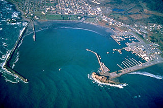
False Klamath is an unincorporated community in Del Norte County, California, on False Klamath Cove an inlet of the Pacific Ocean. It lies at an elevation of 36 feet (11 m).

Unincorporated area Region of land not governed by own local government

In law, an unincorporated area is a region of land that is not governed by a local municipal corporation; similarly an unincorporated community is a settlement that is not governed by its own local municipal corporation, but rather is administered as part of larger administrative divisions, such as a township, parish, borough, county, city, canton, state, province or country. Occasionally, municipalities dissolve or disincorporate, which may happen if they become fiscally insolvent, and services become the responsibility of a higher administration. Widespread unincorporated communities and areas are a distinguishing feature of the United States and Canada. In most other countries of the world, there are either no unincorporated areas at all, or these are very rare; typically remote, outlying, sparsely populated or uninhabited areas.
Del Norte County, California County in California ----

Del Norte County is a county at the far northwest corner of the U.S. state of California, along the Pacific Ocean adjacent to the Oregon border. As of the 2010 census, the population was 28,610. The county seat and only incorporated city is Crescent City. Del Norte was pioneered and settled by Azorean Portuguese explorers and dairy farmers, which may account for the local pronunciation of the county name. Residents pronounce the county name as Del Nort, not Del Nor-teh as would be expected in Spanish.

California State of the United States of America

California is a state in the Pacific Region of the United States. With 39.6 million residents, California is the most populous U.S. state and the third-largest by area. The state capital is Sacramento. The Greater Los Angeles Area and the San Francisco Bay Area are the nation's second and fifth most populous urban regions, with 18.7 million and 9.7 million residents respectively. Los Angeles is California's most populous city, and the country's second most populous, after New York City. California also has the nation's most populous county, Los Angeles County, and its largest county by area, San Bernardino County. The City and County of San Francisco is both the country's second-most densely populated major city after New York City and the fifth-most densely populated county, behind only four of the five New York City boroughs.

Related Research Articles

Salunga is a census-designated place located in Rapho and East Hempfield Townships in Lancaster County in the state of Pennsylvania. It is located along Pennsylvania Route 283 just outside the city of Lancaster. The community was once part of the Salunga-Landisville CDP, before splitting into two separate CDPs for the 2010 census, the other being Landisville. As of the 2010 census the population was 2,695 residents.

Klamath County, California County in the United States

Klamath County was a county of California from 1851 to 1874. During its existence, the county seat moved twice and ultimately portions of the territory it once had were carved up and added to nearby counties. It was formed from the northwestern portion of Trinity County, and originally included all of the northwestern part of the state, from the Mad River in the south to Oregon in the north, from the Pacific Ocean in the west to the middle of what is now Siskiyou County in the east. It is the only county in California to be disestablished.

The Resighini Rancheria, located just south of Klamath, California, is a Yurok Native American rancheria and a federally recognized tribe. It was formerly known as the Coast Indian Community of Yurok Indians of the Resighini Rancheria.

The Yurok Tribe of the Yurok Reservation' is located in parts of Del Norte and Humboldt counties, California, on a 44-mile (71 km) stretch of the Klamath River. It is a rancheria of Yurok people and a federally recognized tribe.

Popponesset Bay

Popponesset Bay System is a group of bays located at the towns of Mashpee and Barnstable (east), on Cape Cod, Massachusetts with a southern shore bounded by water from Nantucket Sound.

Djasr Kasentina Place in Algiers, Algeria

Gué de Constantine is a suburb of the city of Algiers in northern Algeria.

Bigfoot Trail

The Bigfoot Trail is an unofficial U.S. long-distance hiking trail in northern California. The Bigfoot Trail was originally proposed by Michael Kauffmann in 2009 as a suggested route to navigate the Klamath Mountains from south to north as well as a long-trail to introduce nature lovers to the biodiversity of the Klamath Mountains region. The trail begins in the Yolla Bolly-Middle Eel Wilderness and ends in Redwood National Park at the Pacific Ocean near Crescent City, California. A major focus along the trail is conifer diversity, passing 32 species in 360 miles (580 km). The route crosses six wilderness areas, one National Park, and one State Park. Northwest California's Klamath Mountains foster one of the most diverse temperate coniferous forests on Earth, and this route is intended to be a celebration of that biodiversity.

Camp Klamath, California Unincorporated community in California, United States

Camp Klamath is an unincorporated community in Del Norte County, California. It is located on the east bank of the Klamath River 1.5 miles (2.4 km) from its mouth, at an elevation of 23 feet.

Hoppaw, California Unincorporated community in California, United States

Hoppaw is an unincorporated community in Del Norte County, California. It is located on Hoppaw Creek 3 miles (4.8 km) east-southeast of the mouth of the Klamath River, at an elevation of 36 feet. It appears in the Requa U.S. Geological Survey Map.

Khwunrghunme, California Former settlement in California, United States

Khwunrghunme is a former Yurok settlement in Del Norte County, California, south of the mouth of Klamath River. It lay at an elevation of 33 feet.

Klamath Glen, California Unincorporated community in California, United States

Klamath Glen is an unincorporated community in Del Norte County, California. It is located on the Klamath River 5 miles (8 km) from its mouth, at an elevation of 46 feet.

Waukell Flat, California Former settlement in California, United States

Waukell Flat is a former settlement in Del Norte County, California. It was located on the south bank of the Klamath River 4.25 miles (6.8 km) from its mouth, at an elevation of 23 feet. It still appeared on maps as of 1952.

Eshpeu is a former Yurok settlement in Humboldt County, California. It was located at Gold Bluff between the mouths of the Klamath River and Redwood Creek. Espa Lagoon is near the site of Eshpeu.

Johnsons, California Unincorporated community in California, United States

Johnsons is an unincorporated community in Humboldt County, California. It is located on the Klamath River 14 miles (23 km) northwest of Weitchpec, at an elevation of 180 feet.

Martins Ferry, California Former settlement in California, United States

Martins Ferry is a former settlement in Klamath County and later in Humboldt County, California. It lay on the Klamath River, at an elevation of 315 feet. It still appeared on maps as of 1983.

The Klamath River is a river in southern Oregon and northern California in the United States. This article describes its course.

Klamath Air Force Station

Klamath Air Force Station is a closed United States Air Force General Surveillance Radar station. It is located 3.4 miles (5.5 km) northwest of Klamath, California. It was closed in 1981.

The Achulet Massacre was an 1854 massacre of more than 65 Tolowa people by European-American settlers at the village of Achulet near Lake Earl in Klamath County. In the years between 1845 and 1855, many Easterners and immigrants had migrated to California in the climactic years of the gold rush. This village developed as a huge shipping and trade center.

Wingate Bar, a former gold mining camp in Klamath County, California now located in Siskiyou County, California. Its location was 8 miles west of Happy Camp, California, along west bank of the Klamath River just east of Highway 96. It is now the location of P. Wingate Bar River Access of the Klamath National Forest.

References