Le Moyne, Quebec

Last updated

Le Moyne, Quebec
Neighbourhood
LeMoyne houses.jpg
Houses on Saint-Georges Street
Motto(s): 
"Droit et Loyal"  (French)
"Right and Loyal"
Region metropolitaine de Montreal-blank.svg
Red pog.svg
Le Moyne, Quebec
Location of Le Moyne in Greater Montreal
Coordinates: 45°30′07″N73°29′26″W / 45.501889°N 73.490611°W / 45.501889; -73.490611
CountryFlag of Canada (Pantone).svg  Canada
Province Flag of Quebec.svg  Quebec
City Longueuil
Borough Le Vieux-Longueuil
Established1949
Merger with LongueuilJanuary 1, 2002
Government
   Le Moyne-Jacques-Cartier City Councillor Colette Éthier (AL)
Area
  Land1.00 km2 (0.39 sq mi)
Population
 (2011) [2]
  Total4,813
  Density4,813.0/km2 (12,466/sq mi)
  Change *
Decrease2.svg7.0%
  Dwellings
2,815
Time zone UTC-5 (EST)
  Summer (DST) UTC-4 (EDT)
Area code 450
Access Routes [3] Qc112.svg R-112
Qc116.svg R-116
Qc134.svg R-134

Le Moyne (also known as Ville Le Moyne, formerly known as LeMoyne) is a neighbourhood in Longueuil, Quebec, part of the borough of Le Vieux-Longueuil, and a former city. Le Moyne makes up 2% of the total area of Le Vieux-Longueuil borough and is the only neighbourhood of the borough that was not part of the pre-2002 city of Longueuil. Residents of Le Moyne are called Le Moynois.

Contents

The municipal electoral district of Le Moyne-Jacques-Cartier corresponds to the territory of Le Moyne, along with a portion from the former city of Longueuil.

History

Saint-Maxime and Saint-Josaphat

Le Moyne is divided into two sections separated by Route 112. They are Saint-Maxime and Saint-Josaphat, the two Catholic parishes that are the ancestors of Le Moyne.

Route 112 is called Saint-Louis Street in Saint-Maxime. Saint-Maxime has the shape of rectangle and is located from Saint-Louis Street to the limits of Greenfield Park. Saint-Maxime Church, built in 1918, is on Charron Street.

In Saint-Josaphat, Route 112 is called Sir Wilfrid-Laurier Boulevard. Saint-Josaphat has the shape somewhat of a boomerang or a hockey stick, and is located from Sir Wilfrid Laurier Boulevard to the limits of the former city of Longueuil. Saint-Josaphat Church is located on De L'Église Street.

Town of Le Moyne

The town of Le Moyne was created in 1949 from the merger of two parishes, Saint-Josaphat and Saint-Maxime, both of which were previously located in Ville Jacques-Cartier. [4] According to local historian Michel Pratt, the name "Le Moyne" was chosen by Redmond Roche of the Union Nationale, in honour to Charles Le Moyne.

Le Moyne elected in 1981 Louise Gravel as its first female mayor. [5]

Motto

The last of motto of Le Moyne, before its annexation into Longueuil, was Droit et Loyal (English translation: Right and Loyal)

Town hall

Up until 1967, the town hall of Le Moyne was on Saint-Louis Street near Laurier Street. When located there, Le Moyne had its own police and fire stations.

In 1967, the town hall was moved on Saint-Georges Street (corner Charron Street), where it remained until the 2002 merger of Le Moyne with Longueuil. When Le Moyne moved its city hall in 1967, it did away with its police and fire services. From then on, these services were provided to Le Moyne, first by the city of Saint-Lambert, and later by the city of Saint-Hubert.

Today, the city hall on Saint-Georges Street has been converted as a fire station for the city of Longueuil.

Merger to Longueuil

On January 1, 2002, Le Moyne ceased to exist as a municipality and was amalgamated into the city of Longueuil to become part of the Saint-Lambert/Le Moyne borough.

However, on June 20, 2004 Saint-Lambert voted to demerge from Longueuil and on January 1, 2006 regained its status of city, while Le Moyne opted to stay in Longueuil.

After the demergers, Le Moyne joined Le Vieux-Longueuil borough following the results of a 2005 referendum in which the residents of Le Moyne were given the choice to pick a new borough between Le Vieux-Longueuil, Saint-Hubert and Greenfield Park.

Demographics

Apartments on Tiffin Road. LeMoyneQuebecApartments.jpg
Apartments on Tiffin Road.
Historical populations
YearPop.±%
19514,078    
19618,057+97.6%
19718,184+1.6%
19816,137−25.0%
19915,412−11.8%
1996 5,052−6.7%
2001 4,855−3.9%
2006 5,149+6.1%
2011 4,813−6.5%
[6] [7]
Mother tongue language (2006) [1]
LanguagePopulationPercentage (%)
French 4,18581.6%
English 4408.6%
Both English and French300.6%
Other languages4759.3%

Mayors

Former Mayors of Le Moyne
MayorTerm BeganTerm Ended
Henri Sicotte19491952
Albert Bélanger19521954
Jean Baribeau19541967
André Charpentier19671977
Michel Sicotte19771981
Louise Gravel19811993
Guy Talbot19932001
Part of Longueuil 2002present

Notable people

See also

45°30′6.8″N73°29′26.2″W / 45.501889°N 73.490611°W / 45.501889; -73.490611

Related Research Articles

<span class="mw-page-title-main">Longueuil</span> City in Quebec, Canada

Longueuil is a city in the province of Quebec, Canada. It is the seat of the Montérégie administrative region and the central city of the urban agglomeration of Longueuil. It sits on the south shore of the Saint Lawrence River directly across from Montreal. The population as of the Canada 2016 Census totalled 239,700, making it Montreal's second largest suburb, the fifth most populous city in Quebec and twentieth largest in Canada.

<span class="mw-page-title-main">Saint-Hubert, Quebec</span> Borough of Longueuil in Quebec, Canada

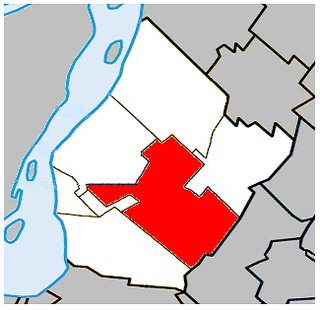
Saint-Hubert is a borough in the city of Longueuil, located in the Montérégie region of Quebec, Canada. It had been a separate city prior to January 1, 2002, when it along with several other neighbouring south shore municipalities were merged into Longueuil. Saint-Hubert had a population of 78,336 in 2006. The area of the borough is 65.98 km2 (25.48 sq mi). Longueuil's city hall is now located in Saint-Hubert. Saint-Hubert is located about 14 kilometres (8.7 mi) from downtown Montreal.

<span class="mw-page-title-main">Boucherville</span> City in Quebec, Canada

Boucherville is a city in the Montérégie region in Quebec, Canada. It is a suburb of Montreal on the South shore of the Saint Lawrence River.

<span class="mw-page-title-main">Greenfield Park, Quebec</span> Borough of Longueuil in Quebec, Canada

Greenfield Park is a former city in southwestern Quebec, Canada. It is currently a borough of the city of Longueuil. It covers an area of 4.78 square kilometres (1.85 sq mi), with a population of 16,733 at the 2016 census of Canada. Greenfield Park is the only borough of Longueuil that has an officially bilingual status. It is primarily a post-WWI suburban area. Like the other two boroughs, most of the buildings in Greenfield Park are single-family homes. Nearly all of the land in Greenfield Park is built on, making it Longueuil's most densely populated borough.

<span class="mw-page-title-main">Saint-Lambert, Montérégie</span> City in Quebec, Canada

Saint-Lambert is a city in southwestern Quebec, Canada, located on the south shore of the St. Lawrence River, opposite Montreal. It is part of the Urban agglomeration of Longueuil of the Montérégie administrative region.

<span class="mw-page-title-main">Saint-Lambert (electoral district)</span> Federal electoral district in Quebec, Canada

Saint-Lambert was a federal electoral district in the Canadian province of Quebec. It was first represented in the House of Commons of Canada in 1997. Its population in 2006 was 94,541. It has been replaced by Brossard—Saint-Lambert.

<span class="mw-page-title-main">Brossard</span> City in Quebec, Canada

Brossard is a municipality in the Montérégie region of Quebec, Canada and is part of the Greater Montreal area. According to the 2021 census, Brossard's population was 91,525. It shares powers with the urban agglomeration of Longueuil and was a borough of the municipality of Longueuil from 2002 to 2006.

<span class="mw-page-title-main">Saint-Bruno-de-Montarville</span> City in Quebec, Canada

Saint-Bruno-de-Montarville is an off-island suburb of Montreal, in southwestern Quebec, Canada, on the south bank of the Saint Lawrence River just east of Montreal. It lies on the west flank of Mont Saint-Bruno, one of the Monteregian Hills. The population as of the Canada 2011 Census was 26,107. It merged with Longueuil in 2002 but de-merged in 2006.

<span class="mw-page-title-main">Quebec Route 116</span> Highway in Quebec

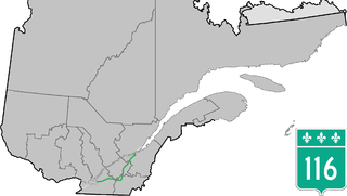
Route 116 is an east/west highway on the south shore of the St. Lawrence River in Quebec, Canada. It runs between Route 134 in Longueuil and Route 132 in Lévis, connecting the south shore areas of Montreal and Quebec City; it also serves the administrative regions of Montérégie, Centre-du-Québec, Estrie and Chaudière-Appalaches. Until the mid-1970s it was known as Route 9 between Le Moyne and Saint-Simon; Route 32 between Saint-Simon and Richmond; and Route 5 between Richmond and Saint-Nicolas.

<span class="mw-page-title-main">Montréal-Sud</span>

Montreal-South was a suburb of Montreal located on the south shore of the St. Lawrence River founded in 1906. Montréal-Sud was created from land of the Saint-Antoine-de-Longueuil parish. Originally a village in its first five years, Montréal-Sud gained the status of city in 1911.

<span class="mw-page-title-main">Le Vieux-Longueuil</span> Borough of Longueuil in Quebec, Canada

Le Vieux-Longueuil is a borough in the city of Longueuil.

Service de sécurité incendie de l'agglomération de Longueuil (SSIAL) is responsible for fire and rescue operations in Longueuil, Brossard, Saint-Lambert, Saint-Bruno-de-Montarville and Boucherville, Quebec, Canada.

<span class="mw-page-title-main">Laflèche, Quebec</span> Neighbourhood in Longueuil, Quebec, Canada

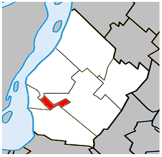
Laflèche is a neighbourhood in the Saint-Hubert borough of the city of Longueuil.

Ville Jacques-Cartier was a city located on the south shore of Montreal, Quebec, Canada. It was named after the founder of New France, Jacques Cartier. Now a defunct city, its former territory makes up a third of the city of Longueuil and more than 80% of Le Vieux-Longueuil borough.

<span class="mw-page-title-main">Urban agglomeration of Longueuil</span> Urban agglomeration in Quebec, Canada

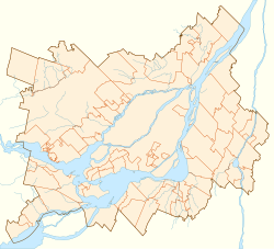
The urban agglomeration of Longueuil was created on January 1, 2006 as a result of the de-amalgamation process brought upon by the Charest government. It encompasses all the boroughs that were merged into the previous city of Longueuil and still retains the same area as that mega-city.

<i>Le Courrier du Sud</i> Free French-language weekly tabloid newspaper based in Longueuil, Quebec, Canada

Le Courrier du Sud is a free French-language weekly tabloid newspaper based in Longueuil, Quebec, Canada. The newspaper is distributed to 143,992 homes in the cities of Longueuil, Brossard and Saint-Lambert. 'Le Courrier du Sud is owned by Transcontinental. It was established in 1947 by Jean-Paul Auclair in the former city of Montreal South as a bilingual newspaper.

<span class="mw-page-title-main">Centre de services scolaire Marie-Victorin</span>

Centre de services scolaire Marie-Victorin (CSSMV) is a French-language school service centre operating in the Province of Quebec, Canada and serving the tables of Longueuil, Brossard and Saint-Lambert. CSSMV was established on July 1, 1998, and became one of the most important school centres in Quebec. The board's headquarters are in Longueuil.

<span class="mw-page-title-main">Parc Michel-Chartrand</span> Park in Quebec, Canada

Parc Michel-Chartrand, formerly known as the Parc régional de Longueuil, is a large park located in Longueuil, Quebec, Canada. It is located at 1895 Rue Adoncour in the borough of Le Vieux-Longueuil.

Commission scolaire Marie-Victorin (CSMV) was a French-language, school board operating in the Province of Quebec, Canada and serving the municipality of Longueuil, Brossard and Saint-Lambert. The board's headquarters are in Longueuil.

References

  1. 1 2 Moyne&SearchType=Begins&SearchPR=24&B1=Custom&Custom=1000,8000,9000 2006 Statistics Canada Community Profile
  2. 1 2 "Census Profile: Census Tract: 4620866.00". Canada 2011 Census . Statistics Canada. 8 February 2012. Retrieved 10 July 2012.
    "Census Profile: Census Tract: 4620865.00". Canada 2011 Census . Statistics Canada. 8 February 2012. Retrieved 10 July 2012.
  3. Official Transport Quebec Road Map
  4. "Chroniques de la Rive-Sud 1947-1997".
  5. "Document sans titre". marigot.ca. Archived from the original on 2003-09-07.
  6. Pratt, Michel. "De la balkanisation des villes à leur fusion". Société historique et culturelle du Marigot. Retrieved 24 October 2013.
  7. Statistics Canada: 1996, 2001, 2006, 2011 census