Related Research Articles

Cumbria is a ceremonial and non-metropolitan county in North West England, bordering Scotland. The county and Cumbria County Council, its local government, came into existence in 1974 after the passage of the Local Government Act 1972. Cumbria's county town is Carlisle, in the north of the county. The only other major urban area is Barrow-in-Furness on the south-western tip of the county.
Derwent derives from the Brythonic term Derventio, meaning "valley thick with oaks". It may refer to:

Westmorland is a historic county in North West England. It formed an administrative county between 1889 and 1974, after which the whole county was administered by the new administrative and ceremonial county of Cumbria. The people of Westmorland are known as Westmerians. In April 2023, it is planned that local government in Cumbria will be reorganised into two unitary authorities, one of which is to be named Westmorland and Furness and would cover all of the historic county along with parts of historic Yorkshire, Lancashire and Cumberland.

Workington is a coastal town and civil parish at the mouth of the River Derwent on the west coast in the Allerdale borough of Cumbria, England. The town was historically in Cumberland. At the 2011 census it had a population of 25,207.
Cumberland is a historic county in North West England that had an administrative function from the 12th century until 1974. It is bordered by the historic counties of Northumberland to the north-east, County Durham to the east, Westmorland to the south-east, Lancashire to the south, and the Scottish counties of Dumfriesshire and Roxburghshire to the north. It formed an administrative county from 1889 to 1974 and now forms part of Cumbria. In April 2023, local government in Cumbria will be reorganised into two unitary authorities; one of these is to be named Cumberland and would include most of the historic county, with the exception of Penrith and the surrounding area.

The Borough of Copeland is a local government district and borough in western Cumbria, England. Its council is based in Whitehaven. It was formed on 1 April 1974 by the merger of the Borough of Whitehaven, Ennerdale Rural District and Millom Rural District. The population of the Non-Metropolitan district was 69,318 according to the 2001 census, increasing to 70,603 at the 2011 Census.

Allerdale is a non-metropolitan district of Cumbria, England, with borough status. Its council is based in Workington and the borough has a population of 93,492 according to the 2001 census, increasing to 96,422 at the 2011 Census.
Eden is a local government district in Cumbria, England, based at Penrith Town Hall in Penrith. It is named after the River Eden, which flows north through the district toward Carlisle. Its population of 49,777 at the 2001 census, increased to 52,564 at the 2011 Census. A 2019 estimate was 53,253. In July 2021 it was announced that in April 2023, Cumbria will divide into two unitary authorities. Eden District Council will cease and its functions pass to a new authority, Westmorland and Furness, covering the current districts of Barrow-in-Furness, Eden and South Lakeland.

Eskdale is a glacial valley and civil parish in the western Lake District National Park in Cumbria, England. It forms part of the Borough of Copeland, and in 2001 had a population of 264, increasing to 304 at the 2011 Census. One of the Lake District's most popular tourist attractions, the Ravenglass and Eskdale Railway, runs through the valley, though along with other western valleys of the Lake District, Eskdale is notably quieter during the high summer season than the more accessible eastern areas.
Penrith and The Border is a constituency in Cumbria represented in the House of Commons of the UK Parliament since 2019 by Neil Hudson, a Conservative.

Alston Moor, formerly known as Alston with Garrigill, is a civil parish and electoral ward in Cumbria, England, based around the small town of Alston. It is set in the moorlands of the North Pennines, mostly at an altitude of over 1000 feet. The parish/ward had a population of 2,088 at the 2011 census. As well as the town of Alston, the parish includes the villages of Garrigill and Nenthead, along with the hamlets of Nenthall, Nentsberry, Galligill, Blagill, Ashgill, Leadgate, Bayles and Raise. Alston Moor is part of the North Pennines Area of Outstanding Natural Beauty (AONB), the second largest of the 40 AONBs in England and Wales.

Broughton Moor is a village and civil parish in the Borough of Allerdale in Cumbria, England. It is situated on an extensive moor about 2 miles (3.2 km) north of Broughton, 5 miles (8.0 km) north west of Cockermouth, 2.5 miles (4.0 km) south of Maryport and 4.5 miles (7.2 km) north of Workington.
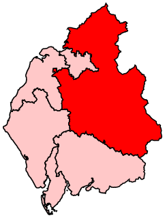
Penrith was a rural district within the administrative county of Cumberland, England that existed from 1894 to 1974 with slight boundary changes in 1934.
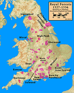
Inglewood Forest is a large tract of mainly arable and dairy farm land with a few small woodland areas between Carlisle and Penrith in the English non-metropolitan county of Cumbria or ancient county of Cumberland.
Eskdale was a parliamentary constituency centred on the Eskdale, district of north Cumberland not to be confused with the valley of Eskdale in the west of the county. It returned one Member of Parliament (MP) to the House of Commons of the Parliament of the United Kingdom, elected by the first past the post system.
West Cumberland was a county constituency in the House of Commons of the Parliament of the United Kingdom. It elected two Members of Parliament (MPs) by the bloc vote system of election.

Dearham is a village and civil parish in the Allerdale district of Cumbria, historically part of Cumberland, near the Lake District National Park in England. It lies about 2 miles (3.2 km) east of Maryport and 5 miles (8.0 km) west of Cockermouth.

Camerton is a small village and civil parish in Cumbria, historically part of Cumberland, near the Lake District National Park in England. According to older maps, it was originally called "Camberton".

Redmain is a small hamlet in the Isel Valley and parish of Blindcrake within the Lake District National Park in Cumbria, England. The hamlet lies on the south-facing slopes above the River Derwent, in an elevated position of 475 feet (145 m), giving panoramas across the Isel Valley and Lake District Fells. Nearby are the hamlets of Isel and Sunderland and the village of Blindcrake.

Setmurthy is a civil parish in Allerdale, Cumbria, England, historically part of Cumberland, within the Lake District National Park in England. In the 2011 census it had a population of 110. The spelling "Satmurthawe" is seen in 1473.
References
- ↑ "A Vision of Britain Through Time: Leath". www.visionofbritain.co.uk. GB Historical GIS/University of Portsmouth. Retrieved 18 March 2016.
Coordinates: 54°36′N2°42′W / 54.6°N 2.7°W
| | This Cumbria location article is a stub. You can help Wikipedia by expanding it. |