
Sonoma County is a county in the U.S. state of California. As of the 2010 United States Census, its population was 483,878. Its county seat and largest city is Santa Rosa. It is to the north of Marin County and the south of Mendocino County. It is west of Napa County and Lake County.

Wine Country is the region of California, in the northern Bay Area, known worldwide as a premium wine-growing region. The region is famed for its wineries, its cuisine, Michelin star restaurants, boutique hotels, luxury resorts, historic architecture, and culture. Viticulture and wine-making have been practiced in the region since the Spanish missionaries from Mission San Francisco Solano established the first vineyards in 1812.

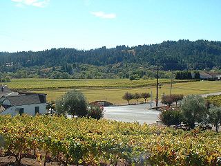
Sonoma Valley is a valley located in southeastern Sonoma County, California, in the San Francisco Bay Area. Known as the birthplace of the California wine industry, the valley is home to some of the earliest vineyards and wineries in the state, some of which survived the phylloxera epidemic of the 1870s and the impact of prohibition in the early 20th century. Today, the valley's wines are protected by the US Federal Government's Sonoma Valley and Carneros AVAs.
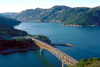
Lake Sonoma is a reservoir west of Cloverdale in northern Sonoma County, California, created by the construction of Warm Springs Dam. Access from U.S. Route 101 is by way of Canyon Road from Geyserville, or Dutcher Creek Road from Cloverdale.
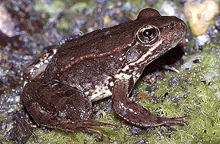
The California red-legged frog is a species of frog found in California (USA) and northern Baja California (Mexico). It was formerly considered a subspecies of the northern red-legged frog. The frog is an IUCN vulnerable species, and a federally listed threatened species of the United States, and is protected by law.
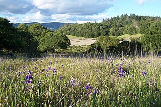
Trione-Annadel State Park is a state park of California in the United States. It is situated at the northern edge of Sonoma Valley and is adjacent to Spring Lake Regional Park in Santa Rosa. It offers many recreational activities within its 5,092-acre (2,061 ha) property.

Malibu Creek is a year-round stream in western Los Angeles County, California. It drains the southern Conejo Valley and Simi Hills, flowing south through the Santa Monica Mountains, and enters Santa Monica Bay in Malibu, California. The Malibu Creek watershed drains 109 square miles (280 km2) and its tributary creeks reach as high as 3,000 feet (910 m) into Ventura County, California. The creek's mainstem begins south of Westlake Village at the confluence of Triunfo Creek and Lobo Canyon Creek, and flows 13.4 miles (21.6 km) to Malibu Lagoon.

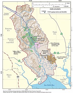
Sonoma Creek is a 33.4-mile-long (53.8 km) stream in northern California. It is one of two principal drainages of southern Sonoma County, California, with headwaters rising in the rugged hills of Sugarloaf Ridge State Park and discharging to San Pablo Bay, the northern arm of San Francisco Bay. The watershed drained by Sonoma Creek is roughly equivalent to the wine region of Sonoma Valley, an area of about 170 square miles (440 km2). The State of California has designated the Sonoma Creek watershed as a “Critical Coastal Water Resource”. To the east of this generally rectangular watershed is the Napa River watershed, and to the west are the Petaluma River and Tolay Creek watersheds.

Mount Hood, also known as Hood Mountain is a mountain near the southeastern edge of Santa Rosa, California at the northeast of the Sonoma Valley and attains a height of 2,733 feet (833 m). The original name was Mount Wilikos, an Indian name meaning "willows." Most of the drainage from Mount Hood contributes to the headwaters of Sonoma Creek. A prominent feature is the extensive rock face visible on the upper half of the mountain as viewed from State Route 12. The habitats on the mountain include mixed oak forest, pygmy forest, chaparral and riparian zones. In prehistoric times the slopes of Mount Hood were inhabited by a division of the Yuki tribe. Most of Mount Hood is within the Hood Mountain Regional Park maintained by Sonoma County. Mount Hood is part of the inner coast Mayacamas Range, and lies mostly within Sonoma County, with a part of the mountain geographically within Napa County. Mount Hood affords overlooks of the Pacific Ocean, San Francisco Bay and "a spectacular view east to the Sierra Nevada Range."

The Fairfield Osborn Preserve is a 450 acre nature reserve situated on the northwest flank of Sonoma Mountain in Sonoma County, California. There are eight plant communities within the property, oak woodland being the dominant type. Other communities include chaparral, Douglas fir woodland, native Bunch grass, freshwater marsh, vernal pool, pond and riparian woodland. The flora is extremely diverse including many native trees, shrubs, wildflowers, grasses, lichens and mosses. A diverse fauna inhabits this area including black-tailed deer, coyote, bobcat and an occasional mountain lion; moreover, there are abundant avifauna, amphibians, reptiles and insects.

Yulupa Creek is a 2.8-mile-long (4.5 km) southeast-flowing perennial stream that rises on the southeastern flanks of the northern Sonoma Mountains in Sonoma County, California, United States. This creek, which drains the eastern slopes of Bennett Mountain, is tributary to Sonoma Creek, which in turn discharges to San Pablo Bay.

Tolay Lake is a shallow freshwater lake in southern Sonoma County, California, United States. The lake, nestled within the southern vestiges of the Sonoma Mountains, is the site of significant Native American prehistoric seasonal settlement. In 2005, Sonoma County acquired the entirety of the lake and virtually its whole drainage basin from the Cardoza family for the sum of $18 million; the County's intention is to utilize the property as Tolay Lake Regional Park for ecological and archaeological preservation, as well as public use and enjoyment. Tolay Lake and its immediate drainage area is home to several nesting pairs of golden eagles, Aquila chrysaetos, and a number of rare, threatened or endangered species including the California red-legged frog, Rana draytonii; Western pond turtle, Actinemys marmorata; and Western burrowing owl, Athene cunicularia.

Lake Ilsanjo is a man-made lake located in Annadel State Park east of Santa Rosa in Sonoma County, California, United States. It is a place for fishing and swimming, especially in the summer months. Entrepreneur Joe Coney originally owned the land that is now Annadel State Park and named the lake after his wife Ilsa and himself. Thus it came to be called Lake Ilsanjo. It drains into Spring Creek.
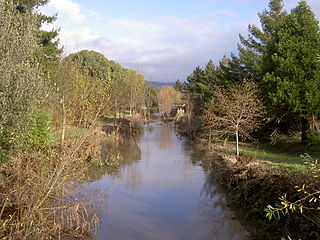
Hinebaugh Creek is a westward-flowing stream in western Sonoma County within the Laguna de Santa Rosa watershed. As this watercourse proceeds westerly through the city of Rohnert Park, it has largely been channelized and courses in an artificially straight alignment. Considered waters of the United States as a jurisdictional matter, Hinebaugh Creek is potential habitat for the California red-legged frog and the Western pond turtle. The dominant riparian vegetation is Himalayan blackberry and willow.

Five Creek is a westward flowing stream that rises in the city of Rohnert Park, California, United States and discharges to the Laguna de Santa Rosa. The creek is channelized as it flows through the city and runs in an artificially rectilinear fashion. Considered waters of the United States as a jurisdictional matter, Five Creek has potential habitat for the California red-legged frog and the Western pond turtle.
The Dry Creek Valley AVA is an American Viticultural Area in Sonoma County, California, located northwest of the town of Healdsburg. The valley is formed by Dry Creek, a tributary of the Russian River, and is approximately 16 miles (25.7 km) long and 2 miles (3.2 km) wide. The appellation benefits from the proximity of the Lake Sonoma reservoir for irrigation in this relatively dry area.

Bennett Mountain, also commonly known as Bennett Peak, is a 1,909-foot (582 m) summit in the Sonoma Mountains of California. Located on the west edge of Annadel State Park, it separates Bennett Valley in the Russian River drainage basin from Sonoma Valley in the Sonoma Creek drainage basin.
Sonoma Water, formerly known as the Sonoma County Water Agency, maintains a water transmission system that provides naturally filtered Russian River water to more than 600,000 residents in portions of Sonoma County, California and Marin County, California. The Water Agency is a water wholesaler that sells potable water to nine cities and special districts that in turn sell drinking water to their residents. These cities and special districts are: the City of Santa Rosa, Rohnert Park, Cotati, Petaluma, Sonoma, the Town of Windsor, Valley of the Moon Water District, Marin Municipal Water District, and North Marin Water District.

Corte Madera Creek is a 7.3-mile-long (11.7 km) creek that flows north-northwest to Searsville Dam and then joins with Bear Creek to form San Francisquito Creek in California.
The 40-acre Los Guillicos Preserve lies in the Valley of the Moon at the foot of Hood Mountain in the Mayacamas Mountain Range. Oak woodlands of the Preserve are within the Sonoma Creek Watershed. This land was included in the 1837 Rancho Los Guilicos Mexican Land Grant. Since 2011, the Preserve has been managed by Sonoma State University's Center for Environmental Inquiry.

