Lee, Indiana

Last updated

Lee, Indiana
Lee, Indiana grain.jpg
View north from Madison Street toward corn fields and grain elevators
USA Indiana location map.svg
Red pog.svg
Lee
Usa edcp location map.svg
Red pog.svg
Lee
Coordinates: 40°53′47″N86°58′05″W / 40.89639°N 86.96806°W / 40.89639; -86.96806
Country United States
State Indiana
County White
Township Monon
Established1883
PlattedAugust 1886
Named for John Lee
Elevation
[1]
673 ft (205 m)
Time zone UTC-5 (Eastern (EST))
  Summer (DST) UTC-4 (EDT)
ZIP code
47978
FIPS code 18-42642 [2]
GNIS feature ID 437727

Lee is an unincorporated community in Monon Township, White County, in the U.S. state of Indiana. [3] [4]

Contents

History

The site of what is now Lee is first recorded as a station stop on the Indianapolis, Delphi and Chicago Railroad, [5] a company which by late 1879 had completed its initial 40-mile stretch of railroad connecting Rensselaer and Delphi. [6] The following year on 25 October [7] a post office was established at the location to serve the rural districts northwest of Monon with Calvin Anderson as its first postmaster. [8] [9] Around 1884 the railroad became known as the Monon Route. [6] [10]

Lee was established in 1883 and named for John Lee, the president of the ID&C Railroad, who opened a grain market there. [11] [5] Lee's location in the northwestern portion of the county [12] was "a rich district of drained lands, admirably adapted to live stock," and as well as a place for marketing and shipping grain it was also an important local shipping point for hay; a 1915 history notes that hundreds of tons were baled and shipped annually. [13]

In August 1886 the location was platted under the name of Oakdale by Noble J. York, a local businessman and president of the Monon town board, [14] and Benjamin A. Linville, but it was generally known as Lee. [13] In 1949, a petition led to one of Lee's street being vacated . [15] [16]

Lee's post office closed on 30 June 1933. [7] [17] The line through Lee is now part of CSX Transportation Monon Subdivision [18] and is used by Amtrak. While shown on Amtrak maps, service provided on the Cardinal (and previously also on the Hoosier State ) does not stop at Lee. [19]

In 2016, Helen Louise George, an 88-year resident of the area, published History and Reflections of Lee, Indiana which chronicles the history of Lee. [20]

Geography

Lee is located at 40°53′47″N86°58′05″W / 40.89639°N 86.96806°W / 40.89639; -86.96806 about 5 miles (8.0 km) northwest of Monon [8] [13] near the intersection of County Roads 1000 North and 500 West [21] and on the rail line between Monon and Rensselaer. [18] [22] The surrounding farmland is drained by Slough Creek, a tributary of the Iroquois River [23] that flows just south of Lee in a westward direction.

Related Research Articles

<span class="mw-page-title-main">Warren County, Indiana</span> County in Indiana, United States

Warren County is a county in the U.S. state of Indiana. It lies in the western part of the state between the Illinois state line and the Wabash River. According to the 2020 census, it had a population of 8,440. Its county seat is Williamsport.

<span class="mw-page-title-main">Medaryville, Indiana</span> Town in Indiana, United States

Medaryville is a town in White Post Township, Pulaski County, in the U.S. state of Indiana. The population was 614 at the 2010 census.

<span class="mw-page-title-main">Monon, Indiana</span> Town in Indiana, United States

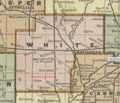
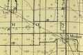
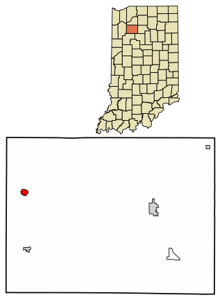
Monon is a town in Monon Township, White County, in the U.S. state of Indiana. The population was 1,777 at the 2010 census.

<span class="mw-page-title-main">Monon Railroad</span> Defunct American Class I railway

The Monon Railroad, also known as the Chicago, Indianapolis, and Louisville Railway from 1897 to 1971, was an American railroad that operated almost entirely within the state of Indiana. The Monon was merged into the Louisville and Nashville Railroad in 1971, and much of the former Monon right of way is owned today by CSX Transportation. In 1970, it operated 540 miles (870 km) of road on 792 miles (1,275 km) of track; that year it reported 1320 million ton-miles of revenue freight and zero passenger-miles.

<span class="mw-page-title-main">Monon Trail</span> Shared-use path and rail trail in the U.S. state of Indiana

The Monon Trail is a rail trail located entirely within the state of Indiana. The Monon Railroad was a popular railroad line connecting the cities of Chicago and Indianapolis, with stops at major settlements along its route. After the decline of railroad travel and the sale of the company in 1987, the portion of the line between Indianapolis and Delphi, Indiana, was abandoned.

<i>Kentucky Cardinal</i>

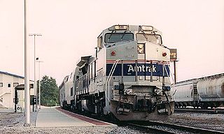
The Kentucky Cardinal was a nightly 312-mile (502 km) passenger train operated by Amtrak from 1999 to 2003 between Chicago, Illinois, and Louisville, Kentucky, via Indianapolis, Indiana. On the three days that the Cardinal ran, the Kentucky Cardinal operated as a section, splitting at Indianapolis. On the other four days, it ran on its own to Chicago.

The Indiana Rail Road is a United States Class II railroad, originally operating over former Illinois Central Railroad trackage from Newton, Illinois, to Indianapolis, Indiana, a distance of 155 miles (249 km). This line, now known as the Indiana Rail Road's Indianapolis Subdivision, comprises most of the former IC/ICG line from Indianapolis to Effingham, Illinois; Illinois Central successor Canadian National Railway retains the portion from Newton to Effingham. INRD also owns a former Milwaukee Road line from Terre Haute, Indiana, to Burns City, Indiana, with trackage rights extending to Chicago, Illinois. INRD no longer serves Louisville, Kentucky, and the Port of Indiana on the Ohio River at Jeffersonville, Indiana, through a haulage agreement with the Louisville & Indiana Railroad (LIRC).

<span class="mw-page-title-main">Indianapolis Union Station</span> Historic train station in Indianapolis, Indiana, U.S.

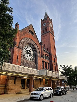
The Indianapolis Union Station is an intercity train station in the Wholesale District of Indianapolis, Indiana. The terminal is served by Amtrak's Cardinal line, passing through Indianapolis three times weekly.

<span class="mw-page-title-main">Crawfordsville station</span>

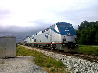
Crawfordsville station is an Amtrak intercity rail station in Crawfordsville, Indiana, served by the Cardinal.

<span class="mw-page-title-main">Rensselaer station</span> Train station in Indiana, USA

Rensselaer station is an Amtrak station in Rensselaer, Indiana, served by the Cardinal.

<i>Hoosier State</i> (train) Amtrak train route between Chicago, Illinois and Indianapolis, Indiana

The Hoosier State was a 196-mile (315 km) passenger train service operated by Amtrak between Chicago and Indianapolis. It ran on the four days each week that the Cardinal did not run, giving daily rail service to the Chicago–Indianapolis corridor.

<span class="mw-page-title-main">Honey Creek Township, White County, Indiana</span> Township in Indiana, United States

Honey Creek Township is one of twelve townships in White County, Indiana, United States. As of the 2010 census, its population was 1,162 and it contained 509 housing units.

<span class="mw-page-title-main">Monon Township, White County, Indiana</span> Township in Indiana, United States

Monon Township is one of twelve townships in White County, Indiana, United States. As of the 2010 census, its population was 3,282 and it contained 2,032 housing units.

<span class="mw-page-title-main">Kirklin Township, Clinton County, Indiana</span> Township in Indiana, United States

Kirklin Township is one of fourteen townships in Clinton County, Indiana. As of the 2010 census, its population was 1,380 and it contained 556 housing units.

<span class="mw-page-title-main">Beaver Township, Pulaski County, Indiana</span> Township in Indiana, United States

Beaver Township is one of twelve townships in Pulaski County, Indiana, United States. As of the 2010 census, its population was 516 and it contained 216 housing units.

<span class="mw-page-title-main">Salem Township, Pulaski County, Indiana</span> Township in Indiana, United States

Salem Township is one of twelve townships in Pulaski County, Indiana, United States. As of the 2010 census, its population was 1,399, and it contained 602 housing units.

<span class="mw-page-title-main">Cambria, Indiana</span> Unincorporated community in Indiana, United States

Cambria is an unincorporated community in Owen Township, Clinton County, Indiana.

Dinwiddie is an unincorporated community in Eagle Creek Township, Lake County, Indiana.

Elliston is an unincorporated community in Fairplay Township, Greene County, Indiana, United States.

The Indianapolis Union Railway Company, is a terminal railroad operating in Indianapolis, Indiana. It was organized on May 31, 1850, as the Union Track Railway Company by the presidents of the Madison and Indianapolis Railroad (M&I), the Terre Haute and Richmond Railroad (TH&R), and the Indianapolis and Bellefontaine Railroad (I&B) for the purposes of establishing and operating joint terminal facilities in Indiana's capital city. The name of the company was changed to its present one on August 12, 1853. The next month, on September 20, Indianapolis Union Station opened its doors, becoming the first union railroad station in the world. Since 1999, the company has been owned and operated by CSX.

References

  1. "US Board on Geographic Names". United States Geological Survey. October 25, 2007. Retrieved July 6, 2016.
  2. "U.S. Census website". United States Census Bureau . Retrieved January 31, 2008.
  3. "Lee, Indiana". Geographic Names Information System . United States Geological Survey . Retrieved July 24, 2017.
  4. "Indiana Roadway Map" (PDF). Indiana Department of Transportation. 2021. Retrieved September 16, 2022.
  5. 1 2 "Monon Railroad Historical Technical Society: McCoysburg" . Retrieved September 10, 2022. Lee. MP 83.1 1st Subdivision. Named for the President of the Indianapolis, Delphi and Chicago Railroad, John Lee, this community was founded in 1883. The station name appears on timetables of the ID&C as early as 1878. The community was a grain market.
  6. 1 2 The Indianian, Volumes 3-4, Indiana Trustees' Association, 1898, pp. 414–415, In 1872 a company was organized to construct a narrow gauge railroad from Indianapolis to Chicago, under the title of the Indianapolis, Delphi and Chicago Railroad. By the latter part of 1879 about forty miles of this projected road, that part running from Delphi to Rensselaer, was built and opened for traffic.
  7. 1 2 Baker, Ronald L. (1995), From Needmore to Prosperity, Indiana University Press, p. 194, A post office was established on October 25, 1880; closed on June 30, 1933. The village was named for John Lee, president of the Indianapolis, Delphi, and Chicago Railroad, who developed a grain market here.
  8. 1 2 Goodspeed, Weston Arthur (1883), Counties of White and Pulaski, Indiana: Historical and Biographical, F. A. Battey & Co.; reproduced by Unigraphic, p. 172, Lee Post Office, in the northwest corner of the township, was established about the year 1880. The first Postmaster was Calvin Anderson. He was succeeded, late in 1882, by Mr. Hoover, the present encumbent.
  9. Bass, Cotter (2020), The Treasure Hunter's Guide To Indiana's Lost & Buried Treasures: Plus Ghost Towns & Historic Sites, BookRix, ISBN   9783748767732
  10. "Monon Route" (PDF). Chicago, Indianapolis, and Louisville Railway. 1947. Retrieved September 7, 2022.
  11. Baker, Ronald L.; Carmony, Marvin (1975), Indiana Place Names, Indiana University Press, p. 89, Lee, village in White County. Established in 1883 as a grain market by John Lee, president of the Indianapolis, Delphi, and Chicago Railroad and named for him.
  12. Carroll-White Counties Indiana Official Plat Book 2010: Including Index of Owners, City Street Maps (10th ed.), Laporte, Indiana: Athentic, Inc., 2010, p. 57
  13. 1 2 3 Hamelle, W. H. (1915), A Standard History of White County, Indiana: An Authentic Narrative of the Past, with an Extended Survey of Modern Developments in the Progress of Town and Country, University of Wisconsin - Madison, pp. 209–210, The only existing postoffice in Monon Township outside the village is Lee, in the northwest corner, about a mile from the Jasper County line on the Louisville, New Albany & Chicago (Monon) Railroad... In August of [1886] it was platted by Benjamin A. Linville and Noble J. York, who laid out 120 lots on fractions of sections 3, 10 and 11, township 28 north, range 5 west. It is about five miles northwest of Monon and is the center of a rich district of drained lands, admirably adapted to live stock... Oakdale, or Lee, is an important shipping point for hay. Hundreds of tons are baled at the station every year and shipped abroad, and, with the improvement of the surrounding farming lands, it has become an equally good point for the marketing and shipping of grain.
  14. Biographical History of Tippecanoe, White, Jasper, Newton, Benton, Warren and Pulaski Counties, Indiana, Volume 2, Chicago: Lewis Publishing Company, 1899, pp. 821–823
  15. "School Teachers..." Journal and Courier (at Newspapers.com). July 8, 1949. p. 6.
  16. "Board will review White tax budgets". Journal and Courier (at Newspapers.com). September 10, 1949. p. 10.
  17. "White County". Jim Forte Postal History. Retrieved July 6, 2016. Lee (1880-1933)
  18. 1 2 "Indiana Railroad System" (PDF). Indiana Geological Survey (Appendix). 2007. Retrieved September 7, 2022.
  19. "Cardinal". Amtrak. 2022. Retrieved September 19, 2022.
  20. Sievers, Caitlin (December 27, 2016). "Area senior publishes first book at 88 years old". Herald Journal. Monticello, Indiana. Retrieved September 8, 2022.
  21. Boyd, Gregory A. (2010), Family Maps of White County, Indiana: with homesteads, roads, waterways, towns, cemeteries, railroads, and more, Arphax Publishing, ISBN   978-1-4203-2023-7, Map D Index: Cities and Towns of White County Indiana: Lee.
  22. Railroad map of Indiana (Map). 1:570,240. Indiana State Board of Tax Commissioners. c. 1896. Retrieved September 11, 2022.
  23. "Iroquois Watershed" (PDF). NRCS Field Office Technical Guide. USDA. Winter 2013. Retrieved September 10, 2022.