Burnettsville, Indiana | |
---|---|
![]() Location of Burnettsville in White County, Indiana. | |
Coordinates: 40°45′40″N86°35′41″W / 40.76111°N 86.59472°W [1] | |
Country | United States |
State | Indiana |
County | White |
Township | Jackson |
Area | |
• Total | 0.75 sq mi (1.93 km2) |
• Land | 0.75 sq mi (1.93 km2) |
• Water | 0.00 sq mi (0.00 km2) |
Elevation | 709 ft (216 m) |
Population (2020) | |
• Total | 390 |
• Density | 522.79/sq mi (201.96/km2) |
Time zone | UTC-5 (EST) |
• Summer (DST) | UTC-5 (EST) |
ZIP code | 47926 |
Area code | 574 |
FIPS code | 18-09316 [3] |
GNIS feature ID | 2396620 [1] |
Burnettsville is a town in Jackson Township, White County, in the U.S. state of Indiana. [4] The population was 346 at the 2010 census.
Burnettsville was laid out in 1854, [5] and was named after the nearby Burnetts Stream. [6]
A post office was first established in the community under the name Burnett's Creek, [7] which ran from 1837 to 1922. [8]
According to the 2010 census, Burnettsville has a total area of 0.75 square miles (1.94 km2), all land. [9]
Census | Pop. | Note | %± |
---|---|---|---|
1860 | 222 | — | |
1870 | 270 | 21.6% | |
1880 | 296 | 9.6% | |
1890 | 479 | 61.8% | |
1900 | 497 | 3.8% | |
1910 | 489 | −1.6% | |
1920 | 517 | 5.7% | |
1930 | 402 | −22.2% | |
1940 | 436 | 8.5% | |
1950 | 457 | 4.8% | |
1960 | 452 | −1.1% | |
1970 | 510 | 12.8% | |
1980 | 496 | −2.7% | |
1990 | 401 | −19.2% | |
2000 | 373 | −7.0% | |
2010 | 346 | −7.2% | |
2020 | 390 | 12.7% | |
U.S. Decennial Census [10] |
As of the census [11] of 2010, there were 346 people, 153 households, and 101 families living in the town. The population density was 461.3 inhabitants per square mile (178.1/km2). There were 170 housing units at an average density of 226.7 per square mile (87.5/km2). The racial makeup of the town was 98.3% White, 0.3% African American, 0.3% Asian, and 1.2% from two or more races.
There were 153 households, of which 24.2% had children under the age of 18 living with them, 52.3% were married couples living together, 9.8% had a female householder with no husband present, 3.9% had a male householder with no wife present, and 34.0% were non-families. 29.4% of all households were made up of individuals, and 15.1% had someone living alone who was 65 years of age or older. The average household size was 2.26 and the average family size was 2.77.
The median age in the town was 42.8 years. 21.4% of residents were under the age of 18; 6.9% were between the ages of 18 and 24; 24.3% were from 25 to 44; 30.3% were from 45 to 64; and 17.1% were 65 years of age or older. The gender makeup of the town was 46.5% male and 53.5% female.
As of the census [3] of 2000, there were 373 people, 155 households, and 113 families living in the town. The population density was 504.6 inhabitants per square mile (194.8/km2). There were 160 housing units at an average density of 216.5 per square mile (83.6/km2). The racial makeup of the town was 98.93% White, and 1.07% from two or more races. Hispanic or Latino of any race were 0.80% of the population.
There were 155 households, out of which 30.3% had children under the age of 18 living with them, 60.6% were married couples living together, 9.0% had a female householder with no husband present, and 26.5% were non-families. 23.2% of all households were made up of individuals, and 10.3% had someone living alone who was 65 years of age or older. The average household size was 2.41 and the average family size was 2.80.
In the town, the population was spread out, with 22.5% under the age of 18, 7.5% from 18 to 24, 27.1% from 25 to 44, 27.1% from 45 to 64, and 15.8% who were 65 years of age or older. The median age was 41 years. For every 100 females, there were 98.4 males. For every 100 females age 18 and over, there were 90.1 males.
The median income for a household in the town was $36,563, and the median income for a family was $45,625. Males had a median income of $30,982 versus $21,667 for females. The per capita income for the town was $22,005. About 6.6% of families and 9.0% of the population were below the poverty line, including 15.7% of those under age 18 and 11.5% of those age 65 or over.
Each year Burnettsville holds its Community Day in September. [12] The day's events include the Fireman's Breakfast, garage sales, 5K-10k Bee Bumble race, 1k-Bee Stingers race (for the kids) Ron's famous Ham and Beans, Cake Walk, over 60 vendors, entertainment on the stage all day, kids games, bounce house, balloons, parade, and fish fry. This and other events are held in the maintained old Burnettsville High School Gym, locally known as the "Bee Hive", the teams being known as the Burnettsville "Bees", before the consolidation of the White County Schools in 1962.
Alton is a town in Boone Township, Crawford County, Indiana, United States. The population was 29 at the 2020 census.
Ashley is a town in Indiana located on the border of Smithfield Township, DeKalb County and Steuben Township, Steuben County. The population was 983 at the 2010 census.
Lyons is a town in Washington Township, Greene County, Indiana, United States. The population was 742 at the 2010 census. It is part of the Bloomington, Indiana Metropolitan Statistical Area.
Spring Lake is a town in Sugar Creek Township, Hancock County, Indiana, United States, along Sugar Creek. The population was 218 at the 2010 census.
Stilesville is a town in Franklin Township, Hendricks County, Indiana, United States. The population was 316 at the 2010 Census.
Kennard is a town in Greensboro Township, Henry County, Indiana, United States. The population was 451 at the 2020 census.
Straughn is a town in Dudley Township, Henry County, Indiana, United States. The population was 259 at the 2020 census.
Andrews is a town in Dallas Township, Huntington County, Indiana, United States. The population was 1,048 at the 2020 census.
Bargersville is a town in White River and Union townships, Johnson County, Indiana, United States. The population was 9,560 at the 2020 census.
Prince's Lakes is a town in Nineveh Township, Johnson County, Indiana, United States. The population was 1,312 at the 2010 census.
Etna Green is a town in Etna Township, Kosciusko County, in the U.S. state of Indiana. The population was 586 at the 2010 census.
Ingalls is a town in Green Township, Madison County, Indiana, United States. It is part of the Indianapolis–Carmel–Anderson metropolitan statistical area. The population was 2,223 at the 2020 census.
Bethany is a town in Clay Township, Morgan County, in the U.S. state of Indiana. The population was 95 at the 2020 census.
Paragon is a town in Ray Township, Morgan County, in the U.S. state of Indiana. The population was 556 at the 2020 census, down from 659 in 2010.
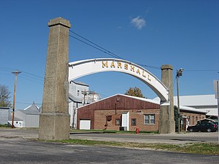
Marshall is a town in Washington Township, Parke County, Indiana, United States. As of the 2010 census, the population was 324.
Fillmore is a town in Marion Township, Putnam County, in the U.S. state of Indiana. The population was 532 at the 2020 census.
Clear Lake is a town located in the northeast corner of Steuben County, Indiana, in Clear Lake Township. As such, is the northeasternmost community in the State of Indiana. The population was 339 at the 2010 census.
Economy is a town in Perry Township, Wayne County, in the U.S. state of Indiana. The population was 173 at the 2021 census.
Mount Auburn is a town in Jackson Township, Wayne County, in the U.S. state of Indiana. The population was 117 at the 2010 census. The town is sandwiched between Dublin and Cambridge City.
Whitewater is a town in Franklin Township, Wayne County, in the U.S. state of Indiana. The population was 83 at the 2010 census.