Les Collines-de-l'Outaouais Regional County Municipality

Last updated
Les Collines-de-l'Outaouais
Quebec MRC Les Collines-de-l'Outaouais location map.svg
Coordinates: 45°33′N75°52′W / 45.550°N 75.867°W / 45.550; -75.867 [1]
CountryFlag of Canada (Pantone).svg  Canada
Province Flag of Quebec.svg  Quebec
Region Outaouais
EffectiveDecember 4, 1991
County seat Chelsea
Government
[2]
  Type Prefecture
  Prefect Marc Carriere
Area
  Total2,199.30 km2 (849.15 sq mi)
  Land1,912.05 km2 (738.25 sq mi)
Population
 (2021) [3]
  Total53,657
  Density28.1/km2 (73/sq mi)
  Change
2016-2021
Increase2.svg 11%
  Dwellings
24,627
Time zone UTC−5 (EST)
  Summer (DST) UTC−4 (EDT)
Area code 819
Website www.mrcdescollinesdeloutaouais.qc.ca OOjs UI icon edit-ltr-progressive.svg
[4]

Les Collines-de-l'Outaouais (French for "The hills of the Outaouais") is a regional county municipality in the Outaouais region of western Quebec, Canada. The region nearly encircles the City of Gatineau, which is to the south. Its administrative seat is in Chelsea, Quebec.

Contents

It was created in January 1991 when the Communauté régionale de l'Outaouais (Outaouais Regional Community) was split into Les Collines-de-l'Outaouais RCM and the Communauté urbaine de l'Outaouais (Outaouais Urban Community, now City of Gatineau). The region is home to the majority of Gatineau Park. It is bisected by the Gatineau River which flows from north to south. The Ottawa River forms the southwestern boundary.

Subdivisions

There are six subdivisions within the RCM: [2]

Municipalities (6)
The administrative office and municipal court of the RCM is located in Old Chesea. Centre administratif du MRC Les Collines-de-l'Outaouais mosbo6.jpg
The administrative office and municipal court of the RCM is located in Old Chesea.

Demographics

Canada census – Les Collines-de-l'Outaouais community profile
2021 2016 2011
Population54,498 (+11.0% from 2016)49,094 (5.8% from 2011)46,393 (10.4% from 2006)
Land area2,025.38 km2 (782.00 sq mi)2,051.77 km2 (792.19 sq mi)2,048.24 km2 (790.83 sq mi)
Population density26.9/km2 (70/sq mi)23.9/km2 (62/sq mi)22.7/km2 (59/sq mi)
Median age42.0 (M: 42.4, F: 41.6)41.8 (M: 42.1, F: 41.5)40.4 (M: 40.6, F: 40.1)
Private dwellings25,105 (total)  21,103 (occupied)23,164 (total) 22,056 (total) 
Median household income$110,000$90,482$85,789
References: 2021 [4] 2016 [5] 2011 [6] earlier [7] [8]
Historical census populations
YearPop.±%
1986 20,355    
1991 28,894+42.0%
1996 33,680+16.6%
2001 35,188+4.5%
2006 42,005+19.4%
2011 46,393+10.4%
2016 49,094+5.8%
2021 54,498+11.0%

Ethnicity

Source: 2021 Census [3]

Transportation

Access routes

Highways and numbered routes that run through the municipality, including external routes that start or finish at the county border: [9]

See also

Related Research Articles

<span class="mw-page-title-main">Pontiac, Quebec</span> Municipality in Quebec, Canada

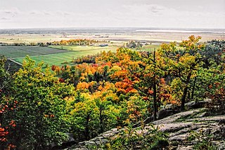
Pontiac is a municipality in the Outaouais Region of western Quebec, Canada, on the north shore of the Ottawa River. It is part of Les Collines-de-l'Outaouais Regional County Municipality, included in the National Capital Region. It should not be confused with Pontiac Regional County Municipality, which is also in the Outaouais but not included in the National Capital Region.

<span class="mw-page-title-main">La Haute-Côte-Nord Regional County Municipality</span> Regional county municipality in Quebec, Canada

La Haute-Côte-Nord is a regional county municipality in northeastern Quebec, Canada, in the Côte-Nord region. It is located on the Gulf of Saint Lawrence where the Saguenay River flows into it. The seat is Les Escoumins. The municipality has a land area of 11,612.68 square kilometres (4,483.68 sq mi) and its population was 10,846 inhabitants as of the 2016 census. Its largest community is the city of Forestville.

<span class="mw-page-title-main">Marguerite-D'Youville Regional County Municipality</span> Regional county municipality in Quebec, Canada

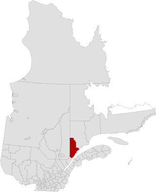
Marguerite-D'Youville is a regional county municipality located in the Montérégie region of southwestern Quebec, Canada. The seat is in Verchères.

<span class="mw-page-title-main">La Vallée-de-la-Gatineau Regional County Municipality</span> Regional county municipality in Quebec, Canada

La Vallée-de-la-Gatineau is a regional county municipality in the Outaouais region of western Quebec, Canada. The seat is in Gracefield. It was incorporated on January 1, 1983 and was named for its location straddling the Gatineau River north of Low.

<span class="mw-page-title-main">Pierre-De Saurel Regional County Municipality</span> Regional county municipality in Quebec, Canada

Pierre-De Saurel is a regional county municipality in the Montérégie region in southwestern Quebec, Canada. Originally named Le Bas-Richelieu Regional County Municipality, the name change to Pierre-De Saurel took effect on January 1, 2009. Its seat is in Sorel-Tracy. It is located on the Richelieu River, downstream from La Vallée-du-Richelieu Regional County Municipality at the confluence of the Richelieu and Saint Lawrence River.

<span class="mw-page-title-main">Le Domaine-du-Roy Regional County Municipality</span> Regional county municipality in Quebec, Canada

Le Domaine-du-Roy(The King's Domain) is a regional county municipality in the Saguenay-Lac-Saint-Jean region of Quebec, Canada. Its seat is in Roberval, and it is named for the King of France, who owned the land at the time of the colonization of Quebec.

<span class="mw-page-title-main">Le Haut-Richelieu Regional County Municipality</span> Regional county municipality in Quebec, Canada

Le Haut-Richelieu Regional County Municipality(Upper Richelieu) is a regional county municipality in the Montérégie region in southwestern Quebec, Canada. Its seat is in Saint-Jean-sur-Richelieu. It is named for the Richelieu River which runs south-north through it.

<span class="mw-page-title-main">Les Basques Regional County Municipality</span> Regional county municipality in Quebec, Canada

Les Basques(the Basques) is a regional county municipality in the Bas-Saint-Laurent region in eastern Quebec, Canada. It is located on the south bank of the Saint Lawrence River halfway between Rimouski and Rivière-du-Loup.

<span class="mw-page-title-main">Les Jardins-de-Napierville Regional County Municipality</span> Regional county municipality in Quebec, Canada

Les Jardins-de-Napierville(English: The Gardens of Napierville) is a regional county municipality (French: Municipalité régionale de comté ) in southwestern Quebec, Canada in the Montérégie region. Founded on January 1, 1982. Its seat is Napierville.

<span class="mw-page-title-main">Les Maskoutains Regional County Municipality</span> Regional county municipality in Quebec, Canada

Les Maskoutains is a regional county municipality in the Montérégie region in southwestern Quebec, Canada. Its seat is in Saint-Hyacinthe.

<span class="mw-page-title-main">Les Pays-d'en-Haut Regional County Municipality</span> Regional county municipality in Quebec, Canada

Les Pays-d'En-Haut is a regional county municipality in the Laurentides region of Quebec, Canada. The population according to the 2016 Canadian Census was 41,877.

<span class="mw-page-title-main">Papineau Regional County Municipality</span> Regional county municipality in Quebec, Canada

Papineau is a regional county municipality in the Outaouais region of Quebec, Canada. The seat is Papineauville.

<span class="mw-page-title-main">Pontiac Regional County Municipality</span> Regional county municipality in Quebec, Canada

Pontiac is a regional county municipality in the Outaouais region of Quebec, Canada. Campbell's Bay is the county seat. It should not be confused with the municipality of Pontiac, which is located in the neighbouring Les Collines-de-l'Outaouais Regional County Municipality. For the electoral district see Pontiac.

<span class="mw-page-title-main">Témiscouata Regional County Municipality</span> Regional county municipality in Quebec, Canada

Témiscouata is a regional county municipality in the Bas-Saint-Laurent region of Quebec, Canada. It is located southeast of Rivière-du-Loup, bordering New Brunswick, and is centred on Lake Témiscouata. Its seat is Témiscouata-sur-le-Lac.

<span class="mw-page-title-main">La Vallée-de-l'Or Regional County Municipality</span> Regional county municipality in Quebec, Canada

La Vallée-de-l'Or is a regional county municipality in the Abitibi-Témiscamingue region in Northwestern Quebec, Canada. The seat is in Val-d'Or. It is named for its gold deposits in the Harricana River and Bell River valleys.

<span class="mw-page-title-main">Chelsea, Quebec</span> Municipality in Quebec, Canada

Chelsea is a municipality located immediately north of Gatineau, Quebec, Canada, and about 10 kilometres (6.2 mi) north of Ottawa. Chelsea is located within Canada's National Capital Region. It is the seat of Les Collines-de-l'Outaouais Regional County Municipality.

<span class="mw-page-title-main">Le Haut-Saint-Laurent Regional County Municipality</span> Regional county municipality in Quebec, Canada

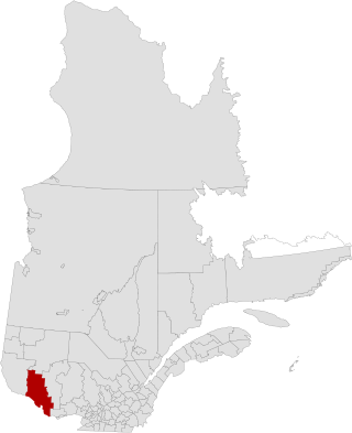
Le Haut-Saint-Laurent(Upper Saint Lawrence) is a regional county municipality in southwestern Quebec, Canada, in the Montérégie region. Its seat is in Huntingdon. It is named for the Saint Lawrence River, which forms its western and its northwestern boundaries.

<span class="mw-page-title-main">Val-des-Monts</span> Municipality in Quebec, Canada

Val-des-Monts is a municipality in the Outaouais region of Quebec, Canada, located about 40 km (25 mi) north of Ottawa, Ontario. It has a population of 13,328 residents in 2021. Formed in 1975 by the merger of the towns of Perkins, Saint-Pierre-de-Wakefield and Poltimore, it consists mainly of farms and mountainous forests. Many of its residents commute to Ottawa or Gatineau for work. Due to its numerous lakes, its population is boosted during summers by people living in cottages. Most of the people in Val-des-Monts live in the village of Perkins.

<span class="mw-page-title-main">La Pêche</span> Municipality in Quebec, Canada

La Pêche is a municipality along both sides of the Gatineau River in Les Collines-de-l'Outaouais Regional County Municipality in the Outaouais region of Quebec, Canada, about 30 km (19 mi) north of downtown Gatineau.

<span class="mw-page-title-main">L'Ange-Gardien, Outaouais, Quebec</span> Municipality in Quebec, Canada

L'Ange-Gardien is a municipality in the Outaouais region of Quebec, Canada. It constitutes the easternmost part of Les Collines-de-l'Outaouais Regional County Municipality, north of the Buckingham Sector of the City of Gatineau.

References

  1. "Reference number 269051 in Banque de noms de lieux du Québec". toponymie.gouv.qc.ca (in French). Commission de toponymie du Québec.
  2. 1 2 3 "Geographic code 820 in the official Répertoire des municipalités". www.mamh.gouv.qc.ca (in French). Ministère des Affaires municipales et de l'Habitation.
  3. 1 2 3 "Census Profile, 2021 Census: Les Collines-de-l'Outaouais, Municipalité régionale de comté [Census division], Quebec - Notre-Dame-de-la-Salette, Municipalité (MÉ) [Census subdivision], Quebec". Statistics Canada. Retrieved May 16, 2023.
  4. 1 2 "2021 Community Profiles". 2021 Canadian Census . Statistics Canada. February 4, 2022. Retrieved 2023-10-19.
  5. "2016 Community Profiles". 2016 Canadian Census . Statistics Canada. August 12, 2021. Retrieved 2019-12-20.
  6. "2011 Community Profiles". 2011 Canadian Census . Statistics Canada. March 21, 2019. Retrieved 2019-12-20.
  7. "2006 Community Profiles". 2006 Canadian Census . Statistics Canada. August 20, 2019.
  8. "2001 Community Profiles". 2001 Canadian Census . Statistics Canada. July 18, 2021.
  9. Official Transport Quebec Road Map