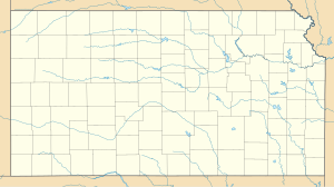
The first tangible move to implement the decision to locate an Army Air Corps four-engine pilot school on a site selected one mile west of Liberal in western Kansas, was the grant of a contract to Murray A. Wilson and Company, engineers, to make a complete survey and layout for an airfield. The new airfield was situated in Sections 1, 6, 25, 30, 31, and 36, Townships 34 and 35 South, and Ranges 33 and 34 West, with a dimension of two miles north and south and two miles east and west. The field formed part of a flat, low plateau.
By 16 January 1943 the survey had been completed. But even before the survey had been officially finished, contracts were let on 9 January, with Peter Kiewit Sons named as prime contractor. The entire field, some 1,946.7 acres, was purchased by the government. In addition, 3.3 acres on the north extremity of the north-south runway were leased to provide zone clearance space. Just nine days later construction began on the site.
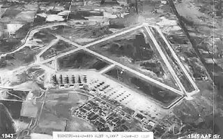
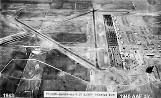
Facilities on Liberal Army Airfield were to cost approximately $8,000,000. Initially three concrete runways were built, each 7,000 feet in length and 150 feet wide, with a gross load capacity of 37,000 pounds. Portable B-2 type runway lights were installed. In addition, a concrete parking apron of some 276,318 square yards was constructed, along with three concrete taxiways 100 feet in width. In 1943, a second set of three runways, identical and parallel to the first three were built. An enclosing loop taxiway was also constructed. This doubled the capacity of the airfield for landings and takeoffs.
Training facilities included three school buildings and four buildings housing Link Trainers. Five hangars were built, two of steel and three of wood. Three large warehouses and storage facilities for 591,000 gallons of gasoline were built. Construction coming under the general category of recreation and welfare included a gymnasium, officers' club, service club, theater, chapel, and three post exchanges. A spur line of the Rock Island Railroad was run onto the field from the main line. Housing facilities for 4,934 officers and men and a hospital with a normal bed capacity of 142 were constructed. All buildings were of mobilization type construction.
In addition to the main installation, Gage Auxiliary Field, 36°17′43″N099°46′35″W / 36.29528°N 99.77639°W / 36.29528; -99.77639 (Gage AAAF) a former municipal airport, was acquired by lease. This field, some 81 miles from Liberal Army Air Field, comprised 780 acres providing two hard surfaced runways, each of which was 5,500 feet in length and 150 feet wide.
B-24 Liberator Basic Training School
In April 1943, before completion of construction, the initial group of officers and men of the original cadre reported. Liberal AAF was officially opened on 13 May 1943. It placed was under the jurisdiction of the Army Air Forces Pilot School (Specialized 4-Engines), II Bomber Command, Second Air Force. The mission of the base was to train Consolidated B-24 Liberator heavy bomber pilots, who were predominantly newly commissioned officers graduated from Training Command advanced twin-engine flying schools.
Additional personnel arrived during subsequent weeks. In the midst of construction, personnel acquisition moved into an intensified phase during April and May, so that the base was actively manned by the time the first B-24s to be used in training set down on the brand new runways on 20 June. That scheduling was extremely close during those hectic days can be seen in that only ten days later, on 1 July, the members of the first class were introduced to the Liberators. This is the official date of the inauguration of training at Liberal, barely six months after construction began. Initially and for a considerable time the commanding officer of the field was in charge of the several squadrons and detachments which performed the various functions requisite to the functioning of the school.
The training cycle was nine weeks in length. Halfway through the cycle of the first class, another class began the course, so that, afterward, a class graduated every four and a half weeks. By 8 December 1943 Col. R. C. Rockwood, operations and training officer, was able to tell a group of civilian employees that "we are now training approximately one-fourth of the Liberator bomber commanders trained in the continental United States". The pace of training is well illustrated in that it was not until 7 October 1943 that time was found for a formal dedication.
George McGovern, later a senator and candidate for President of the United States, trained as a B-24 pilot at Liberal.[1]
On 1 May 1944 all the separate units on the field were disbanded except for the 744th AAF Band, the Airways Communications Squadron, and the Base Weather Section. In place of the disbanded organizations the several sections of the 2525th Base Unit were created, distinguished by the nature of the service performed:
Unit Headquarters.
Section "A" administration and services.
Section "B" training and operations.
Section "C" supply and maintenance.
Section "E" medical.
Section "F" Black personnel.
Section "H" officer students.
In February 1945 these sections were redesignated squadrons, which remained in existence until inactivation of the field. After victory in Europe the training program of Liberal Army Airfield became somewhat erratic because of the frequent changes of policy in the Training Command. However, with the surrender of the Japanese in August, the mission of the school was definitely over.
Inactivation
On 7 September 1945 the commanding officer received official orders for inactivation of the field on or before 30 September. B-24 Liberators were obsolete as the postwar Air Force would retain the Boeing B-29 Superfortress as its long-range strategic bomber. Liberal field was placed at that time on a standby status, which meant maintaining it in such condition as would make possible reactivation within thirty days. Consequently, the field's activities for the greater part of September were largely concerned with the process of inactivation. On 19 September the officer students were slated to complete training at Hondo Army Air Field where the 2523d Army Air Forces Base Unit would complete the four-engine training on B-24s transferred from Liberal.
All remaining personnel, except officers and enlisted men scheduled to form the standby cadre, were put on movement orders on 29 September. Although the majority of departments were still functioning on 1 October, they were prepared to close down within a few days. Four days later, Liberal Army Airfield was turned over to the Army's District Engineer, Seventh Service Command at Omaha, Nebraska who assumed jurisdiction over the field, pending disposition. Excess buildings and demilitarized equipment were sold or transferred to other bases. Some were torn down and sales were held for scrap lumber of torn down buildings, fence posts, barbed wire and other surplus items.
During its 27 months of actual training, Liberal Army Air Field graduated 4,468 four-engine airplane commanders. In addition, 1,025 pilots were graduated from the pre-transition course conducted for a period in the middle of 1944.
Current status
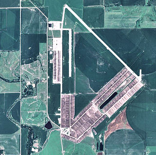
2006 USGS airphoto of the former Liberal Army Airfield
Since the end of World War II, the installation has been operated by the city of Liberal as its municipal airport. One of the runways is maintained for use primarily by general aviation, although limited commercial airline service is offered. The large airfield remains intact, with a few sections of concrete removed to limit access. The large parking apron remains, part of it used by the Mid-America Air Museum. The base station has been totally redeveloped into a light industrial park, university campus and recreation fields. Many streets remain along with the outline of the base parade ground and headquarters.
Bruning Army Air Field was a flight training installation of the United States Army Air Forces used during World War II and located in northeast Thayer County, Nebraska, at coordinates 40°20'25" North, 97°25'42" West, approximately six miles east of Bruning.
Fairmont State Airfield is three miles south of Fairmont, in Fillmore County, Nebraska. The National Plan of Integrated Airport Systems for 2011–2015 categorized it as a general aviation facility. It has no scheduled airline service.
Scribner State Airport is three miles southeast of Scribner, in Dodge County, Nebraska.
Dyersburg Army Air Base is an inactive United States Air Force base, approximately 2 miles north of Halls, Tennessee. It was active during World War II as a training airfield. It was closed on 30 November 1945
Pratt Army Airfield is a closed United States Army Air Forces base. It is located 4 miles (6.4 km) north-northwest of Pratt, Kansas, and was closed in 1946. Today it is used as Pratt Regional Airport.
Walker Army Airfield is an abandoned airfield located north of Interstate 70 in Ellis County, 1 mile northwest of Walker, Kansas or 3 miles northeast of Victoria, Kansas.
Dodge City Army Airfield, also known as Ford County Airport and Dodge City Municipal Airport, is an abandoned airfield located in Ford County, Kansas, 6 miles (9.7 km) northwest of Dodge City.
Dateland Air Force Auxiliary Field is an abandoned military airfield located in Dateland, Arizona, 40 miles (64 km) east of Yuma, Arizona. Its last known military use was in 1957.
Columbia Army Air Base was a World War II United States Army Air Forces base. It was primarily used for advanced combat training of B-25 Mitchell medium bomber units and replacement pilots.
Dalhart Army Air Base is a former World War II military airfield complex near the city of Dalhart, Texas. It operated three training sites for the United States Army Air Forces from 1943 until 1945.
Garden City Army Airfield was a World War II training base of the United States Army Air Forces Central Flying Training Command (CFTC). It is currently the city-owned Garden City Regional Airport.
Strother Army Airfield was a World War II training base of the United States Army Air Forces Central Flying Training Command (CFTC), and later II Fighter Command. It is currently the city-owned Strother Field.
Lowcountry Regional Airport is a public use airport located two nautical miles (4 km) northeast of the central business district of Walterboro, a city in Colleton County, South Carolina, United States. It is owned by the city and county. This airport is included in the National Plan of Integrated Airport Systems for 2011–2015, which categorized it as a general aviation facility. It does not have scheduled commercial airline service.
Beauregard Regional Airport is a public use airport in Beauregard Parish, Louisiana, United States. It is owned by Beauregard Parish and is located three nautical miles (6 km) southwest of the central business district of DeRidder, Louisiana. The airport serves the general aviation community, with no scheduled commercial airline service.
Hendricks Army Airfield was a World War II United States Army Air Forces base located 6.6 miles east-southeast of Sebring, Florida.
San Angelo Army Airfield is an inactive United States Air Force base, about 8 miles south-southwest of San Angelo, Texas. It was active during World War II as a training airfield. It was closed on 30 November 1945.
Independence Army Airfield was a World War II training base of the United States Army Air Forces Central Flying Training Command (CFTC). It is currently the city-owned Independence Municipal Airport.
Freeman Army Airfield is an inactive United States Army Air Forces base. It is located 2.6 miles (4.2 km) south-southwest of Seymour, Indiana.
Fort Wayne Air National Guard Base is a United States Air Force base, located at Fort Wayne International Airport, Indiana. It is located 7.6 miles (12.2 km) south-southwest of Fort Wayne, Indiana.
Page Field Army Airfield is an inactive United States Army Air Forces base, approximately 4 miles south of Fort Myers, Florida. It was active during World War II as a Third Air Force training airfield. It was closed on 30 September 1945, two years prior to the establishment of the United States Air Force as an independent service.
Shaw, Frederick J. (2004), Locating Air Force Base Sites History’s Legacy, Air Force History and Museums Program, United States Air Force, Washington DC, 2004.
This page is based on this Wikipedia article Text is available under the CC BY-SA 4.0 license; additional terms may apply. Images, videos and audio are available under their respective licenses.