
Ely Airport is a county-owned airport three miles northeast of Ely, in White Pine County, Nevada, United States.
Cortez Municipal Airport is three miles southwest of Cortez, in Montezuma County, Colorado, United States. It has passenger service from one airline: Key Lime Air DBA Denver Air Connection.

Laramie Regional Airport is three miles west of Laramie, in Albany County, Wyoming. It is owned by the Laramie Regional Airport Board. Airline service is subsidized by the Essential Air Service program.

Kearney Regional Airport is an airport five miles northeast of Kearney in Buffalo County, Nebraska. Denver Air Connection provides scheduled passenger service to Denver which is supported by the Essential Air Service.

North Platte Regional Airport is a public airport three miles east of North Platte, in Lincoln County, Nebraska. It is owned by the North Platte Airport Authority and sees one airline, subsidized by the Essential Air Service program.
Grant County Airport is a county-owned, public-use airport in Grant County, New Mexico, United States. It is located 10 nautical miles southeast of the central business district of Silver City, New Mexico. The airport is mostly used for general aviation, but is also served by one commercial airline. Service is subsidized by the Essential Air Service program.
Clovis Regional Airport is a city-owned, public-use airport located six nautical miles east of the central business district of Clovis, a city in Curry County, New Mexico, United States. The facility opened in April, 1959 and is mostly used for general aviation, but is also served by one commercial airline. Current scheduled passenger service is subsidized by the Essential Air Service program. The airport was previously known as Clovis Municipal Airport but underwent a name change to Clovis Regional Airport in 2021 when it was upgraded to Part 121 status.

San Luis Valley Regional Airport is two miles south of Alamosa, in Alamosa County, Colorado, United States. It sees one airline, subsidized by the Essential Air Service program. The airport reached 10,000 enplanements for the first time in its EAS participation with Boutique Air and is now classified as a non-hub primary airport.

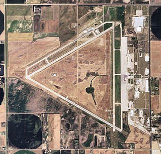
Dodge City Regional Airport is three miles east of Dodge City, in Ford County, Kansas. It is used for general aviation and is subsidized by the Essential Air Service program.
Great Bend Municipal Airport is five miles west of Great Bend, in Barton County, Kansas. It is used for general aviation and formerly saw one airline, subsidized by the Essential Air Service program.
Hays Regional Airport is three miles southeast of Hays, in Ellis County, Kansas, United States. It is used for general aviation and sees one airline, United Express.

Altoona–Blair County Airport is in Martinsburg, Pennsylvania, 14 miles south of Altoona, in Blair County, Pennsylvania. It is owned by the Blair County Airport Authority. The airport has a few airline flights, subsidized by the Essential Air Service program.

Watertown International Airport is in the Town of Hounsfield in Jefferson County, New York, United States, 6 mi west of Watertown. The airport is used for general aviation, but has scheduled passenger service subsidized by the Essential Air Service program. The airport has no scheduled international passenger flights, but is available as an international port of entry for private aircraft on two hours' advance notice from pilots.

John Murtha Johnstown–Cambria County Airport is a civil-military airport three miles (5 km) northeast of Johnstown, in Cambria County, Pennsylvania. It is owned by Johnstown–Cambria County Airport Authority and is named after the late Congressman John Murtha. It sees one airline, subsidized by the Essential Air Service.
Dawson Community Airport is five miles northwest of Glendive, in Dawson County, Montana, United States. The airport has one airline, subsidized by the Essential Air Service program.
Miles City Airport or Frank Wiley Field is a city-owned airport two miles northwest of Miles City, in Custer County, Montana, United States. The airport was served by one airline, subsidized by the Essential Air Service program. EAS subsidies ended on July 15, 2013, due to subsidy per passenger exceeding $1000, leaving Miles City without scheduled air service.
L. M. Clayton Airport is a public airport three miles east of Wolf Point, in Roosevelt County, Montana, United States. The airport is served by one airline, subsidized by the Essential Air Service program. Reportedly, it is the smallest airport in the 48 contiguous states with scheduled air service.
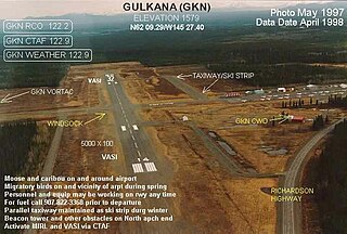
Gulkana Airport is a state owned, public use airport located four nautical miles northeast of the central business district of Gulkana, in the Valdez-Cordova Census Area of the U.S. state of Alaska. It is also and five miles (8 km) northeast of Glenallen. Scheduled passenger service is subsidized by the Essential Air Service program.
Excursion Inlet Seaplane Base is a state owned, public use seaplane base located in Excursion Inlet, in the Haines Borough of the U.S. state of Alaska. Scheduled passenger service is subsidized by the U.S. Department of Transportation via the Essential Air Service program.
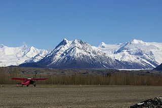
McCarthy Airport is a state owned, public use airport located one nautical mile (2 km) northeast of the central business district of McCarthy, in the Valdez-Cordova Census Area of the U.S. state of Alaska. Scheduled passenger service is subsidized by the Essential Air Service program.


