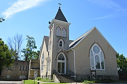
Liberty is an unincorporated community in Montgomery County, in the U.S. state of Ohio. [1]
Liberty was platted in 1815. [2] A post office called Liberty was established in 1814, and remained in operation until 1914. [3]
The Miami Valley is the land area surrounding the Great Miami River in southwest Ohio, USA, and includes the Little Miami, Mad, and Stillwater rivers as well. Geographically, it includes Dayton, Springfield, Middletown, Hamilton, and other communities. The name is derived from the Miami Indians.
Chautauqua , also Chautaugua or Chatauqua, is an unincorporated community in Montgomery and Warren counties in the U.S. state of Ohio. Chautauqua is located at 39°35′28″N84°17′47″W. It lies on the west bank of the Great Miami River at the county boundary. It was established in 1901 with 310 acres (1.3 km2). The members of the Miami Valley Chautauqua Association lived in common in the town, occupying about two hundred homes.
Bethany is an unincorporated community in southeastern Liberty Township, Butler County, Ohio, United States, located in the southwestern part of Ohio. It lies about three miles south of Monroe.
Alert is an unincorporated community in southern Morgan Township, Butler County, Ohio, in the United States. It is located about ten miles southwest of Hamilton on Howards Creek, a tributary of the Great Miami River in section 28 of R1ET3N of the Congress Lands. It is three miles west of Shandon and two miles south of Okeana.
New Marshfield is a census-designated place in central Waterloo Township, Athens County, Ohio, United States. As of the 2010 census it had a population of 326. It has a post office with the ZIP code 45766. It is located along State Route 56 west of the county seat of Athens.
Wolf Creek is a 19.8-mile-long (31.9 km) tributary of the Great Miami River in southwestern Ohio in the United States. It rises in western Montgomery County, northwest of Brookville, and flows generally southeast, passing through the center of Trotwood and joining the Great Miami in downtown Dayton.
Little York is an unincorporated community in Butler Township, Montgomery County, Ohio, United States. It is located on the east bank of the Stillwater River, at the intersection of Little York Road and Meeker Road, not far from the intersection of I-70 and Ohio State Route 48.
Sixteen Mile Stand is a census-designated place (CDP) in Symmes Township, Hamilton County, Ohio, United States, 19 miles (31 km) northeast of downtown Cincinnati. The population of Sixteen Mile Stand was 2,928 at the 2010 census.
Dyes Fork is a stream in the U.S. state of Ohio.
Snow Hill is an unincorporated community in Clinton County, in the U.S. state of Ohio.
Ludlow Creek is a stream in the U.S. state of Ohio. The 13.5-mile (21.7 km) long stream is a tributary of the Stillwater River.
Airhill is an unincorporated community in Montgomery County, in the U.S. state of Ohio.
Amity is an unincorporated community in Montgomery County, in the U.S. state of Ohio.
Bachman is an unincorporated community in Montgomery County, in the U.S. state of Ohio.
Dodson is an unincorporated community in Montgomery County, in the U.S. state of Ohio.
Fishburg is an extinct town in Montgomery County, in the U.S. state of Ohio. The exact location of the town is unknown to the GNIS.
Kinsey is a historic community in Montgomery County, in the U.S. state of Ohio; its location, 39°51′14″N84°17′34″W, makes it a neighborhood of Englewood.
Spanker is an unincorporated community in Montgomery County, in the U.S. state of Ohio.
Tadmor is an extinct town in Montgomery County, in the U.S. state of Ohio. Its location, 39°53′45″N84°9′55″W, is now within the Vandalia city limits.
Arlington is an unincorporated community in Montgomery County, in the U.S. state of Ohio.