Liberty Avenue (Pittsburgh)

Last updated
Liberty Avenue
20140523 04 Liberty Ave. near 10th Ave (16017931864).jpg
Liberty Avenue near 10th Avenue with Union Station visible in the background
Length4.3 mi (6.9 km)
Location Pittsburgh
West endI-376.svgUS 22.svgUS 30.svg I-376  / US 22  / US 30 in Downtown
Major
junctions
Stanwix Street in Downtown
Penn Avenue in Downtown
Fifth Avenue in Downtown
Grant Street in Downtown
PA-380.svg PA 380 (Baum Blvd) in Bloomfield
East endAiken Avenue in Shadyside

Liberty Avenue is a major thoroughfare starting in downtown Pittsburgh, Pennsylvania, United States, just outside Point State Park. Liberty Avenue runs through Downtown Pittsburgh, the Strip District, and Bloomfield and ends in the neighborhood of Shadyside at its intersection with Centre Avenue and Aiken Avenue. Liberty Avenue is about 4.3 miles (6.9 km) long.

Contents

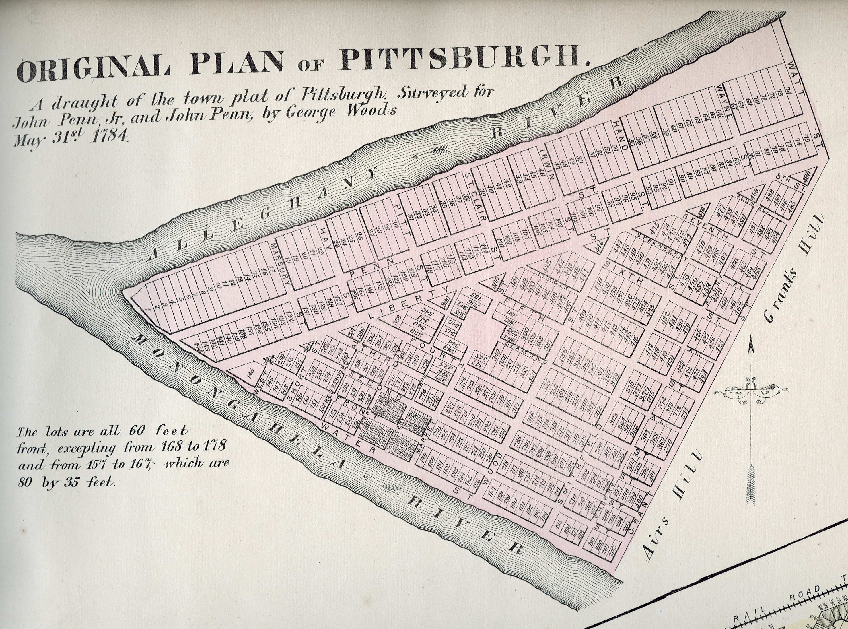
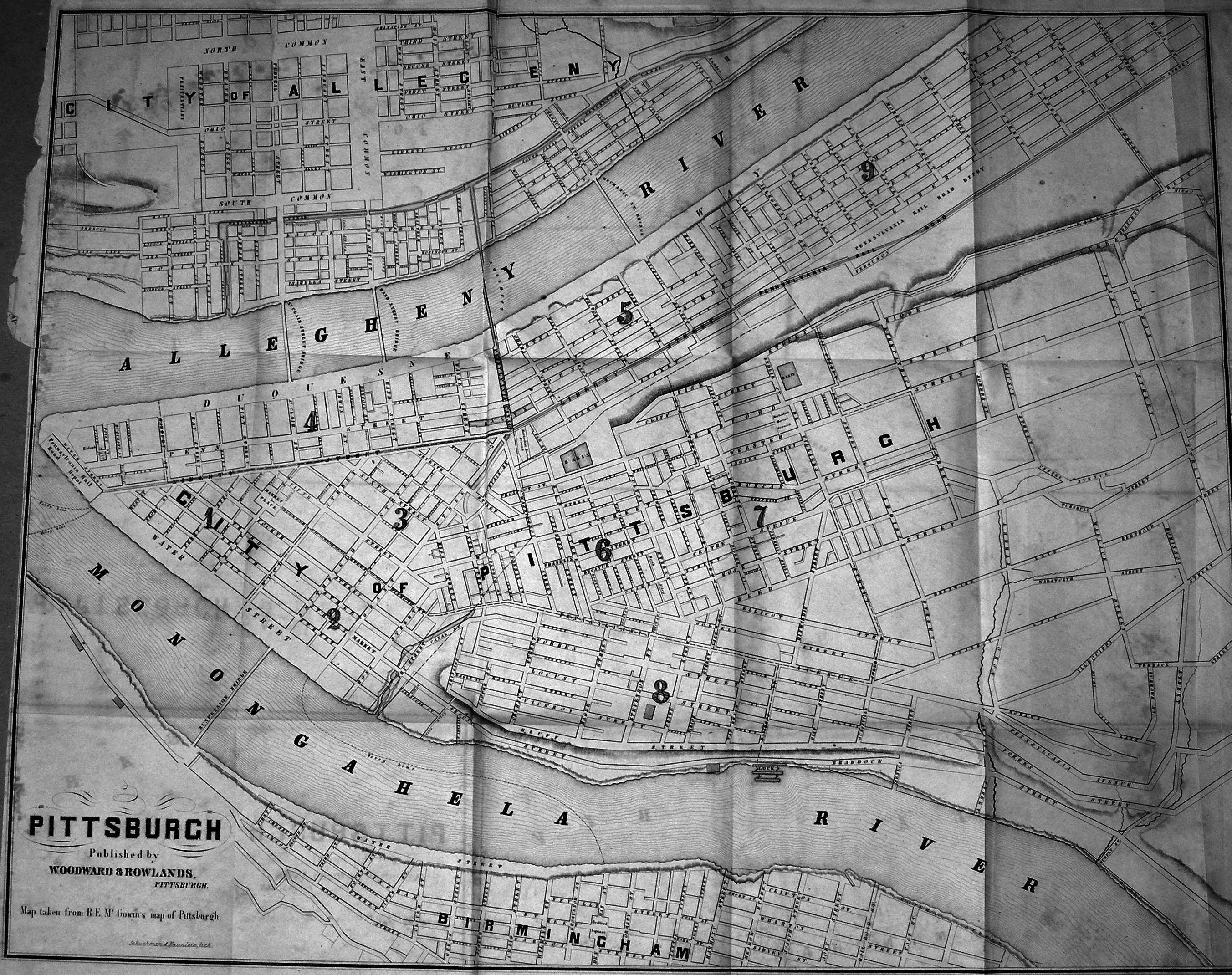
A survey of Pittsburgh in 1784 already shows a Liberty Street in its present location. [1] It is also called Liberty Street in a map from 1860. [2]

Downtown

Buildings along Liberty Avenue Liberty Avenue in the Penn-Liberty Historic District.jpg
Buildings along Liberty Avenue

Beginning in the 19th century, the thoroughfare became a place of middle- and upper-class commerce. A history of Pittsburgh notes that a Market House was established in 1832 along Liberty Street between Sixth Street and Cecil Alley. [3] Liberty also hosted food suppliers, brewers, and small manufacturers. In 1894, the Joseph Horne department store was built there. In the early 20th century, the Clark Building (named for the Clark candy company) and the Second National Bank were built. At length, it became a home for theater and movies, with the Stanley Theatre, the Lowe's Penn and the Harris Theatre. However, much of this activity was checked, first by the Great Depression, and then by the St. Patrick's Day Flood of 1936. Some businesses were closed, and others moved elsewhere. [4]

A section of Liberty Avenue in Downtown Pittsburgh became a red-light district in the 1970s and 1980s, hosting the city's sex industry, including burlesque houses, strip bars, and peep shows, and attracting vice and crime. [5] The Pittsburgh Cultural Trust, formed in 1984, worked over the next 25 years to transform the area into the Cultural District, a center for the arts, eventually bringing the August Wilson Center for African American Culture, Bricolage Production Company, [6] Pittsburgh Playwrights Theatre Company, [7] the Pittsburgh Cultural Trust Arts Education Center, and a museum of cartoon art, The ToonSeum, to Liberty Avenue. [8]

Liberty Avenue in the downtown area underwent a years-long extensive $3.6 million redesign and repavement that was completed by 1991. [9]

Strip District

Liberty Avenue is a main road through the Strip District. It is the home to many businesses, mostly offices and business-to-business service and product providers. The factory to manufacture George Westinghouse's air brakes was located at 2425 Liberty. This has now become the home of the Pittsburgh Opera. There are few retail establishments on Liberty Avenue in the Strip District.

Bloomfield

Liberty Avenue is the site of the main business district in Bloomfield. Liberty Avenue is also home to West Penn Hospital as well as many small store fronts.

A semi-fictionalized version of Liberty Avenue is featured prominently in the American version of the television program Queer as Folk .

Major junctions

The entire route is in Pittsburgh, Allegheny County.

mikmDestinationsNotes
West plate blue.svg
I-376.svg
Airport Sign.svg I-376 west / US 22 west / US 30 west (Penn Lincoln Parkway) Carnegie, Pittsburgh International Airport
To plate blue.svg
East plate blue.svg
I-376.svg
To plate blue.svg
North plate blue.svg
I-279.svg
Commonwealth Place to I-376 east / US 22 east / US 30 east (Penn Lincoln Parkway) / I-279 north
Western terminus of Liberty Avenue
Penn Avenue Westbound entrance only
Pittsburgh PA Purple Belt shield.svg Purple Belt (Stanwix Street)
Fifth Avenue
Pittsburgh PA Purple Belt shield.svg Purple Belt (Grant Street) PPG Paints Arena
East Busway
Western terminus of concurrency with Purple Belt
Pittsburgh PA Purple Belt shield.svg Purple Belt (11th Street)Eastern terminus of concurrency with Purple Belt
To plate blue.svg
I-279.svg
15th Street to I-279
26th Street - East Busway
To plate.svg
PA-380.svg
Bloomfield Bridge  / Main Street to PA 380 (Bigelow Boulevard)
PA-380.svg PA 380 (Baum Boulevard) / Aiken AvenueEastern terminus of Liberty Avenue
1.000 mi = 1.609 km; 1.000 km = 0.621 mi

Related Research Articles

<span class="mw-page-title-main">Oakland (Pittsburgh)</span> Place in Pennsylvania, United States

Oakland is the academic and healthcare center of Pittsburgh and one of the city's major cultural centers. Home to three universities, museums, hospitals, shopping venues, restaurants, and recreational activities, this section of the city also includes two city-designated historic districts: the mostly residential Schenley Farms Historic District and the predominantly institutional Oakland Civic Center Historic District, as well as the locally-designated Oakland Square Historic District.

<span class="mw-page-title-main">Downtown Pittsburgh</span> Neighborhood in Allegheny County, Pennsylvania, United States

Downtown Pittsburgh, colloquially referred to as the Golden Triangle, and officially the Central Business District, is the urban downtown center of Pittsburgh, Pennsylvania, United States. It is located at the confluence of the Allegheny River and the Monongahela River whose joining forms the Ohio River. The triangle is bounded by the two rivers.

<span class="mw-page-title-main">Bloomfield (Pittsburgh)</span> Neighborhood of Pittsburgh in Allegheny County, Pennsylvania, United States

Bloomfield is a neighborhood in Pittsburgh, Pennsylvania. It is located three miles from the downtown area. Bloomfield is sometimes referred to as Pittsburgh's Little Italy because it was settled by Italians from the Abruzzi region and has been a center of Italian–American population. Pittsburgh architectural historian Franklin Toker has said that Bloomfield "is a feast, as rich to the eyes as the homemade tortellini and cannoli in its shop windows are to the stomach." Recently, the neighborhood has attracted young adults and college students as a "hip" neighborhood.

<span class="mw-page-title-main">Friendship (Pittsburgh)</span> Neighborhood of Pittsburgh in Allegheny County, Pennsylvania, United States

Friendship is a neighborhood of large Victorian houses in the East End of the City of Pittsburgh, Pennsylvania, United States, about four miles (6 km) east of Pittsburgh's Golden Triangle. Friendship is bordered on the north by Garfield, on the east by East Liberty, on the south by Shadyside, and on the west by Bloomfield. It is divided into three Pittsburgh City Council districts.

<span class="mw-page-title-main">Highland Park (Pittsburgh neighborhood)</span> Neighborhood of Pittsburgh in Allegheny County, Pennsylvania, United States

Highland Park is a neighborhood in the northeastern part of Pittsburgh, Pennsylvania. Highland Park, the neighborhood, fully encompasses the park with the same name.

<span class="mw-page-title-main">East Liberty (Pittsburgh)</span> Neighborhood of Pittsburgh in Allegheny County, Pennsylvania, United States

East Liberty is a neighborhood in Pittsburgh, Pennsylvania's East End. It is bordered by Highland Park, Morningside, Stanton Heights, Garfield, Friendship, Shadyside and Larimer, and falls largely within Pittsburgh City Council District 9, with a few areas in District 8. One of the most notable features in the East Liberty skyline is the East Liberty Presbyterian Church, which is an area landmark.

<span class="mw-page-title-main">Garfield (Pittsburgh)</span> Place in Pennsylvania, United States

Garfield is a neighborhood in the East End of the City of Pittsburgh, Pennsylvania, United States. Garfield is bordered on the South by Bloomfield and Friendship, on the West by the Allegheny Cemetery, on the North by Stanton Heights, and on the East by East Liberty. Like many parts of Pittsburgh, Garfield is a fairly steep neighborhood, with north-south residential streets running at about a 20% incline from Penn Avenue at the bottom to Mossfield Street at the top. Garfield is divided into “the valley” and “the hilltop.”

<span class="mw-page-title-main">Strip District, Pittsburgh</span> Neighborhood in Allegheny County, Pennsylvania, United States

The Strip District is a neighborhood in Pittsburgh, Pennsylvania, United States. It is a one-half square mile area of land northeast of the central business district bordered to the north by the Allegheny River and to the south by portions of the Hill District. The Strip District runs between 11th and 33rd Streets and includes four main thoroughfares—Railroad Street/Waterfront Place, Smallman Street, Penn Avenue, and Liberty Avenue—as well as various side streets.

<span class="mw-page-title-main">Avenue of the Arts (Philadelphia)</span> Neighborhood of Philadelphia in Pennsylvania, United States

Avenue of the Arts is a city-designated arts cultural district on a segment of Broad Street in Philadelphia, Pennsylvania, United States that includes many of the city's cultural institutions, most notably the theater district south of City Hall. The designation can be found as far south as Washington Avenue and as far north as the Cecil B. Moore neighborhood.

<span class="mw-page-title-main">Lawrenceville (Pittsburgh)</span> Place in Pennsylvania, United States

Lawrenceville is one of the largest neighborhood areas in Pittsburgh in the U.S. state of Pennsylvania. It is located northeast of downtown, and like many of the city's riverfront neighborhoods, it has an industrial past. The city officially divides Lawrenceville into three neighborhoods, Upper Lawrenceville, Central Lawrenceville, and Lower Lawrenceville, but these distinctions have little practical effect. Accordingly, Lawrenceville is almost universally treated as a single large neighborhood.

The culture of Pittsburgh stems from the city's long history as a center for cultural philanthropy, as well as its rich ethnic traditions. In the 19th and 20th centuries, wealthy businessmen such as Andrew Carnegie, Henry J. Heinz, Henry Clay Frick, and nonprofit organizations such as the Carnegie Foundation donated millions of dollars to create educational and cultural institutions.

<span class="mw-page-title-main">Transportation in Pittsburgh</span> Transportation in Pittsburgh, Pennsylvania, United States

A large metropolitan area that is surrounded by rivers and hills, Pittsburgh has an infrastructure system that has been built out over the years to include roads, tunnels, bridges, railroads, inclines, bike paths, and stairways; however, the hills and rivers still form many barriers to transportation within the city.

<span class="mw-page-title-main">Pittsburgh Cultural Trust</span>

The Pittsburgh Cultural Trust (PCT) is an American, nonprofit, arts organization that was formed in 1984 to promote economic and cultural development in Downtown Pittsburgh, Pennsylvania. The "Trust" has focused its work on a fourteen-square block section known as the Cultural District, which encompasses numerous entertainment and cultural venues, restaurants, and residential buildings.

The Cultural District is a fourteen-square-block area in Downtown Pittsburgh bordered by the Allegheny River on the north, Tenth Street on the east, Stanwix Street on the west, and Liberty Avenue on the south.

<span class="mw-page-title-main">Harris Theater (Pittsburgh)</span> Movie theater in Pittsburgh, Pennsylvania, United States

The Harris Theater is a landmark building which is located at 809 Liberty Avenue in Downtown Pittsburgh, Pennsylvania's Cultural District. The 200-seat theater is owned and operated by the Pittsburgh Cultural Trust.

<span class="mw-page-title-main">Pennsylvania Route 380</span> State highway in Pennsylvania, US

Pennsylvania Route 380, also known as J.F. Bonetto Memorial Highway and within the city of Pittsburgh Bigelow Boulevard, Baum Boulevard and Frankstown Road, is a 32.80-mile-long (52.8 km) state highway in western portions of the U.S. state of Pennsylvania. The western terminus of the route is at Interstate 579 in downtown Pittsburgh near PPG Paints Arena. The eastern terminus is at Pennsylvania Route 286 in Bell Township, near the hamlet of Wakena.

<span class="mw-page-title-main">Penn Avenue</span> Major arterial street in Pittsburgh and Wilkinsburg in Pennsylvania

Penn Avenue is a major arterial street in Pittsburgh and Wilkinsburg, in Pennsylvania. Its western terminus lies at Gateway Center in downtown Pittsburgh. For its westernmost ten blocks it serves as the core of the Cultural District with such attractions as Heinz Hall, the Benedum Center and the Byham Theater as well as the David L. Lawrence Convention Center and the Heinz History Center bordering it. Exiting downtown it is the major route through the city's Strip District, Lawrenceville, Bloomfield, Garfield and East Liberty neighborhoods. Its eastern portion exits the city at Wilkinsburg where it continues to exist as Penn Avenue with a numbering system that begins anew using small numbers as it approaches Interstate 376 the "Parkway East". Penn Avenue is about 8.7 miles (14.0 km) long.

<span class="mw-page-title-main">Greensburg Downtown Historic District (Greensburg, Pennsylvania)</span> Historic district in Pennsylvania, United States

The Greensburg Downtown Historic District of Greensburg, Pennsylvania, is bounded approximately by Tunnel Street, Main Street, Third Street, and Harrison Avenue. It consists of 62 buildings on 21.8 acres (8.8 ha), with the most notable buildings from the years 1872-1930. The district's oldest structure (1872) is the former Masonic Temple at 132 South Main Street. The Academy Hill Historic District is directly to the north of downtown Greensburg.

<span class="mw-page-title-main">ToonSeum</span>

The ToonSeum: Pittsburgh Museum of Cartoon Art was a museum devoted exclusively to the cartoon arts that was located in Pittsburgh, Pennsylvania. At the time of its operation it was one of three museums dedicated to cartoon art in the United States.

References

  1. "Original Plan Of Pittsburgh". 1874 via www.mapsofpa.com.
  2. "Map of Pittsburgh". 1860 via www.mapsofpa.com.
  3. Fleming, George Thornton (1922). History of Pittsburgh and Environs, from Prehistoric Days to the Beginning of the American Revolution. Vol. 2. Pittsburgh: American Historical Society. pp. 73–74. Retrieved 2016-08-13.
  4. "Pittsburgh's Liberty Avenue". May 1, 2013.
  5. Seate, Mike (May 12, 2005). "Locals reminisce over red light district's past". Tribune-Review . Retrieved December 11, 2010.[ permanent dead link ]
  6. "Midnight Radio's Pittsburgh Ghost Stories". Pittsburgh City Paper.
  7. "Pittsburgh Playwrights' Theatre Festival in Black & White". Pittsburgh City Paper.
  8. Machosky, Michael (December 25, 2009). "First Night celebrates more than New Year". Tribune-Review. Retrieved December 11, 2010.[ permanent dead link ]
  9. "A grand occasion". The Pittsburgh Press via Google News Archive Search.

40°27′19″N79°58′34″W / 40.45537°N 79.97617°W / 40.45537; -79.97617