Line 2 (Madrid Metro)

Last updated
Madrid-MetroLinea2.svg Line 2
MetroMadridLogo.svg
Estacion de metro de Alsacia (2).jpg
Line 2 train in Alsacia station
Overview
Native nameLínea 2
Owner CRTM
Locale Madrid
Termini
Stations20
Website www.metromadrid.es/en/linea/linea-2
Service
Type Rapid transit
System Madrid Metro
Operator(s) CRTM
Rolling stock CAF 3000
History
Opened11 June 1924;99 years ago (1924-06-11)
Technical
Line length14.031 km (8.718 mi)
CharacterUnderground
Track gauge 1,445 mm (4 ft 8+78 in)
Route map

Contents

BSicon utCONTg.svg
BSicon utCONTgq.svg
BSicon utKBHFa-L.svg
BSicon lACC-L.svg
BSicon utSTRq.svg
BSicon utBHF-R.svg
BSicon lACC-R.svg
BSicon utSTRq.svg
BSicon utCONTfq.svg
Cuatro Caminos
BSicon utSTR.svg
BSicon utSTRl.svg
BSicon utSTRq.svg
BSicon utSTR+r.svg
BSicon utCONTgq.svg
BSicon utTBHFt.svg
BSicon utKACCe.svg
BSicon utACC.svg
BSicon utCONTfq.svg
Canal
BSicon utHST.svg
Quevedo
BSicon utCONTgq.svg
BSicon utTBHFt.svg
BSicon utSTR+r.svg
San Bernardo
BSicon utCONTg.svg
BSicon BLc2.svg
BSicon utHST.svg
BSicon KBL3.svg
Noviciado
BSicon utCONTgq.svg
BSicon utTBHFt.svg
BSicon utACC.svg
BSicon KBL1.svg
BSicon utKRZt.svg
BSicon BLc4.svg
BSicon utSTRq.svg
BSicon utCONTfq.svg
BSicon utHST.svg
Santo Domingo
BSicon utCONTgq.svg
BSicon utKBHFe-Rq.svg
BSicon utSTR.svg
BSicon utCONTgq.svg
BSicon utBHF-Lq.svg
BSicon utSTR.svg
BSicon utSTRq.svg
BSicon utSTR+r.svg
Ópera
BSicon utSTR.svg
BSicon utSTRl.svg
BSicon utBHF-Rq.svg
BSicon utKRZt.svg
BSicon utCONTfq.svg
BSicon utCONTgq.svg
BSicon utTBHFt.svg
BSicon utACC.svg
BSicon utBHF-Mq.svg
BSicon utSTRq.svg
BSicon utSTRq.svg
BSicon utSTRr.svg
Sol
BSicon tCONTgq.svg
BSicon tBHF-Lq.svg
BSicon utSTR.svg
BSicon tCONTfq.svg
BSicon utHSTACC.svg
Sevilla
BSicon utHST.svg
Banco de España
BSicon tCONTgq.svg
BSicon umtKRZt.svg
BSicon tCONTfq.svg
BSicon utHST.svg
Retiro
BSicon utCONTgq.svg
BSicon utTBHFt.svg
BSicon utCONTfq.svg
Príncipe de Vergara
BSicon utBHF-L.svg
BSicon utBHF-R.svg
Goya
BSicon utSTR.svg
BSicon utCONTf.svg
BSicon utCONTgq.svg
BSicon utTBHFt.svg
BSicon utCONTfq.svg
Manuel Becerra
BSicon utSTR.svg
BSicon utKRW+l.svg
BSicon utKRWr.svg
BSicon utBHF-L.svg
BSicon utBHF-R.svg
Ventas
BSicon utSTR.svg
BSicon utCONTf.svg
BSicon utHSTACC.svg
La Elipa
BSicon utHSTACC.svg
La Almudena
BSicon utHSTACC.svg
Alsacia
BSicon utHSTACC.svg
Avenida de Guadalajara
BSicon utKHSTACCe.svg
Las Rosas

Line 2 of the Madrid Metro is a rapid transit line in Madrid. It runs through the city center between the Las Rosas and Cuatro Caminos stations, for a total of 20 stations (the Cuatro Caminos - La Elipa section with 60-metre platforms and the La Almudena - Las Rosas with 90-metre platforms), linked by 14.1 km of track in a narrow gauge tunnel, with a journey that lasts approximately 33 minutes. Despite being one of the oldest and shortest in the system, it has undergone various expansions throughout its existence. The first ended up as new lines (the Goya-Diego de León branch absorbed by line 4 and the Ventas-Ciudad Lineal extension absorbed by line 5) and the recent extensions to La Elipa and Las Rosas have taken the line to the eastern periphery of the city.

Most stations have side platforms, except Cuatro Caminos, which has a side platform and a central platform. The stations in the section between Quevedo and Santo Domingo, both included, are not adapted. The Banco de España, Retiro, Manuel Becerra and Ventas stations are also not accessible. Taking this into account, 60% of the stations on this line are accessible.

The rolling stock is made up of CAF 3000 series 4-car MRSM trains.

History

It first opened on 11 June 1924 and originally ran between Sol and Ventas stations. Line 2 was extended from Sol to Quevedo on 27 December 1925, and then further to Cuatro Caminos on 1 September 1929.

In 1932, a branch from Goya to Diego de León was added, though this branch was transferred to Line 4 in 1958. In 1964 the line was extended from Ventas to Ciudad Lineal, though this too was transferred, to Line 5 in 1970. Later, Canal was added as an infill station between Quevedo and Cuatro Caminos to provide interchange with the extended Line 7 on 16 October 1998.

On 16 February 2007 the line was extended from Ventas to La Elipa, with the intention of providing an interchange with Line 11 in the future. Additionally, Line 2 was extended past La Elipa to Las Rosas on 16 March 2011.

From 2013-2016, the line was called Línea 2 Vodafone due to a sponsorship by Vodafone. [1]

The Sevilla station was temporarily closed in 2019 due for improvements and maintenance.

Rolling stock

Line 2 has used four-car trains of CAF class 3400 since the summer 2007.

Stations

StationOpenedZoneConnections
Cuatro Caminos Wheelchair symbol.svg 1929A Madrid Metro: Madrid-MetroLinea1.svg Madrid-MetroLinea6.svg
Canal Wheelchair symbol.svg 1998A Madrid Metro: Madrid-MetroLinea7.svg
Quevedo 1925A
San Bernardo 1925A Madrid Metro: Madrid-MetroLinea4.svg
Plaza de España-Noviciado 1925A Madrid Metro: Madrid-MetroLinea3.svg Madrid-MetroLinea10.svg
Santo Domingo 1925A
Ópera Wheelchair symbol.svg 1925A Madrid Metro: Madrid-MetroLinea5.svg Madrid-MetroRamal.svg
Sol Wheelchair symbol.svg 1919A Madrid Metro: Madrid-MetroLinea1.svg Madrid-MetroLinea3.svg
Cercanías Madrid: C-3 dark pink.svg C-4 dark blue.svg
Sevilla Wheelchair symbol.svg 1924A
Banco de España 1924A
Retiro 1924A
Príncipe de Vergara 1924A Madrid Metro: Madrid-MetroLinea9.svg
Goya Wheelchair symbol.svg 1924A Madrid Metro: Madrid-MetroLinea4.svg
Manuel Becerra 1924A Madrid Metro: Madrid-MetroLinea6.svg
Ventas 1924A Madrid Metro: Madrid-MetroLinea5.svg
La Elipa Wheelchair symbol.svg 2007A
La Almudena Wheelchair symbol.svg 2011A
Alsacia Wheelchair symbol.svg 2011A
Avenida de Guadalajara Wheelchair symbol.svg 2011A
Las Rosas Wheelchair symbol.svg 2011A

See also

Related Research Articles

<span class="mw-page-title-main">Madrid Metro</span> Rapid transit system in Madrid, Spain

The Madrid Metro is a rapid transit system serving the city of Madrid, capital of Spain. The system is the 14th longest rapid transit system in the world, with a total length of 293 km (182 mi). Its growth between 1995 and 2007 put it among the fastest-growing networks in the world at the time. However, the European debt crisis greatly slowed expansion plans, with many projects being postponed and canceled. Unlike normal Spanish road and rail traffic, which drive on the right, Madrid Metro trains use left-hand running on all lines because traffic in Madrid drove on the left until 1924, five years after the system started operating.

<span class="mw-page-title-main">Line B (Buenos Aires Underground)</span> Rapid transit line of Buenos Aires

Line B of the Buenos Aires Underground runs 11.75 kilometres (7.30 mi) from Leandro N. Alem to Juan Manuel de Rosas in Villa Urquiza. Line B opened to the public on 17 October 1930.

<span class="mw-page-title-main">Line 1 (Madrid Metro)</span> Rapid transit line of the Madrid Metro

Line 1 of the Madrid Metro is an underground metro line running from Pinar de Chamartín in the north to Valdecarros in the southeast, via Sol. Today it has 33 stations and spans 24 km (14.9 mi) from end to end.

<span class="mw-page-title-main">Line 3 (Madrid Metro)</span> Rapid transit line of the Madrid Metro

Line 3 is a rapid transit line of the Madrid Metro in Madrid. It contains 18 stations across 16.424 kilometres (10.205 mi).

<span class="mw-page-title-main">Line 4 (Madrid Metro)</span> Rapid transit line of the Madrid Metro

Line 4 is a rapid transit line of the Madrid Metro connecting the west and center of Madrid with the said city's northeastern end, running between Argüelles and Pinar de Chamartín. It consists of a total of 23 narrow-gauge stations with 60-metre platforms. Altogether, its route measures just under 15 kilometers, with a journey that lasts approximately 38 minutes. It is operated by a single train model, the 3000 series of the CAF company, which circulates in compositions of 4 cars. This represents a limitation on its maximum passenger capacity per train, which is compensated by one of the highest frequencies in the entire network.

<span class="mw-page-title-main">Line 6 (Madrid Metro)</span> Rapid transit line of the Madrid Metro

Line 6 of the Madrid Metro opened originally between Cuatro Caminos and Pacifico in 1979. This is one of two circular lines in Madrid, but unlike Line 12, it did not open as a full circle. The circle was completed in 1995, taking four stages from its original opening. It has a length of 23.5 km (14.6 mi) and is coloured grey on route maps.

<span class="mw-page-title-main">Line 5 (Madrid Metro)</span> Rapid transit line of the Madrid Metro

Line 5 is a rapid transit line in the Madrid Metro system since 5 June 1968. It is the fourth most used line of the Madrid system, transporting 64 million passengers a year. It is 27 kilometers long.

<span class="mw-page-title-main">MetroCentro (Seville)</span>

MetroCentro is a tram system serving the centre of the city Seville, in Andalusia, Spain. It began operating in October 2007. The tram is operated by TUSSAM, which is a municipally owned corporation tasked with the operation of the bus and tram system of Seville.

<span class="mw-page-title-main">Avenida de América (Madrid Metro)</span> Madrid Metro station

Avenida de América is a multimodal station in Madrid, Spain that services Madrid Metro Line 4, Line 6, Line 7, and Line 9, as well as city buses and intercity and long-distance coaches. Between 1986 and 1996, it also served Line 8. The station is located below the intersections of Avenida de América and Francisco Silvela and Príncipe de Vergara streets. The station consists of several underground levels, with the bus terminal located in the upper three and the Metro station located in the lower four. It serves the neighborhood of Prosperidad and El Viso in Chamartín district and La Guindalera in Salamanca district. It is about 15 minutes from Madrid Barajas Airport and 10 minutes from the city centre of Madrid.

<span class="mw-page-title-main">Nuevos Ministerios (Madrid Metro)</span> Madrid Metro station

Nuevos Ministerios is a major multimodal rail station on the Madrid Metro and the Cercanías Madrid commuter rail network. It is located beneath the Nuevos Ministerios government complex and the AZCA financial centre at the junction of the Paseo de la Castellana and Joaquín Costa and Raimundo Fernández Villaverde streets in Madrid, Spain. It services the districts of Tetuán, Chamberí, and Chamartín. The station serves Metro Line 6, Line 8, and Line 10, as well as Cercanías Lines C-1, C-2, C-3, C-4, C-7, C-8, and C-10. It is located in Metro fare zone A and Cercanías fare zone 0.

<span class="mw-page-title-main">Gran Vía (Madrid Metro)</span> Madrid Metro station

Gran Vía is a station on Line 1 and Line 5 of the Madrid Metro, located underneath the Gran Vía and Red de San Luis Plaza in the Centro district of Madrid. It is located in fare zone A.

<span class="mw-page-title-main">Sol (Madrid Metro)</span> Madrid Metro station

Sol is a station on Line 1, Line 2 and Line 3 of the Madrid Metro. It is located in Zone A and is the most central station on the Metro, located at the Puerta del Sol square. Because of its location, it is one of the busiest stations of the Madrid Metro.

<span class="mw-page-title-main">Cuatro Caminos (Madrid Metro)</span> Madrid Metro station

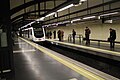
Cuatro Caminos is a station on Line 1, Line 2 and Line 6 of the Madrid Metro, located underneath the Cuatro Caminos roundabout on the border of Chamberí and Tetuán districts in Madrid. It is located in fare Zone A. The station was inaugurated on 17 October 1919, and was opened to the public on 31 October 1919.

<span class="mw-page-title-main">Ciudad Universitaria (Madrid Metro)</span> Madrid Metro station

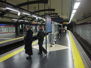
Ciudad Universitaria is a station on Line 6 of the Madrid Metro, located beneath Complutense avenue in the Ciudad Universitaria ward in the Moncloa-Aravaca district in fare Zone A. It is named after the Ciudad Universitaria, which is home to the Complutense University of Madrid, the Technical University of Madrid, and the National University of Distance Education. The station's platforms feature tilework representing the bear and the strawberry tree, which is a symbol of Madrid. The station is located next to the Ciudad Universitaria underground train storage depot, where most of Line 6's 5000 series trains are stored.

<span class="mw-page-title-main">Guzmán el Bueno (Madrid Metro)</span> Madrid Metro station

Guzmán el Bueno is a station on Line 6 and Line 7 of the Madrid Metro located underneath the Avenida de la Reina Victoria between the neighborhoods of Vallehermoso in Chamberí district and Ciudad Universitaria in Moncloa-Aravaca district in Madrid. It is in fare Zone A. The station was named after the Calle de Guzmán el Bueno, which is named for the medieval Spanish nobleman Alonso Pérez de Guzmán (1256–1309), known as Guzmán el Bueno.

<span class="mw-page-title-main">Diego de León (Madrid Metro)</span> Madrid Metro station

Diego de León is a station on Line 4, Line 5, and Line 6 of the Madrid Metro, located at the intersections of Francisco Silvela, Diego de León, and Conde de Peñalver streets in the Salamanca district of Madrid. It is in Zone A.

<span class="mw-page-title-main">O'Donnell (Madrid Metro)</span> Madrid Metro station

O'Donnell is a station on Line 6 of the Madrid Metro, located near the Royal Mint of Spain and in fare Zone A. It serves the neighborhoods of Goya and Fuente del Berro in the Salamanca district and the neighborhood of Ibiza in the Retiro district of Madrid. The station was inaugurated on 10 October 1979 along with all of the other stations between Pacífico and Cuatro Caminos. The station is named after Calle de O'Donnell, which in turn is named after the 19th-century Spanish politician Leopoldo O'Donnell.

<span class="mw-page-title-main">Bilbao (Madrid Metro)</span> Madrid Metro station

Bilbao is a station on Line 1 and Line 4 of the Madrid Metro. It is located in Zone A and is near to the Glorieta de Bilbao.

<span class="mw-page-title-main">Seville–Santa Justa railway station</span> Railway station in Spain

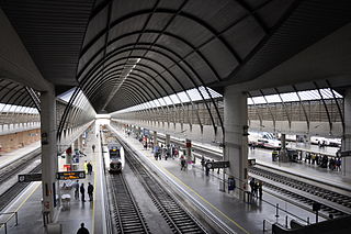
Seville–Santa Justa railway station is the major railway station of the Spanish city of Seville, Andalusia. It was opened in 1991 with the inauguration of the Madrid–Seville high-speed rail line, and serves around 9.25 million passengers a year.

References

  1. "Adiós a Vodafone Sol: la estación del metro de Madrid recupera su nombre original". eleconomista.es (in Spanish). 1 June 2016.

40°25′05″N3°41′57″W / 40.4180°N 3.6993°W / 40.4180; -3.6993