Linwood, Michigan

Last updated
Linwood, Michigan
Linwood, Michigan.jpg
USA Michigan location map.svg
Red pog.svg
Linwood
Location within the state of Michigan
Usa edcp location map.svg
Red pog.svg
Linwood
Linwood (the United States)
Coordinates: 43°44′21″N83°57′44″W / 43.73917°N 83.96222°W / 43.73917; -83.96222
Country United States
State Michigan
County Bay
Townships Fraser and Kawkawlin
Settled1872
Elevation
[1]
584 ft (178 m)
Time zone UTC-5 (Eastern (EST))
  Summer (DST) UTC-4 (EDT)
ZIP code(s)
48634
Area code 989
FIPS code 26-47880 [2]
GNIS feature ID630524 [1]

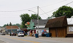
Linwood is a small unincorporated community in the northern portion of Bay County in the U.S. state of Michigan. The community is on the boundary between Fraser Township on the north and Kawkawlin Township on the south. It is situated with M-13 to the west and the Saginaw Bay of Lake Huron on the east, between Kaiser Tower Road and Elevator Road where Linwood Road becomes Center Street. [1] Bay City is about 12 miles to the south and Linwood is included in the Bay City Metropolitan Statistical Area.

Contents

The waters off Linwood in the Saginaw Bay are known for their excellent perch and walleye fishing. Walleye can typically be found in abundant numbers from May through mid-July, and make Linwood a destination for fishermen during the summer months. The local bars, restaurants, marina and campground make the village a popular destination for vacationers and fishermen during the summer.

The Nayanquing Point State Wildlife Area is three miles to the north while the Tobico Marsh is three miles to the south. Both are popular places for bird observation and the Wildlife Area is popular with seasonal waterfowl hunters.

Every August, the Pickle Festival is held in Linwood.

Radio station WSAG-FM (104.1) is licensed to Linwood by the Federal Communications Commission, though its studios are in Saginaw.

History

The settlement began as "Terry's Station", a depot on the Mackinaw division of the Michigan Central Railroad, named for James G. Terry, the head of a local lumber company. He was the first postmaster of a post office named "Terry Station", which opened on February 21, 1872. The office closed on February 16, 1874, but was reestablished on June 6, 1877. On June 28, 1882, the name was changed to Linwood, derived from a combination of the words "line" and "wood", since it was on the line between two different townships and it was also heavily wooded. The railroad station was renamed "Linwood Park". [3] [4]

ZIP code area and demographics

The Linwood post office has ZIP code 48634 and serves the northern portions of Kawkawlin Township and Beaver Township and the southern portions of Fraser Township and Garfield Township. [5] At the 2000 census, the population of the Zip Code Tabulation Area for 48634 was 4,684. [6]

Related Research Articles

<span class="mw-page-title-main">Bay County, Michigan</span> County in Michigan, United States

Bay County is located in the U.S. state of Michigan. As of the 2020 Census, the population was 103,856. The county seat is Bay City.

<span class="mw-page-title-main">Fraser Township, Michigan</span> Civil township in Michigan, United States

Fraser Township is a civil township of Bay County in the U.S. state of Michigan. The township's population was 3,192 as of the 2010 census. It is included in the Bay City Metropolitan Statistical Area.

<span class="mw-page-title-main">Berrien Township, Michigan</span> Civil township in Michigan, United States

Berrien Township is a civil township of Berrien County in the U.S. state of Michigan. As of the 2010 census, the township population was 5,084.

Clarendon Township is a civil township of Calhoun County in the U.S. state of Michigan. The population was 1,139 at the 2010 census. The township is part of the Battle Creek Metropolitan Statistical Area.

<span class="mw-page-title-main">Pickford Township, Michigan</span> Civil township in Michigan, United States

Pickford Township is a civil township of Chippewa County in the U.S. state of Michigan. As of the 2010 census, the township population was 1,595.

Sherman Township is a civil township of Iosco County in the U.S. state of Michigan. The population was 493 at the 2000 census and slightly decreased to 448 at the 2010 census.

Lapeer Township is a civil township of Lapeer County in the U.S. state of Michigan. The population was 5,056 at the 2010 Census. The name is an Americanization of the French La pierre, which means "flint" or "flint stone".

<span class="mw-page-title-main">Powell Township, Michigan</span> Civil township in Michigan, United States

Powell Township is a civil township of Marquette County in the U.S. state of Michigan. The population was 732 at the 2020 census.

Belvidere Township is a civil township of Montcalm County in the U.S. state of Michigan. As of the 2000 census, the township population was 2,438.

Montcalm Township is a civil township of Montcalm County in the U.S. state of Michigan. The population was 3,178 at the 2000 census.

Olive Township is a civil township of Ottawa County in the U.S. state of Michigan. The population was 5,007 at the 2020 census.

<span class="mw-page-title-main">Brant Township, Michigan</span> Civil township in Michigan, United States

Brant Township is a civil township of Saginaw County in the U.S. state of Michigan. As of the 2010 Census, the township population was 2,012.

<span class="mw-page-title-main">Bridgeport, Michigan</span> Census-designated place & unincorporated community in Michigan, United States

Bridgeport is an unincorporated community in Bridgeport Charter Township, Saginaw County in the U.S. state of Michigan. It is also a census-designated place (CDP) for statistical purposes. The population was 6,571 at the 2020 census. Bridgeport is also the name of a post office with ZIP code 48722. The area served by the ZIP code includes the southeast portion of the CDP and includes southeastern portions of Bridgeport Charter Township outside of the CDP as well as portions of southwest Frankenmuth Township and a small area of northeastern Birch Run Township. The remainder of the CDP area is served by the Saginaw ZIP code 48601.

<span class="mw-page-title-main">Carrollton Township, Michigan</span> Civil township in Michigan, United States

Carrollton Township is a civil township of Saginaw County in the U.S. state of Michigan. The population was 6,103 at the 2010 census. Established in 1866, Carrollton contains a full-time police department, fire department, parks and recreation services, as well as its own public school system, Carrollton Public Schools. Along with being located on the Saginaw River, Carrollton offers close access to shopping malls, medical facilities, Saginaw Valley State University, and I-75.

<span class="mw-page-title-main">Freeland, Michigan</span> Census-designated place & unincorporated community in Michigan, United States

Freeland is a census-designated place in Tittabawassee Township, Saginaw County in the U.S. state of Michigan. It is part of the Saginaw-Midland-Bay Metropolitan Area. As of the 2000 census, the CDP population was 5,147. The CDP covers an area in the central portion of Tittabawassee Township. The Freeland post office, ZIP code 48623, serves nearly the entire township, as well as portions of Midland and Williams townships to the north, Frankenlust and Kochville townships to the east, Thomas and Richland townships to the south, and Ingersoll Township to the west.

Minden Township is a civil township of Sanilac County in the U.S. state of Michigan. The population was 633 at the 2000 census.

<span class="mw-page-title-main">Akron Township, Michigan</span> Township in Michigan, United States

Akron Township is a civil township of Tuscola County in the U.S. state of Michigan. The population was 1,379 at the 2020 Census.

Wisner Township is a civil township of Tuscola County in the U.S. state of Michigan. The population was 690 at the 2010 Census.

Elba Township is a civil township of Lapeer County in the U.S. state of Michigan. The population was 5,250 at the 2010 Census.

Home Township is a civil township of Montcalm County in the U.S. state of Michigan. As of the 2000 census, the township population was 2,708.

References

  1. 1 2 3 U.S. Geological Survey Geographic Names Information System: Linwood, Michigan & GNIS in Google Maps
  2. "U.S. Census website". United States Census Bureau . Retrieved 2008-01-31.
  3. U.S. Geological Survey Geographic Names Information System: Linwood Post Office
  4. Romig, Walter (1986) [1973]. Michigan Place Names. Detroit, Michigan: Wayne State University Press. ISBN   0-8143-1838-X.
  5. ZCTA Reference Map for 48634 Archived 2020-02-10 at archive.today , U.S. Census Bureau, 2000 census
  6. 48634 5-Digit ZCTA Archived 2020-02-12 at archive.today , DP-1. Profile of General Demographic Characteristics, United States Census, 2000