
The Atlantic Ocean is the second-largest of the world's five oceans, with an area of about 85,133,000 km2 (32,870,000 sq mi). It covers approximately 17% of Earth's surface and about 24% of its water surface area. During the Age of Discovery, It was known for separating the "Old World" from the "New World".

The North Sea lies between Great Britain, Denmark, Norway, Germany, the Netherlands, Belgium and France. An epeiric sea on the European continental shelf, it connects to the Atlantic Ocean through the English Channel in the south and the Norwegian Sea in the north. It is more than 970 kilometres (600 mi) long and 580 kilometres (360 mi) wide, covering 570,000 square kilometres (220,000 sq mi).

Spain is a country located in southwestern Europe occupying most of the Iberian Peninsula. It also includes a small exclave inside France called Llívia, as well as the Balearic Islands in the Mediterranean, the Canary Islands in the Atlantic Ocean 108 km (67 mi) off northwest Africa, and five places of sovereignty on and off the coast of North Africa: Ceuta, Melilla, Islas Chafarinas, Peñón de Alhucemas, and Peñón de Vélez de la Gomera.

The East Coast of the United States, also known as the Eastern Seaboard, the Atlantic Coast, and the Atlantic Seaboard, is the region encompassing the coastline where the Eastern United States meets the Atlantic Ocean. The Thirteen Colonies, which formed the United States in 1776 were located on this coast, and it has played an important role in the development of the United States.

The Intracoastal Waterway (ICW) is a 3,000-mile (4,800 km) inland waterway along the Atlantic and Gulf of Mexico coasts of the United States, running from Massachusetts southward along the Atlantic Seaboard and around the southern tip of Florida, then following the Gulf Coast to Brownsville, Texas. Some sections of the waterway consist of natural inlets, saltwater rivers, bays, and sounds, while others are artificial canals. It provides a navigable route along its length without many of the hazards of travel on the open sea.

An ocean current is a continuous, directed movement of seawater generated by a number of forces acting upon the water, including wind, the Coriolis effect, breaking waves, cabbeling, and temperature and salinity differences. Depth contours, shoreline configurations, and interactions with other currents influence a current's direction and strength. Ocean currents are primarily horizontal water movements.

A nor'easter, is a large-scale extratropical cyclone in the western North Atlantic Ocean. The name derives from the direction of the winds that blow from the northeast. The term is commonly used in the winter in New England and Atlantic Canada.

Humpback dolphins are members of the genus Sousa. These dolphins are characterized by the conspicuous humps and elongated dorsal fins found on the backs of adults of the species. They are found close to shore along the coast of West Africa and right along the coast of the Indian Ocean from South Africa to Australia. Several institutions have made a proposal to divide the Indo-Pacific species into two distinct species: the Indo-Pacific humpback dolphin and the Australian humpback dolphin.

A coastal plain is flat, low-lying land adjacent to a sea coast. A fall line commonly marks the border between a coastal plain and a piedmont area. Some of the largest coastal plains are in Alaska and the southeastern United States. The Gulf Coastal Plain of North America extends northwards from the Gulf of Mexico along the Lower Mississippi River to the Ohio River, which is a distance of about 981 miles (1,579 km). The Atlantic Coastal Plain runs from the New York Bight to Florida.
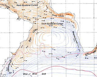
The Benguela Current is the broad, northward flowing ocean current that forms the eastern portion of the South Atlantic Ocean gyre. The current extends from roughly Cape Point in the south, to the position of the Angola-Benguela front in the north, at around 16°S. The current is driven by the prevailing south easterly trade winds. Inshore of the Benguela Current proper, the south easterly winds drive coastal upwelling, forming the Benguela Upwelling System. The cold, nutrient rich waters that upwell from around 200–300 m (656–984 ft) depth in turn fuel high rates of phytoplankton growth, and sustain the productive Benguela ecosystem.
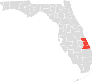
The Treasure Coast is a region in the southeast of the U.S. state of Florida. It borders the Atlantic Ocean and comprises Indian River, Martin, and St. Lucie counties. The region, whose name refers to the Spanish Treasure Fleet that was lost in a 1715 hurricane, evidently emerged from residents' desire to distinguish themselves from the Gold Coast to the south.

Berg wind is the South African name for a katabatic wind: a hot dry wind blowing down the Great Escarpment from the high central plateau to the coast.
The Cape Metropole has a wide variety of beaches divided into three regions by the Cape Peninsula:

The Portuguese Gold Coast was a Portuguese colony on the West African Gold Coast along the Gulf of Guinea. Established in 1482, the colony was officially incorporated into Dutch territory in 1642 following Portugal’s defeat in the Dutch-Portuguese War. From their seat of power at the fortress of São Jorge da Mina, the Portuguese commanded a vast internal slave trade, creating a slave network that would expand after the end of Portuguese colonialism in the region. The primary export of the colony was gold, which was obtained through barter with the local population. Portuguese presence along the Gold Coast increased seamanship and trade in the Gulf, introduced American crops into the African agricultural landscape, and made Portuguese an enduring language of trade in the area.

In North Carolina, the Crystal Coast is an 85-mile stretch of coastline that extends from the Cape Lookout National Seashore, which includes 56 miles of protected beaches, southwestward to the New River. The Crystal Coast is a popular area with tourists and second-home owners in the summer.

The Atlantic Plain is one of eight distinct physiographic divisions of the contiguous United States. Using the USGS physiographic classification system, the Atlantic Plain division comprises two provinces and six sections. The Coastal Plain province is differentiated from the Continental Shelf province simply based on the portion of the land mass above and below sea level.

The Tropical Atlantic realm is one of twelve marine realms that cover the world's coastal seas and continental shelves.
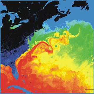
The Gulf Stream, together with its northern extension towards Europe, the North Atlantic Drift, is a warm and swift Atlantic ocean current that originates in the Gulf of Mexico and flows through the Straits of Florida and up the eastern coastline of the United States, then veers east near 36°N latitude and moves toward Northwest Europe as the North Atlantic Current. The process of western intensification causes the Gulf Stream to be a northward-accelerating current off the east coast of North America. Around 40°0′N30°0′W, it splits in two, with the northern stream, the North Atlantic Drift, crossing to Northern Europe and the southern stream, the Canary Current, recirculating off West Africa.
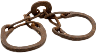
Panyarring was the practice of seizing and holding persons until the repayment of debt or resolution of a dispute which became a common activity along the Atlantic coast of Africa in the 18th and 19th centuries. The practice developed from pawnship, a common practice in West Africa where members of a family borrowing money would be pledged as collateral to the family providing credit until the repayment of the debt. Panyarring though is different from this practice as it involves the forced seizure of persons when a debt was not repaid.
