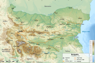
Bulgaria is a country situated in Southeast Europe that occupies the eastern quarter of the Balkan peninsula, being the largest country within its geographic boundaries. It borders Romania to the north, Serbia and North Macedonia to the west, Greece and Turkey to the south, and the Black Sea to the east. The northern border with Romania follows the river Danube until the city of Silistra. The land area of Bulgaria is 110,994 square kilometres (42,855 sq mi), slightly larger than that of Cuba, Iceland or the U.S. state of Tennessee. Considering its relatively compact territorial size and shape, Bulgaria has a great variety of topographical features. Even within small parts of the country, the land may be divided into plains, plateaus, hills, mountains, basins, gorges, and deep river valleys. The geographic center of Bulgaria is located in Uzana.
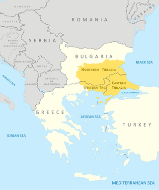
Thrace is a geographical and historical region in Southeast Europe. Bounded by the Balkan Mountains to the north, the Aegean Sea to the south, and the Black Sea to the east, it comprises present-day southeastern Bulgaria, northeastern Greece, and the European part of Turkey, roughly the Roman Province of Thrace. Lands also inhabited by ancient Thracians extended in the north to modern-day Northern Bulgaria and Romania and to the west into Macedonia.

The Thracians were an Indo-European speaking people who inhabited large parts of Southeast Europe in ancient history. Thracians resided mainly in Southeast Europe in modern-day Bulgaria, Romania, North Macedonia and northern Greece, but also in north-western Anatolia in Turkey.
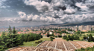
Stara Zagora is a city in Bulgaria, and the administrative capital of Stara Zagora Province. It is located in the Upper Thracian Plain, near the cities of Kazanlak, Plovdiv, and Sliven. Its population is 121,582 making it the sixth largest city of Bulgaria, located North East of Plovdiv.

Aligoté is a white grape used to make dry white wines, especially in the Burgundy region of France where it was first recorded in the 18th century. Since it is tolerant to cold, this variety is also cultivated in Eastern European countries. In 2004, it was the 22nd most planted vine variety in the world at 45,000 hectares.

The Timok, sometimes also known as Great Timok, is a river in eastern Serbia, a right tributary of the Danube. For the last 15 km of its run it forms a border between eastern Serbia and western Bulgaria.

Sredna Gora is a mountain range in central Bulgaria, situated south of and parallel to the Balkan Mountains and extending from the river Iskar to the west and the elbow of river Tundzha north of the city of Yambol to the east. Sredna Gora is 285 km long, reaching 50 km at its greatest width. Its highest peak is Golyam Bogdan at 1,604 m (5,262 ft). It is part of the Srednogorie mountain chain system, which extends longitudinally across the most country from west to east, between the Balkan Mountains and the Sub-Balkan valleys to the north and the Kraishte, Rila and the Upper Thracian Plain to the south.
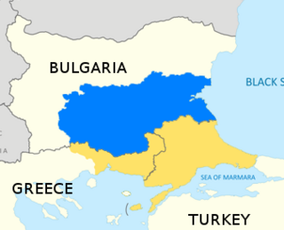
Northern Thrace or North Thrace, also called Bulgarian Thrace, constitutes the northern and largest part of the historical region of Thrace. It is located in Southern Bulgaria and includes the territory south of the Balkan Mountains and east of the Mesta River, bordering Western Thrace and East Thrace in the south, and the Black Sea in the east. It encompasses Sredna Gora, the Upper Thracian Plain, and 90% of the Rhodopes.
Grape growing and wine production have a long history in Bulgaria, dating back to the times of the Thracians. There is evidence of Bulgarian winemaking since 4000 B.C. Wine is, together with beer and grape rakia, among the most popular alcoholic beverages in the country.

The term Thraco-Roman describes the Romanized culture of Thracians under the rule of the Roman Empire.

The Upper Thracian Plain constitutes the northern part of the historical region of Thrace. It is located in southern Bulgaria, between Sredna Gora mountains to the north and west, a secondary mountain chain parallel to the main Balkan Mountains; the Rhodopes, Sakar and Strandzha to the south; and the Black Sea to the east. A fertile agricultural region, the Upper Thracian Plain proper has an area of 16,032 square kilometres (6,190 sq mi) and an average elevation of 168 metres (551 ft). The plain is part of Northern Thrace. The climate is transitional continental. The highest temperature recorded in Bulgaria occurred here: it was 45.2 °C (113.4 °F) at Sadovo in 1916. The precipitation is 550 millimetres (22 in) a year. Important rivers are the Maritsa and its tributaries, Arda, Tundzha, Stryama, Topolnitsa, and Vacha. Important cities include Plovdiv, Burgas, Stara Zagora, Pazardzhik, Asenovgrad, Haskovo, Yambol and Sliven.

Galabovo is a town in south-central Bulgaria, part of Stara Zagora Province. It is the administrative centre of the homonymous Galabovo Municipality. As of December 2022, the town had a population of 6,845.
Shivachevo is a small town in the Sliven Province located in the Tvarditsa Valley on the southern slopes of the Balkan Mountains in central eastern Bulgaria.
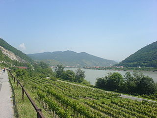
EuroVelo 6 (EV6), named the "Rivers Route", is a EuroVelo long-distance cycling route that runs along 3,653 km (2,270 mi) some of Europe's major rivers, including much of the Loire, some of the Saône, a short section of the upper Rhine and almost the entire length of Europe’s second longest river, the Danube — from the Atlantic coast of France to the city of Constanța on the Black Sea.
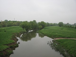
The Sazliyka or Rakitnitsa is a river in southeastern Bulgaria, a left tributary of the Maritsa. It originates in the Sarnena Sredna Gora mountain range. In its upper course until Radnevo, it is also known as the Rakitnitsa or Syuyutliyka. The river is 145 kilometres in length and is the fifth longest in the Maritsa drainage, following the Tundzha (390 km), the Arda (290 km), the Ergene (281 km) and the Topolnitsa (155 km).

Southern Bulgaria is the southern half of the territory of Bulgaria, located to the south of the main ridge of the Balkan Mountains which conventionally separates the country into a northern and a southern part. Besides the Balkan Mountains, Southern Bulgaria borders Serbia to the west, North Macedonia to the southwest, Greece to the south, Turkey to the southeast and the Bulgarian Black Sea Coast to the east.
Kran is a town in central Bulgaria. It is located just south of the Balkan Mountains and is administratively part of Kazanlak Municipality, Stara Zagora Province. Kran was an important castle of the Second Bulgarian Empire in the 13th–14th century. Among the local sights are a conserved ancient Thracian tomb, a much older Thracian sanctuary and the ruins of the medieval fortress.
The Chirpan Heights are a hilly ridge in the southernmost reaches of the Sredna Gora mountain range as it descends to the Upper Thracian Plain in central Bulgaria. Administratively, they lie in Stara Zagora Province.
The Blatnitsa is a river in southern Bulgaria, a left tributary of the river Sazliyka, itself a left tributary of the Maritsa. It has a length of 54 km.


