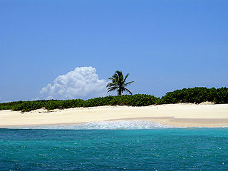
This article describes the geography of Anguilla.

Lively Island is the largest of the Lively Island Group of the Falkland Islands, The island group lies east of East Falkland. Lively Island is the largest rat-free island in the Falklands, hence its importance to birdlife. The island also has a sheep farm.

Don Edwards San Francisco Bay National Wildlife Refuge (DESFBNWR) is a United States National Wildlife Refuge located in the southern part of San Francisco Bay, California. The Refuge headquarters and visitor center is located in the Baylands district of Fremont, next to Coyote Hills Regional Park, in Alameda County. The visitor center is on Marshlands Rd, off Thornton Ave.

Scrub Island is an 8 km2 (3.1 sq mi) island lying off the eastern tip of the main island of Anguilla, a British Overseas Territory in the Caribbean. It is easily reached by boat. Privately owned, the remains of an abandoned air field still exist. There are several abandoned houses on the island, mainly due to damage from hurricanes. There is no electricity or plumbing.

The Passage Islands are a group of four islands in the Falkland Islands of the South Atlantic Ocean. They lie off Dunnose Head, West Falkland, at the mouth of King George Bay.

The Swan Bay is a shallow, 30-square-kilometre (12 sq mi) marine embayment at the eastern end of the Bellarine Peninsula in Port Phillip, Victoria, Australia. The township of Queenscliff lies at its southern end, and St Leonards at its northern. It is partly separated from Port Phillip by Swan Island, Duck Island and Edwards Point. Most of the area is included in the Port Phillip Heads Marine National Park as well as being listed as a wetland of international importance under the Ramsar Convention as part of the Port Phillip Bay and Bellarine Peninsula Ramsar Site. The bay is part of the Swan Bay and Port Phillip Bay Islands Important Bird Area, identified as such by BirdLife International because of its importance for orange-bellied parrots, waders and seabirds.

The Prickly Pear Cays, sometimes spelled Prickley Pear Cays, are a small pair of uninhabited islands about six miles from Road Bay, Anguilla, in the Leeward Islands of the Caribbean. They are divided by a narrow boat channel between Prickly Pear East and Prickly Pear West. Prickly Pear Cays were classified as 'wildlands' by the "Eastern Caribbean Natural Area Management Programme" (ECNAMP). In addition, Prickly Pear Cays are one of six marine protected areas of Anguilla.
Seal Bay is a bay, about 1 km across, on the rugged and exposed north coast of East Falkland in the Falkland Islands of the South Atlantic Ocean. It lies some 40 km north-west of Stanley.

Grey Pond is a 191 ha shallow, brackish lagoon at the eastern end of the main island of Anguilla, a British Overseas Territory in the Caribbean. Its southern and eastern shores are relatively steep-sided limestone slopes, while its north-eastern corner is separated from Savannah Bay by a belt of sand dunes. The limestone shores are covered by low, scrub vegetation.

Long Pond, also known as Long Salt Pond, is a 23 ha brackish lagoon on the central south-eastern coast of the main island of Anguilla, a British Overseas Territory in the Caribbean. About 1.2 km long, it is separated from the sea at its eastern end by sand dunes. Its south shore is separated from the sea by a 300 m wide strip of scrub vegetation on limestone. The area to the north and west is residential.
Malportas Pond is a salt-water pond on the north coast of Grand Cayman, Cayman Islands, near North Side village. It has an area of 44 or 52 hectares, and like the nearby Rock and Point ponds, it is an important area for breeding waterfowl. Local farmer Willie Ebanks introduced West Indian whistling-ducks on the pond in 1990, and it also has populations of heron, egrets, moorhens, and coots. It forms part of the Central Mangrove Wetland Important Bird Area, identified as such by BirdLife International because it supports populations of waterbirds.

Road Salt Pond, also known as Road Bay Pond or simply Road Pond, is a wetland in Anguilla, a British Overseas Territory in the Caribbean Sea. It is one of the territory’s Important Bird Areas (IBAs).

West End Pond is a wetland in Anguilla, a British Overseas Territory in the Caribbean Sea. It is one of the territory’s Important Bird Areas (IBAs).

Rendezvous Bay Pond, also known as Rendezvous Bay Salt Pond, is a wetland in Anguilla, a British Overseas Territory in the Caribbean Sea. It is one of the territory’s Important Bird Areas (IBAs).

Meads Bay Pond is a wetland in Anguilla, a British Overseas Territory in the Caribbean Sea. It is one of the territory’s Important Bird Areas (IBAs).

The Merrywing Pond System is a golf course wetland system in Anguilla, a British Overseas Territory in the Caribbean Sea. It forms one of the territory’s Important Bird Areas (IBAs).

Forest Bay Pond is a small wetland in Anguilla, a British Overseas Territory in the Caribbean Sea. It forms one of the territory’s Important Bird Areas (IBAs).


