Prickly Pear Cays

Last updated
Prickly Pear Cays
Anguilla Prickly-Pear.jpg
Prickly Pear Cays
Anguilla location map.svg
Red pog.svg
Prickly Pear Cays
The location of Prickly Pear Cays within Anguilla
Relief Map of Caribbean.png
Red pog.svg
Prickly Pear Cays
Prickly Pear Cays (Caribbean)
Geography
Location Atlantic Ocean
Coordinates 18°16′00″N63°11′00″W / 18.26667°N 63.18333°W / 18.26667; -63.18333 Coordinates: 18°16′00″N63°11′00″W / 18.26667°N 63.18333°W / 18.26667; -63.18333
Archipelago Antilles
Total islandsTwo
Administration
United Kingdom
British Overseas Territory Anguilla
Demographics
Population0 (2010)
Pop. density0/km2 (0/sq mi)
Ethnic groupsNone
Additional information
Time zone
ISO code AI

The Prickly Pear Cays, sometimes spelt as Prickley Pear Cays, are a small pair of uninhabited islands about six miles from Road Bay, Anguilla, in the Leeward Islands of the Caribbean. They are divided by a narrow boat channel between Prickly Pear East and Prickly Pear West. [1] [2] Prickly Pear Cays were classified as 'wildlands' by the "Eastern Caribbean Natural Area Management Programme" (ECNAMP). In addition, Prickly Pear Cays are one of six marine protected areas of Anguilla. [3]

Contents

Geography

Along with Dog, Scrub, Little Scrub, Seal, and Sombrero islets, the Prickly Pear Cays are located on the drowned Anguilla Bank. The cays are characterized by Early Miocene reefal limestone positioned upon Eocene-Oligocene volcanic rocks. These form a section of the active volcanic arc of the Lesser Antilles. [4] The two cays are located close to each other at 18°16′N63°11′W / 18.267°N 63.183°W / 18.267; -63.183 . They are accessible from Road Bay, Anguilla (6 miles (9.7 km) to its north) and Saint Martin either by catamaran or sail boat. [5] West Cay is longer than East Cay. North Cay, a 2 metres (6 ft 7 in) rock outcrop, is situated north of East Cay. [6] There is also a rock outcrop between Prickly Pear Cays and another cay known as Bush Cay, which is separated by a 0.5 miles (0.80 km) waterway. [2] Another rocky protrusion, known as Flirt Rocks, is situated north of Prickly Pear Cays. [6] Dog Island Channel separates Dog Island from the Prickly Pear Cays. [6]

West Cay is narrow, about 0.75 miles (1.21 km) long and rugged. Its western bay is covered with brush which rises to a height of 25 feet (7.6 m). With rocky coral reefs, it has no easy boat landing facility. [2]

East Cay is about 1 mile (1.6 km) long and 0.25 miles (0.40 km) wide. It has sparse vegetation and a sandy shoreline. The east cay also has salt ponds. [7]

Prickly Pear Cays have been designated as a marine park with permanent moorings. There is total ban on coral extraction or shells from underwater and spear fishing is not allowed. [8] The sea is generally calm. [8] [9] Prickly Pear Reef is an underwater canyon with ledges and caves whose depth varies from 40 feet (12 m) to 70 feet (21 m) and includes an underwater, chimney-like formation.

Geology

The geological formation in both the cays is of laminated calcareous sandstone. The layered stratigraphic formation is inferred to be due to "successive deposits by the tides or overflows from a troubled sea." [10] Over a long period of exposure, these formations have developed a laminated condition with the lamination beds of 25 mm (0.98 in) to 100 mm (3.9 in) thickness. The strata are disturbed in several sections. They have been assessed as suitable for use in pavements in view of their compact formation. [10]

At West Cay, an old quarry near a good harbour was used for exporting sandstone slabs. [10]

Flora and fauna

Along with certain sections of mainland Anguilla, Prickly Pear Cays were classified as 'wildlands' by ECNAMP in 1980. [11] Many types of plants, birds and reptiles have been recorded in both the cays. [7] Uncontrolled grazing by livestock is permitted in all the vegetation areas. [11]

Plants

Both cays are covered by shrubland. [1] The vegetation is dictated by the thin soil mantle and the presence of limestone cavities. Prickly pear, pope's head cactus and sea grape are the dominant plants. Other common plants are mauby bark, milky thorn, lignum vitae, sage cop, loblolly, nicker tree (only on Prickly Pear East), cockspur and balsam bush. [7]

Animals

Nurse shark Nurse shark.jpg
Nurse shark

Nesting birds are a common sight along the rocky coast line. [12] [13] The two cays have been identified as an Important Bird Area by BirdLife International because of their breeding seabirds. These include red-billed tropicbirds, brown pelicans, brown boobies, laughing gulls and least terns. Brown noddies and bridled terns also occur. Resident landbirds include Caribbean elaenias and yellow warblers. [14]

Numerous reptile species, such as Anguilla Bank anole and Anguilla Bank ameiva (on East Cay), are seen. Sea turtles also frequent the shores of the cays. [7]

Marine fauna in the reef area include schooling goatfish, crabs, lobsters, barracuda, angelfish, groupers, squirrelfish, butterflyfish, tarpon, mangrove snapper and grunts. Nurse sharks are also seen resting at the sandy bottom under the ledges of the caverns. [7] [8]

Tourism

The islands are popular with tourists due to the abundant marine and bird life. There are two restaurants and a bar which are serviced by staff who come in each day from the mainland of Anguilla. Thatch roofed structures provide the ambiance for the vistas of the turquoise blue seas which attract visitors to the cays. [12] [15] The East Cay has a landing area which requires careful maneoeuvring. [2] Snorkelling and diving are possible in the East Cay amidst the coral reefs, [12] with several sunken ships in the area. [16]

Related Research Articles

Anguilla British Overseas Territory in the Leeward Islands

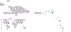
Anguilla is a British overseas territory in the Caribbean. It is one of the most northerly of the Leeward Islands in the Lesser Antilles, lying east of Puerto Rico and the Virgin Islands and directly north of Saint Martin. The territory consists of the main island of Anguilla, approximately 16 miles long by 3 miles (5 km) wide at its widest point, together with a number of much smaller islands and cays with no permanent population. The territory's capital is The Valley. The total land area of the territory is 35 square miles (91 km2), with a population of approximately 17,400.

Coral Sea Islands Australian external territory

The Coral Sea Islands Territory is an external territory of Australia which comprises a group of small and mostly uninhabited tropical islands and reefs in the Coral Sea, northeast of Queensland, Australia. The only inhabited island is Willis Island. The territory covers 780,000 km2 (301,160 sq mi), most of which is ocean, extending east and south from the outer edge of the Great Barrier Reef and includes Heralds Beacon Island, Osprey Reef, the Willis Group and fifteen other reef/island groups. Cato Island is the highest point in the Territory.

Caribbean Sea A sea of the Atlantic Ocean bounded by North, Central, and South America

The Caribbean Sea is an American mediterranean sea of the Atlantic Ocean in the tropics of the Western Hemisphere. It is bounded by Mexico and Central America to the west and south west, to the north by the Greater Antilles starting with Cuba, to the east by the Lesser Antilles, and to the south by the north coast of South America.

Geography of Anguilla

Anguilla is an island in the Leeward Islands, which lies between the Caribbean Sea in the west and the open Atlantic Ocean in the east. It is a long, flat, dry/wet, scrub-covered coral island, south and east of Puerto Rico and north of the Windward chain. It is separated from the British Virgin Islands by the Anegada Passage. The island has no significant elevations with its terrain consisting entirely of beaches, dunes, and low limestone bluffs.

Index of Anguilla-related articles Wikipedia list article

The following is an alphabetical list of topics related to the British Overseas Territory of Anguilla.

Cay small island formed on the surface of a coral reef

A cay, also spelled caye or key, is a small, low-elevation, sandy island on the surface of a coral reef. Cays occur in tropical environments throughout the Pacific, Atlantic and Indian Oceans.

Sombrero, Anguilla island

Sombrero, also known as Hat Island, is part of the British Overseas Territory of Anguilla and is the northernmost island of the Lesser Antilles. It lies 54 km (34 mi) north-west of Anguilla across the Dog and Prickly Pear Passage. The distance to Dog Island, the next nearest island of Anguilla, is 38 kilometres.

South Caicos seventh largest island in the Turks and Caicos islands archipelago

South Caicos is the seventh-largest island in the Turks and Caicos archipelago, with a land area of 21.2 square kilometres. South Caicos is known for excellent fishing, both deep-sea and bone fishing, and scuba diving. South Caicos was formerly a salt exporter, the island still hosts a network of salt pans as a reminder of the industry. Today, the island's main income is derived from small-scale commercial fishing.

Chesterfield Islands islands in New Caledonia

Chesterfield Islands are a French archipelago of New Caledonia located in the Coral Sea, 550 km northwest of Grande Terre, the main island of New Caledonia. The archipelago is 120 km long and 70 km broad, made up of 11 uninhabited islets and many reefs. The land area of the islands is less than 10 km².

Rosario Islands

The Islas del Rosario, also referred to as Corales Islas del Rosario, is an archipelago located off the coast of Colombia, approximately 100 kilometres from Cartagena. It is one of the 46 Natural National Parks of Colombia. The national park was founded in 1988, to protect one of the most important coral reefs of the Colombian Caribbean coast. People can visit the national park area of the islands, and tours are available. Isla Rosario has an aquarium and open-sea oceanarium (oceanario) that people can visit. Activities include swimming, snorkeling and fishing, among others.

Seal Island, Anguilla

Seal Island is a small island off the northwest coast of Anguilla. It is located some two kilometres to the east of the Prickly Pear Cays at 18° 16' N, 63° 9' W, and lies at the centre of the Seal island Reef System Marine Park.

Tryon Island Protected area in Queensland, Australia

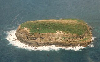
Tryon Island is a coral cay located in the southern Great Barrier Reef, 86 km northeast of Gladstone, Queensland, Australia, and 465 km north of the state capital Brisbane. The island is a protected area and forms part of Capricornia Cays National Park. It is part of the Capricornia Cays Important Bird Area. The cay covers an area of 0.21 square kilometres and is surrounded by a coral reef that is partially exposed at low-tide.

San Andrés (island) One of the two principal islands of San Andrés and Providencia

Coringa-Herald National Nature Reserve protected area

Coringa-Herald National Nature Reserve is a former nature reserve in Australia’s Coral Sea Islands Territory that was incorporated into the new Coral Sea Commonwealth Marine Reserve in December 2012. The former nature reserve together with the Lihou Reef National Nature Reserve is part of the Coral Sea Reserves Ramsar Site. Its extent is also within the Coringa-Herald Reefs Important Bird Area.

Old Providence McBean Lagoon National Natural Park National park in Colombia

The Old Providence McBean Lagoon National Natural Park is a national park located on the northeast side of Providencia Island in the Archipelago of San Andrés, Providencia and Santa Catalina, Colombia.

Dog Island, Anguilla island in Anguilla

Dog Island is an uninhabitated small island of 207 ha located approximately 13 km (8.1 mi) to the north-west of Anguilla. It is low and rocky, with three small cays off the west and north coasts. The coastline is characterised by low cliffs alternating with sandy beaches. Large ponds lie inside two of the beaches. Dog Island lies west of the Prickley Pear Cays.

Flirt Rocks mountain in Anguilla

Flirt Rocks are two small, uninhabited, rocky islets off of Anguilla, in the Leeward Islands of the Caribbean. They are located 0.75 miles (1.21 km) north of the Prickly Pear Cays. Seal Reef is situated east of the Flirt Rocks.

Bird Island Nature Reserve Protected area in New South Wales, Australia

The Bird Island Nature Reserve is a protected nature reserve located near Lake Munmorah on the Central Coast region of New South Wales, Australia. The island is situated 1.4 kilometres (0.87 mi) off the east coast of New South Wales, within the Tasman Sea. The reserve may be seen from the lighthouse at Norah Head.

Wildlife of Haiti

The wildlife of Haiti is important to the country because of its biodiversity. According to the World Conservation Monitoring Centre, Haiti is considered to be "one of the most biologically significant countries of the West Indies". With an estimated 5,600 plant species on the island of Hispaniola, some of which only occur in Haiti, 36% are considered as endemic to the island. A mountainous area country, it is situated in the western three-eighths of Hispaniola and shares a border with the Dominican Republic. There are nine life zones, from low desert to high cloud forests, as well as four mountain ranges, and hundreds of rivers and streams and the coral reefs in the seas that surround the islands. Issues of environmental damage, expanding population, deforesting and erosion are of concern; less than 2% of the original forest remains on account of deforestation. This degradation is traced from the 17th century to 19th century starting with the French colonization of the Haiti and population explosion during the 20th century and for the purpose of forestry and sugar-related industries, degraded the forests. and the environment.

References

  1. 1 2 United States Hydrographic Office (1927). West Indies Pilot. 1. U. S. Govt. printing office. Retrieved 10 February 2011.
  2. 1 2 3 4 Blunt, Edmund March; Blunt, George William (1863). The American coast pilot: containing directions for the principal harbors, capes, and headlands, on the coast of North and part of South America...with the prevailing winds, setting of the currents, &c., and the latitudes and longitudes of the principal harbors and capes; together with tide tables and variation. Edmund and George W. Blunt. p. 548. Retrieved 10 February 2011.
  3. Petit, Jérôme; Prudent, Guillaume. Climate change and biodiversity in the European Union overseas entities. IUCN. pp. 70–. ISBN   978-2-8317-1315-1 . Retrieved 12 February 2011.
  4. Ardus, D. A.; Champ, Michael A. (1990). Ocean Resources: Assessment and utilisation. Springer. pp. 28–. ISBN   978-0-7923-0952-9 . Retrieved 12 February 2011.
  5. Berkmoes, Ryan Ver (1 October 2008). Caribbean Islands. Lonely Planet. pp. 431–. ISBN   978-1-74059-575-9 . Retrieved 10 February 2011.
  6. 1 2 3 Sailing Directions (enroute): Caribbean Sea. ProStar Publications. January 2004. pp. 120–. ISBN   978-1-57785-567-5 . Retrieved 12 February 2011.
  7. 1 2 3 4 5 Food and Agriculture Organization of the United Nations (1998). Forestry policies in the Caribbean: Reports of 28 selected countries and territories. Food & Agriculture Org. pp. 2–. ISBN   978-92-5-104233-5 . Retrieved 10 February 2011.
  8. 1 2 3 Cameron, Sarah (1 January 2005). Antigua & Leeward Islands. Footprint Travel Guides. pp. 228–. ISBN   978-1-904777-09-0 . Retrieved 10 February 2011.
  9. Huber, Joyce; Huber, Jon (15 October 2006). Best Dives of the Caribbean. Hunter Publishing, Inc. pp. 13–. ISBN   978-1-58843-585-9 . Retrieved 10 February 2011.
  10. 1 2 3 Sawkins, James Gay; Wall, Georges Parkes; Barrett, Lucas; Lennox, Arthur; Barrington Brown, Charles (1869). Reports on the geology of Jamaica; or, Part II. of the West Indian survey. London, UK: Longmans, Green, and Co. p.  259 . Retrieved 10 February 2011.
  11. 1 2 World Conservation Monitoring Centre (1992). Nearctic and neotropical. IUCN. pp. 315–. ISBN   978-2-8317-0093-9 . Retrieved 12 February 2011.
  12. 1 2 3 "Prickly Pear Cays". Pricklypearanguilla.com. Archived from the original on 13 October 2009. Retrieved 10 February 2010.
  13. JPM Publications (1 April 2001). Caribbean. Hunter Publishing, Inc. pp. 98–. ISBN   978-2-88452-218-2 . Retrieved 12 February 2011.
  14. "Prickly Pear (East and West)". BirdLife data zone: Important Bird Areas. BirdLife International. 2012. Retrieved 2012-11-23.
  15. "Anguilla Prickly Pear:Lambada". Aquamania adventures. Archived from the original on 2010-09-11.
  16. Caswell, Chris (15 July 2001). Chartering a boat: your guide to a perfect holiday . Sheridan House, Inc. pp.  152–. ISBN   978-1-57409-111-3 . Retrieved 12 February 2011.