
Sheung Wan is an area in Hong Kong, located in the north-west of Hong Kong Island, between Central and Sai Ying Pun. Administratively, it is part of the Central and Western District. The name can be variously interpreted as Upper District, or Gateway District.

G. B. Pastine–Rome Ciampino Airport is the secondary international airport serving Rome, the capital of Italy, after Leonardo da Vinci–Rome Fiumicino Airport. It is a joint civilian, commercial and military airport situated 6.5 NM south southeast of central Rome, just outside the Greater Ring Road the circular motorway around the city.

Josh Silver is an American musician who is the former keyboardist, producer and backing vocalist of gothic metal band Type O Negative. He joined the band at frontman Peter Steele's request. He played for Type O Negative until they disbanded due to Steele's death in 2010.

The R25 is a provincial route in South Africa that connects Johannesburg with Groblersdal via Kempton Park, Bapsfontein and Bronkhorstspruit.

The Pistoia Mountains Astronomical Observatory, also known as the San Marcello Observatory and the Pian dei Termini Observatory, is an astronomical observatory in San Marcello Piteglio, Tuscany, central Italy.
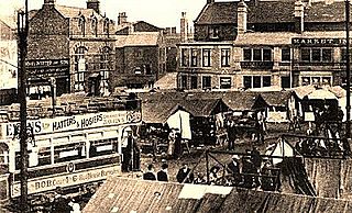
The Barnsley and District Electric Traction Co was an electric tramway network serving the town of Barnsley, South Yorkshire.
Route 213 is a collector road in the Canadian province of Nova Scotia. It is located in the Halifax Regional Municipality, connecting Bedford at Trunk 2 with Upper Tantallon at Trunk 3 with interchanges with Highway 102 and Highway 103 located near the termini.

Roma Termini is the main railway station of Rome, Italy. It is named after the district of the same name, which in turn took its name from ancient Baths of Diocletian, which lies across the street from the main entrance. It is Italy's busiest railway station and the fifth-busiest in Europe, with a traffic volume of approximately 150 million passengers per year, and with 850 trains in transit per day.

The MacArthur Highway, officially the Manila North Road, is a 684.855-kilometer (425.549 mi), two-to-six lane, national primary highway and tertiary highway in Luzon, Philippines, connecting Caloocan in Metro Manila to Aparri in Cagayan at the north. It is the second longest road in the Philippines, after Pan-Philippine Highway. It is primarily known as MacArthur Highway in segments from Caloocan to Urdaneta, Pangasinan, although it is also applied up to Ilocos Sur, and likewise called as Manila North Road for the entire length.

The Autostrada A20 is an autostrada 183 kilometres (114 mi) long on the island of Sicily that links the city of Messina to Termini Imerese. The motorway from Messina follows the Tyrrhenian coast until it meets the A19 Palermo-Catania at Buonfornello, a frazione of Termini Imerese. The Autostrada A20, at its eastern-end, is also connected to the A18 Messina-Catania.
Termini Airfield is an abandoned World War II military airfield on Sicily, located approximately 6 km East of Termini Imerese harbour.

The London Borough of Camden is a London borough in Inner London, England. Camden Town Hall, on Euston Road, lies 1.4 mi (2.3 km) north of Charing Cross. The borough was established on 1 April 1965 and includes the former Central London borough of Holborn, and St Pancras and Hampstead.

Municipio I is an administrative subdivision of the municipality of Rome, encompassing the centre of the city.

European route E 932 is a European B class road in Italy, connecting the hamlet of Buonfornello and Catania.

Metropolitan City of Rome Capital is an area of local government at the level of metropolitan city in the Lazio region of Italy. It comprises the territory of the city of Rome and 120 other comuni in the hinterland of the city. With more than 4.3 million inhabitants, it is the largest metropolitan city in Italy.

Route 434, also known as Conche Road, is a 23.6-kilometre-long (14.7 mi) east–west highway on the Great Northern Peninsula of Newfoundland in the Canadian province of Newfoundland and Labrador. It serves as the only road access to the town of Conche, connecting it with the town of Roddickton and Route 433.


