
The United States Numbered Highway System is an integrated network of roads and highways numbered within a nationwide grid in the contiguous United States. As the designation and numbering of these highways were coordinated among the states, they are sometimes called Federal Highways, but the roadways were built and have always been maintained by state or local governments since their initial designation in 1926.

U.S. Route 1 or U.S. Highway 1 (US 1) is a major north–south United States Numbered Highway that serves the East Coast of the United States. It runs 2,370 miles (3,810 km) from Key West, Florida, north to Fort Kent, Maine, at the Canadian border, making it the longest north–south road in the United States. US 1 is generally paralleled by Interstate 95 (I-95), though US 1 is significantly farther west and inland between Jacksonville, Florida, and Petersburg, Virginia, while I-95 is closer to the coastline. In contrast, US 1 in Maine is much closer to the coast than I-95, which runs farther inland than US 1. The route connects most of the major cities of the East Coast from the Southeastern United States to New England, including Miami, Jacksonville, Augusta, Raleigh, Richmond, Washington, D.C., Baltimore, Philadelphia, Newark, New York City, New Haven, Providence, Boston, and Portland.

U.S. Route 75 is a north–south U.S. Highway that runs 1,239 miles (1,994 km) in the central United States. The highway's northern terminus is located at the Canadian border near Noyes, Minnesota, at a now-closed border crossing. From this point, the highway once continued farther north as Manitoba Highway 75. Its southern terminus is located at Interstate 345 (I-345) and Texas State Highway Spur 366 in Dallas, Texas, where US 75 is known as North Central Expressway.

U.S. Route 2 or U.S. Highway 2 (US 2) is an east–west United States Numbered Highway spanning 2,571 miles (4,138 km) across the northern continental United States. US 2 consists of two segments connected by various roadways in southern Canada. Unlike some routes, which are disconnected into segments because of encroaching Interstate Highways, the two portions of US 2 were designed to be separate in the original 1926 highway plan.
A decommissioned highway is a highway that has been removed from service by being shut down, or has had its authorization as a national, provincial or state highway removed, the latter also referred to as downloading. Decommissioning can include the complete or partial demolition or abandonment of an old highway structure because the old roadway has lost its utility, but such is not always the norm. Where the old highway has continuing value, it likely remains as a local road offering access to properties denied access to the new road or for use by slow vehicles such as farm equipment and horse-drawn vehicles denied use of the newer highway.
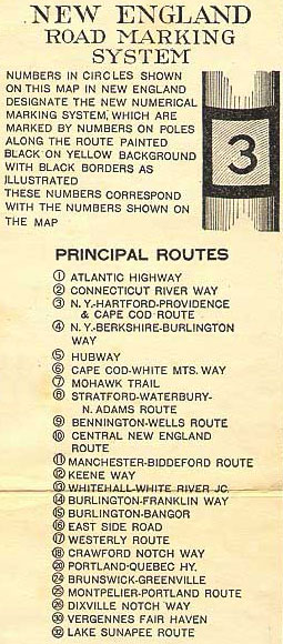
The New England road marking system was a regional system of marked numbered routes in the six-state region of New England in the United States. The routes were marked by a yellow rectangular sign with black numbers and border. Many signs were painted on telephone poles. The routes were approved by the highway departments of the six New England states in April 1922.

New Hampshire Route 18 is a 20.116-mile-long (32.374 km) state highway in northwestern New Hampshire. It is a local road serving Franconia, Bethlehem, and Littleton, New Hampshire, which I-93 bypasses. Its northern extension, Vermont Route 18, continues northward from the Connecticut River to St. Johnsbury, Vermont. NH 18 closely parallels I-93 for its entire length and has several interchanges with the Interstate highway.
The Arrowhead Trail or Arrowhead Highway was the first all-weather road in the Western United States that connected Los Angeles, California with Salt Lake City, Utah by way of Las Vegas, Nevada. Built primarily during the auto trails period of the 1910s, prior to the establishment of the United States Numbered Highway System, the road was replaced in 1926 by U.S. Route 91 (US 91) and subsequently Interstate 15 (I-15). Small portions of the route in California, Nevada and Utah are sometimes still referred to by the name, or as Arrow Highway.
U.S. Route 2 (US 2) is a part of the United States Numbered Highway System that is split into two segments. Its eastern segment runs from Rouses Point, New York, to Houlton, Maine. In Vermont, US 2 extends 150.518 miles (242.235 km) from the New York state line in Alburgh to the New Hampshire state line in Guildhall. West of Vermont, US 2 continues into New York for another 0.87 miles (1.40 km) to an intersection with US 11 in Rouses Point. US 2 passes through the cities of Burlington and Montpelier as it traverses the state. The highway parallels Interstate 89 (I-89) between these two cities. The Burlington to Montpelier route was first laid out as a toll road in the early 19th century. It was later incorporated into the transcontinental auto trail known as the Theodore Roosevelt International Highway in 1919 before being designated as part of US 2 in 1926.

Vermont Route 18 (VT 18) is a 7.887-mile-long (12.693 km) state highway in Caledonia County, Vermont, United States. It runs from the New Hampshire state line, continuing there as New Hampshire Route 18 northward to U.S. Route 2 (US 2) in the town of St. Johnsbury. The route parallels and connects to Interstate 93 (I-93) and is a former routing of the Theodore Roosevelt International Highway.

The Yellowstone Trail was the first transcontinental automobile highway through the upper tier of states in the United States, established on May 23, 1912. It was an Auto Trail that ran from the Atlantic Ocean in Plymouth, Massachusetts, through Montana to Yellowstone National Park in Wyoming, to the Pacific Ocean in Seattle, Washington. The road slogan was "A Good Road from Plymouth Rock to Puget Sound".

The Victory Highway was an auto trail across the United States between New York City and San Francisco, roughly equivalent to the present U.S. Route 40. It was created by the Victory Highway Association, which was organized in 1921 to locate and mark a transcontinental highway to be dedicated to American forces who died in World War I. A series of Victory Eagle sculptures were planned to mark the route, although only a few were actually built and placed.

The state highway system in the U.S. state of California dates back to 1896, when the state took over maintenance of the Lake Tahoe Wagon Road. Before then, roads and streets were managed exclusively by local governments. Construction of a statewide highway system began in 1912, after the state's voters approved an $18 million bond issue for over 3,000 miles (4,800 km) of highways. The last large addition was made by the California State Assembly in 1959, after which only minor changes have been made.

U.S. Route 6 (US-6) is an east–west United States Numbered Highway through the central part of the U.S. state of Utah. Although it is only about 40 miles (64 km) longer than US-50, it serves more populated areas and, in fact, follows what had been US-50's routing until it was moved to follow Interstate 70 (I-70) in 1976. In 2009, the Utah State Legislature named part of the route the "Mike Dmitrich Highway", named after the Utah state senator, which generated controversy, as the state of Utah had previously joined with all the other states through which US-6 passes in naming all of US-6 the Grand Army of the Republic Highway.
The Theodore Roosevelt International Highway was a transcontinental North American highway, from the era of the auto trails, through the United States and Canada that ran from Portland, Maine, to Portland, Oregon. Its length was about 4,060 miles (6,530 km).
U.S. Highway 75 (US 75) is a United States Highway in northwestern Iowa. It begins at the Missouri River on a bridge with Interstate 129 (I-129) and US 20. Immediately upon landing in Iowa from Nebraska, I-129 ends at an interchange with I-29. US 20 and US 75 continue around Sioux City on a four-lane expressway until US 20 exits to the east. US 75 heads to the north-northeast, parallel to the Floyd River, until Le Mars. There, Iowa Highway 60 (Iowa 60) continues northeastward on the expressway while US 75 heads due north. Near Hull, it is briefly overlapped by US 18. It leaves the state and enters Minnesota north of Rock Rapids.

The Wisconsin State Trunk Highway System is the state highway system of the U.S. state of Wisconsin, including Wisconsin's segments of the Interstate Highway System and the United States Numbered Highway System, in addition to its other state trunk highways. These separate types of highways are respectively designated with an I-, US, or STH- prefix. The system also includes minor roads designated as Scenic Byways, four routes intended to promote tourism to scenic and historic areas of the state; and as Rustic Roads, lightly traveled and often unpaved local roads which the state has deemed worthy of preservation and protection. The state highway system, altogether totaling 11,753 miles (18,915 km) across all of Wisconsin's 72 counties, is maintained by the Wisconsin Department of Transportation (WisDOT).
In late 1925, the Iowa State Highway Commission, now known as the Iowa Department of Transportation, announced plans to renumber several state highways. The changes to the highway system were a result of the creation of the United States Numbered Highway System. The new U.S. Highways replaced several of the state's primary roads and other routes were renumbered in order to eliminate driver confusion between the two systems. As the new highways were being signed, Iowa's state highways were given a new circular route marker. Previously, the primary road number was stenciled in black onto a telegraph pole over a band of yellow paint.

U.S. Highway 59 (US 59) is a United States Highway that transverses the western third of Iowa. It begins at the Missouri state line southwest of Northboro and travels north in a zigzag pattern through Shenandoah, Avoca, Denison, and Cherokee. It ends at the Minnesota state line east of Bigelow, Minnesota. The highway was designated in 1934, though a concerted effort of community officials along today's route sought to bring a U.S. Highway to their cities for several years prior to US 59's creation.
