This article needs additional citations for verification .(November 2020) |
List of archaeological sites in County Armagh, Northern Ireland:
This article needs additional citations for verification .(November 2020) |
List of archaeological sites in County Armagh, Northern Ireland:

Rathcroghan is a complex of archaeological sites near Tulsk in County Roscommon, Ireland. It is identified as the site of Cruachan, the traditional capital of the Connachta, the prehistoric and early historic rulers of the western territory. The Rathcroghan Complex is a unique archaeological landscape with many references found in early Irish medieval manuscripts.
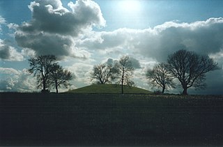
Navan Fort is an ancient ceremonial monument near Armagh, Northern Ireland. According to tradition it was one of the great royal sites of pre-Christian Gaelic Ireland and the capital of the Ulaidh. It is a large circular hilltop enclosure—marked by a bank and ditch—inside which is a circular mound and the remains of a ring barrow. Archeological investigations show that there were once buildings on the site, including a huge roundhouse-like structure that has been likened to a temple. In a ritual act, this timber structure was filled with stones, deliberately burnt down and then covered with earth to create the mound which stands today. It is believed that Navan was a pagan ceremonial site and was regarded as a sacred space. It features prominently in Irish mythology, especially in the tales of the Ulster Cycle. According to the Oxford Dictionary of Celtic Mythology, "the [Eamhain Mhacha] of myth and legend is a far grander and mysterious place than archeological excavation supports".

Beaghmore is a complex of early Bronze Age megalithic features, stone circles and cairns, 8.5 miles north west of Cookstown, County Tyrone in Northern Ireland, on the south-east edge of the Sperrin Mountains.

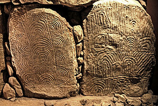
Knowth is a Neolithic passage grave and an ancient monument of the World Heritage Site of Brú na Bóinne located 8.4 km west of Drogheda in Ireland's valley of the River Boyne. It is the largest passage grave of the Brú na Bóinne complex. It consists of a large mound and 17 smaller satellite tombs. The mound is about 12 metres (40 ft) high and 67 metres (220 ft) in diameter, covering roughly a hectare. It contains two passages placed along an east-west line and is encircled by 127 kerbstones, of which three are missing, and four badly damaged.

The Grianan of Aileach, sometimes anglicised as Greenan Ely or Greenan Fort, is a hillfort atop the 244 metres (801 ft) high Greenan Mountain at Inishowen in County Donegal, Ireland. The main structure is a stone ringfort, thought to have been built by the Northern Uí Néill, in the sixth or seventh century CE; although there is evidence that the site had been in use before the fort was built. It has been identified as the seat of the Kingdom of Ailech and one of the royal sites of Gaelic Ireland. The wall is about 4.5 metres (15 ft) thick and 5 metres (16 ft) high. Inside it has three terraces, which are linked by steps, and two long passages within it. Originally, there would have been buildings inside the ringfort. Just outside it are the remains of a well and a tumulus.

The Hill of Uisneach or Ushnagh is a hill and ancient ceremonial site in the barony of Rathconrath in County Westmeath, Ireland. It is a protected national monument. It consists of numerous monuments and earthworks—prehistoric and medieval—including a probable megalithic tomb, burial mounds, enclosures, standing stones, holy wells and a medieval road. Uisneach is near the geographical centre of Ireland, and in Irish mythology it is deemed to be the symbolic and sacred centre of the island. It was said to be the burial place of the mythical Tuatha Dé Danann, and a place of assembly associated with the druids and the festival of Bealtaine.

Knocknakilla is the site of a megalithic complex situated between Macroom and Millstreet, in County Cork, Ireland. It is set in blanket peatland on the north-west upper slopes of Musherabeg mountain and is thought to be 3500 years old.
Mochrum is a coastal civil and Church of Scotland parish situated to the east of Luce Bay on the Machars peninsula and 8 miles (13 km) southwest of Wigtown and in the historical county of Wigtownshire in Galloway, Scotland. It covers 22,000 acres (8,900 ha) and is approximately 10 miles (16 km) in length and 5 miles (8.0 km) in breadth. The parish contains the eponymous village of Mochrum, as well as Port William and the clachan of Elrig.

In archaeology, earthworks are artificial changes in land level, typically made from piles of artificially placed or sculpted rocks and soil. Earthworks can themselves be archaeological features, or they can show features beneath the surface.
Gavrinis is a small island in the Gulf of Morbihan in Brittany, France. It contains the Gavrinis tomb, a megalithic monument notable for its abundance of megalithic art in the European Neolithic. Administratively, it is part of the commune of Larmor-Baden.

Reyfad is a townland in County Fermanagh, Northern Ireland. It lies in the land division of Old Barr, in the civil parish of Boho. The townland has previously been called Rayfadd - 1659, Raffada (Magheryboy) - 1672 and Ráith Fada "long fort" - 1833.

Aghanaglack or Aghnaglack, is a townland in County Fermanagh, Northern Ireland. It is situated in the civil parish of Boho, as well as Fermanagh and Omagh district.

The unchambered long barrowearthen long barrow, non-megalithic long barrow or non-megalithic mound, is a type of long barrow found across the British Isles, in a belt of land in Brittany, and in northern Europe as far east as the River Vistula. The term "unchambered" means that there is no stone chamber within the stone enclosure. In Great Britain they are often known as non-megalithic long barrows or unchambered long cairns.

Radergan is a townland in County Tyrone, Northern Ireland. It is situated in the barony of Omagh East and the civil parish of Clogherny and covers an area of 919 acres.
The main reference for all sites listed is: NI Environment Agency, Scheduled Historic Monuments (to 15 October 2012), unless otherwise indicated.