Related Research Articles

Armagh is the county town of County Armagh and a city in Northern Ireland, as well as a civil parish. It is the ecclesiastical capital of Ireland – the seat of the Archbishops of Armagh, the Primates of All Ireland for both the Roman Catholic Church and the Church of Ireland. In ancient times, nearby Navan Fort was a pagan ceremonial site and one of the great royal capitals of Gaelic Ireland. Today, Armagh is home to two cathedrals and the Armagh Observatory, and is known for its Georgian architecture.

Keady is a village and civil parish in County Armagh, Northern Ireland. It is south of Armagh and near the border with the Republic of Ireland. It is situated mainly in the historic barony of Armagh with six townlands in the barony of Tiranny. It had a population of 3,051 people in the 2011 Census.

Loughgall is a small village, townland and civil parish in County Armagh, Northern Ireland. It is in the historic baronies of Armagh and Oneilland West. It had a population of 282 people in the 2011 Census.

Blackwatertown is a small village in County Armagh, Northern Ireland. It sits on the River Blackwater, in the townland of Lisbofin, at the border with County Tyrone. The villages of Benburb and Moy are nearby. Blackwatertown had a population of 376 in the 2011 Census. The River Blackwater enters Lough Neagh west of Derrywarragh Island and is navigable from Maghery to Blackwatertown.

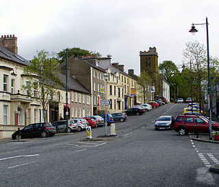
Newtownhamilton is a small town and civil parish in County Armagh, Northern Ireland. It lies predominantly within Tullyvallan townland. The civil parish is within the historic barony of Fews Upper. In the 2011 Census it had 2,836 inhabitants.
Richhill is a large village and townland in County Armagh, Northern Ireland. It lies between Armagh and Portadown. It had a population of 2,821 people in the 2011 Census.

Acton is a hamlet and townland of 22 acres in County Armagh, Northern Ireland, about a half mile north of Poyntzpass. It is situated in the civil parish of Ballymore and the historic barony of Orior Lower and within the Armagh City, Banbridge and Craigavon Borough Council area. It had a population of 72 people in the 2011 Census.

Caledon is a small village and townland in County Tyrone, Northern Ireland. It is in the Clogher Valley on the banks of the River Blackwater, 7 miles from Armagh. It lies in the southeast of Tyrone and near the borders of County Armagh and County Monaghan. It is situated in the historic barony of Dungannon Lower and the civil parish of Aghaloo. In the 2001 Census it had a population of 387 people. It is a designated conservation area. It was historically known as Kinnaird (Irish: Cionn Aird, meaning "head/top of the height or hill".
Derrynoose is a village and civil parish in south County Armagh, Northern Ireland, 4.5 km south-west of Keady.

Killyman is a small village and a civil parish in Northern Ireland, situated on the eastern boundary of County Tyrone and extending into County Armagh. The majority of townlands are in the historic barony of Dungannon Middle in County Tyrone, the rest being in the barony of Oneilland West in County Armagh.

Aughanduff is a small village and townland in the civil parish of Forkhill, in the former barony of Orior Upper, and County of Armagh, Northern Ireland. The townland is roughly co-existent with Upper and Lower Aughanduff Mountains, both of which form part of the Ring of Gullion geological formation, which has been described as the most spectacular example of a ring-dyke intrusion in the British Isles, and was the first ring dyke in the world to be geologically mapped. Aughanduff has been populated since prehistoric times and has been recorded as a distinct district since at least the early 1600s. The area's history is both well documented and reflects its location both in rural Ireland and on the borderlands of the Pale, the Plantation of Ulster, and latterly Northern Ireland; indeed, part of the district's northern boundary was proposed for forming part of the northern border of the Irish Free State by the Irish Boundary Commission in its final report of 1925. The Boundary Commission's report was never implemented and today, the area remains within Northern Ireland, some five miles from the border with the Republic of Ireland. Part of the area has been designated by the Northern Ireland Environment Agency as an Area of Special Scientific Interest, and the district lies within the Ring of Gullion Area of Outstanding Natural Beauty.
Derrycrew is a townland of 444 acres in County Armagh, Northern Ireland. It is situated in the civil parish of Loughgall and the historic barony of Oneilland West.

Poyntzpass is a small village on the border between southern County Armagh and County Down in Northern Ireland. It is situated in the civil parish of Ballymore and the historic barony of Orior Lower within the Armagh City and District Council area. It had a population of 552 people in the 2011 Census. It was a part of the South Armagh constituency and is now part of the Newry and Armagh constituency, and was one of the places in South Armagh where the Ulster Covenant could be signed.

Annaghmore is a small village and townland near Loughgall in County Armagh, Northern Ireland. It is situated in the civil parish of Loughgall and the historic barony of Oneilland West. It is within the Armagh City and District Council area. It had a population of 265 people in the 2011 Census.
Ballygasey is a townland of 205 acres in County Armagh, Northern Ireland. It is situated in the civil parish of Loughgall and the historic barony of Oneilland West.
Federnagh is a townland of 234 acres in County Armagh, Northern Ireland. It is situated in the civil parish of Ballymore and the historic barony of Orior Lower.
Monclone is a townland of 245 acres in County Armagh, Northern Ireland. It is situated in the civil parish of Ballymore and the historic barony of Orior Lower.
References
- ↑ "Tannyoky". Place Names NI. Retrieved 14 May 2015.
- ↑ "Tannyoky". IreAtlas Townlands Database. Retrieved 14 May 2015.

| | This article related to the geography of County Armagh, Northern Ireland is a stub. You can help Wikipedia by expanding it. |