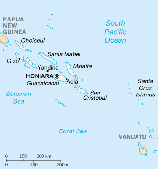
This is a list of populated places in the nation state of Solomon Islands , it excludes areas within the Solomon Islands archipelago that fall under a different jurisdiction, such as Bougainville.
This is a list of populated places in the nation state of Solomon Islands , it excludes areas within the Solomon Islands archipelago that fall under a different jurisdiction, such as Bougainville.

This is a list of villages of the Faroe Islands.
This is intended to be a complete list of historic properties and districts listed on the National Register of Historic Places located on islands other than Manhattan Island but still in New York County, New York. For all properties and districts in the borough of Manhattan, see National Register of Historic Places listings in New York County, New York. The locations of National Register properties and districts may be seen in an online map by clicking on "Map of all coordinates".
Fletcher Island is a Baffin Island offshore island located in the Arctic Archipelago in the territory of Nunavut. The island lies in Frobisher Bay, north of Newell Sound. The Hall Peninsula is to the east. Islands in the immediate vicinity include: Field Island to the east; Bruce Island to the northeast; Pike and Pugh Islands to the west.

During World War II, the United States Army Air Forces engaged in combat against the air, ground and naval forces of the Empire of Japan in the South West Pacific Theatre.

During World War II, the United States Army Air Forces engaged in combat against the Empire of Japan in the South Pacific Area. As defined by the War Department, this consisted of the Pacific Ocean areas which lay south of the Equator between longitude 159° East and 110° West. It included New Zealand, New Caledonia, New Hebrides, Fiji, and most of the Solomon Islands.
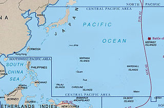
During World War II, the United States Army Air Forces fought the Empire of Japan in the Central Pacific Area. As defined by the War Department, this consisted of most of the Pacific Ocean and its islands, excluding the Philippines, Australia, the Netherlands East Indies, the Territory of New Guinea the Solomon Islands and areas to the south and east of the Solomons.

The South Pacific air ferry route was initially established in the 1920s to ferry United States Army Air Service aircraft to the Philippines. As the Japanese threat in the Far East increased in 1940, General Douglas MacArthur planned that in the event of war, the United States Army Air Corps would play a major role in defending the Philippines. The reinforcement by the Air Corps of forces in the Philippines, and later Allied forces in Australia, became the basis for developing the South Pacific air ferry route used during World War II.
